 |
|
Eastern Sierra Regional Airport |
| Eastern Sierra Regional Airport |
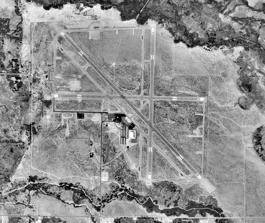 |
| USGS aerial photo as of 3 August 1999 |
| IATA: BIH – ICAO: KBIH – FAA LID: BIH |
| Summary |
| Airport type |
Public |
| Owner |
City of Los Angeles, Dept. of Public Works |
| Serves |
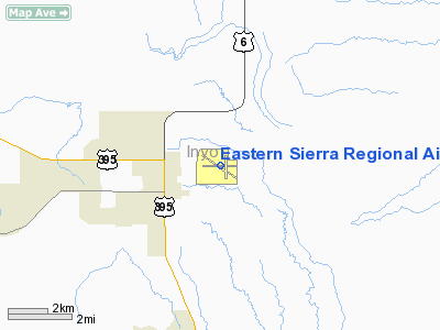
Bishop, California |
| Location |
Inyo County, east of Bishop |
| Elevation AMSL |
4,124 ft / 1,257 m |
| Coordinates |
37°22′23″N 118°21′49″W / 37.37306°N 118.36361°W / 37.37306; -118.36361 |
| Runways |
| Direction |
Length |
Surface |
| ft |
m |
| 7/25 |
5,566 |
1,697 |
Asphalt |
| 12/30 |
7,498 |
2,285 |
Asphalt |
| 16/34 |
5,600 |
1,707 |
Asphalt |
| Helipads |
| Number |
Length |
Surface |
| ft |
m |
| H1 |
40 |
12 |
Asphalt |
| H2 |
100 |
30 |
Asphalt |
| Statistics (2006) |
| Aircraft operations |
26,000 |
| Based aircraft |
64 |
| Source: Federal Aviation Administration |
Eastern Sierra Regional Airport (IATA: BIH, ICAO: KBIH, FAA LID: BIH) is a public-use airport located two nautical miles (4 km) east of the central business district of Bishop, in Inyo County, California, United States. It is owned by the City of Los Angeles, Department of Public Works. History
The airfield was opened in April 1940. During World War II the airfield was known as Bishop Army Airfield and was used by the United States Army Air Forces Air Technical Service Command. With the end of the war, the base was declared excess to requirements and returned to civil control.
Facilities and aircraft
Eastern Sierra Regional Airport covers an area of 830 acres (336 ha) at an elevation of 4,124 feet (1,257 m) above mean sea level. It has three asphalt paved runways: 7/25 is 5,566 by 100 feet (1,697 x 30 m); 12/30 is 7,498 by 100 feet (2,285 x 30 m); 16/34 is 5,600 by 100 feet (1,707 x 30 m). It also has two helipads: H1 is 40 by 40 feet (12 x 12 m) and H2 is 100 by 100 feet (30 x 30 m).
For the 12-month period ending October 23, 2006, the airport had 26,000 aircraft operations, an average of 71 per day: 88% general aviation and 12% military. At that time there were 64 aircraft based at this airport: 81% single-engine, 13% multi-engine, 2% jet and 5% glider.
The above content comes from Wikipedia and is published under free licenses – click here to read more.
Location
& QuickFacts
|
FAA
Information Effective: |
2006-06-08 |
|
Airport
Identifier: |
BIH |
|
Longitude/Latitude: |
118-21-49.0000W/37-22-23.2000N
-118.363611/37.373111 (Estimated) |
|
Elevation: |
4124 ft / 1257.00 m (Estimated) |
|
Land: |
830 acres |
|
From
nearest city: |
2 nautical miles E of Bishop, CA |
|
Location: |
Inyo County, CA |
|
Magnetic Variation: |
15E (1985) |
Owner
& Manager
|
Ownership: |
Publicly owned |
|
Owner: |
City Of Los Angeles, Dept Of Public
LEASED, CONSTRUCTED AND MAINTAINED BY INYO COUNTY. |
|
Address: |
300 Mandich Street
Bishop, CA 93514 |
|
Phone
number: |
(760)
873-03 |
|
Manager: |
Steve Ivey
DIR OF PUBLIC WORKS INYO COUNTY. |
|
Address: |
703 Airport Road
Bishop, CA 93514 |
|
Phone number: |
(760) 872-29
COUNTY COURTHOUSE INDEPENDENCE. |
Airport
Operations and Facilities
|
Airport
Use: |
Open to public |
|
Wind
indicator: |
Yes |
|
Segmented
Circle: |
Yes |
|
Control
Tower: |
No |
|
Attendance
Schedule: |
ALL/MON-FRI/0730-1800,ALL/SAT-SUN/0700-1700
ADMIN OFFICE AT ARPT (760) 872-2971. |
|
Lighting
Schedule: |
DUSK-DAWN
ACTVT MIRL RY 07/25; HIRL RYS 12/30 & 16/34; VASI RYS
12; 30; 16 & 34 - CTAF. |
|
Beacon
Color: |
Clear-Green (lighted land airport) |
|
Landing
fee charge: |
No |
|
Sectional
chart: |
San Francisco |
|
Region: |
AWP - Western-Pacific |
|
Traffic
Pattern Alt: |
1000 ft |
|
Boundary
ARTCC: |
ZOA - Oakland |
|
Tie-in
FSS: |
RAL - Riverside |
|
FSS
on Airport: |
No |
|
FSS
Phone: |
951-351-3020 |
|
FSS
Toll Free: |
1-800-WX-BRIEF |
|
NOTAMs
Facility: |
BIH (NOTAM-d service avaliable) |
|
Federal Agreements: |
NGPY3 |
Airport
Communications
|
CTAF: |
123.000 |
|
Unicom: |
123.000 |
Airport
Services
|
Fuel
available: |
100LLA |
|
Airframe
Repair: |
MAJOR |
|
Power
Plant Repair: |
MAJOR |
|
Bulk
Oxygen: |
LOW |
|
Runway Information
Runway 07/25
|
Dimension: |
5566
x 100 ft / 1696.5 x 30.5 m
PVD SHOULDER 10' TO LGTS PLUS 15' TO EDGE.
PVD
SHOULDER 10' TO LGTS PLUS 15' TO EDGE. |
|
Surface: |
ASPH, Good Condition |
|
Weight
Limit: |
Single wheel: 40000 lbs.
Dual wheel: 56000 lbs.
Dual
tandem wheel: 98000 lbs. |
|
Edge
Lights: |
Medium |
|
|
Runway 07 |
Runway 25 |
|
Longitude: |
118-22-26.8853W |
118-21-17.9450W |
|
Latitude: |
37-22-25.1380N |
37-22-24.6584N |
|
Elevation: |
4124.00 ft |
4100.00 ft |
|
Alignment: |
90 |
127 |
|
Traffic
Pattern: |
Left |
Left |
|
Markings: |
Non-precision instrument, Good Condition |
Non-precision instrument, Good Condition |
|
Runway
End Identifier: |
No |
No |
|
Centerline
Lights: |
No |
No |
|
Touchdown
Lights: |
No |
No |
|
Obstruction: |
35 ft trees, 800.0 ft from runway, 17:1 slope
to clear |
, 50:1 slope to clear
10' DEEP DITCH 100' FROM THR. |
|
Runway 12/30
|
Dimension: |
7498
x 100 ft / 2285.4 x 30.5 m
PVD SHOULDER 10' TO LGTS PLUS 15' TO EDGE.
PVD
SHOULDER 10' TO LGTS PLUS 15' TO EDGE. |
|
Surface: |
ASPH, Good Condition |
|
Surface
Treatment: |
Porous Friction Course |
|
Weight
Limit: |
Single wheel: 70000 lbs.
Dual wheel: 110000 lbs.
Dual
tandem wheel: 200000 lbs. |
|
Edge
Lights: |
High |
|
|
Runway 12 |
Runway 30 |
|
Longitude: |
118-22-24.0136W |
118-21-18.9130W |
|
Latitude: |
37-22-48.5082N |
37-21-55.6490N |
|
Elevation: |
4123.00 ft |
4100.00 ft |
|
Alignment: |
127 |
127 |
|
Traffic
Pattern: |
Left |
Left |
|
Markings: |
Non-precision instrument, Good Condition |
Non-precision instrument, Good Condition |
|
Crossing
Height: |
48.00 ft |
55.00 ft |
|
VASI: |
2-box on left side |
2-box on left side
VASI RY 30 UNUSBL BYD 1 NM. |
|
Visual
Glide Angle: |
3.00� |
3.50� |
|
Runway
End Identifier: |
No |
No |
|
Centerline
Lights: |
No |
No |
|
Touchdown
Lights: |
No |
No |
|
Obstruction: |
55 ft trees, 950.0 ft from runway, 200 ft left
of centerline, 13:1 slope to clear |
25 ft pline, 1200.0 ft from runway, 40:1 slope
to clear |
|
Runway 16/34
|
Dimension: |
5600
x 100 ft / 1706.9 x 30.5 m
PVD SHOULDER 10' TO LGTS PLUS 15' TO EDGE.
PVD
SHOULDER 10' TO LGTS PLUS 15' TO EDGE. |
|
Surface: |
ASPH, Good Condition |
|
Surface
Treatment: |
Porous Friction Course |
|
Weight
Limit: |
Single wheel: 100000 lbs.
Dual wheel: 140000 lbs.
Dual
tandem wheel: 240000 lbs. |
|
Edge
Lights: |
High |
|
|
Runway 16 |
Runway 34 |
|
Longitude: |
118-21-41.8999W |
118-21-42.4944W |
|
Latitude: |
37-22-50.6414N |
37-21-55.2880N |
|
Elevation: |
4112.00 ft |
4105.00 ft |
|
Alignment: |
127 |
0 |
|
Traffic
Pattern: |
Left |
Left |
|
Markings: |
Non-precision instrument, Good Condition |
Non-precision instrument, Good Condition |
|
Crossing
Height: |
39.00 ft |
39.00 ft |
|
VASI: |
2-box on left side
VASI RY 16 UNUSBL BYD 1 NM. |
2-box on left side
VASI RY 34 UNUSBL BYD 1 NM. |
|
Visual
Glide Angle: |
3.00� |
3.00� |
|
Runway
End Identifier: |
No |
No |
|
Centerline
Lights: |
No |
No |
|
Touchdown
Lights: |
No |
No |
|
Obstruction: |
, 50:1 slope to clear |
60 ft trees, 1400.0 ft from runway, 20:1 slope
to clear |
|
Helipad H1
|
Dimension: |
40
x 40 ft / 12.2 x 12.2 m
PVD SHOULDER 10' TO LGTS PLUS 15' TO EDGE.
PVD
SHOULDER 10' TO LGTS PLUS 15' TO EDGE. |
|
Surface: |
ASPH, Fair Condition |
|
|
Runway H1 |
Runway |
|
Traffic
Pattern: |
Left |
Left |
|
Helipad H2
|
Dimension: |
100
x 100 ft / 30.5 x 30.5 m
PVD SHOULDER 10' TO LGTS PLUS 15' TO EDGE.
PVD
SHOULDER 10' TO LGTS PLUS 15' TO EDGE. |
|
Surface: |
ASPH, Fair Condition |
|
|
Runway H2 |
Runway |
|
Traffic
Pattern: |
Left |
Left |
|
Radio Navigation
Aids
|
ID |
Type |
Name |
Ch |
Freq |
Var |
Dist |
|
BIH |
VOR/DME |
Bishop |
033X |
109.60 |
15E |
0.3 nm |
|
OAL |
VORTAC |
Coaldale |
124X |
117.70 |
17E |
47.2 nm |
Remarks
- HAND
GLIDER ACTIVITY INVOF ARPT.
- NO
STRAIGHT-IN APCHS; NO INTERSECTION DEPS; HELICOPTER TFC APCH ARPT FM
THE WEST BOUNDARY.
- DUE
TO HIGH APCH MINS PILOTS MAY NEED AN IFR ALTN EVEN THOUGH WX IS FCST
TO BE HIGHER THAN 2000-3.
Based Aircraft
|
Aircraft
based on field: |
84 |
|
Single
Engine Airplanes: |
75 |
|
Multi
Engine Airplanes: |
6 |
|
Gliders: |
3 |
Operational Statistics
|
Aircraft
Operations: |
72/Day |
|
General
Aviation Local: |
26.9% |
|
General
Aviation Itinerant: |
61.5% |
|
Military: |
11.5% |
Eastern Sierra Regional Airport
Address:
Inyo County, CA
Tel:
(760)
873-03,
(760) 872-29
Images
and information placed above are from
http://www.airport-data.com/airport/BIH/
We
thank them for the data!
| General
Info |
| Country |
United
States |
| State |
CALIFORNIA
|
| FAA ID |
BIH
|
| Time |
UTC-8(-7DT)
|
| Latitude |
37.373094
37� 22' 23.14" N |
| Longitude |
-118.363608
118� 21' 48.99" W |
| Elevation |
4124 feet
1257 meters |
| Type |
Civil
|
| Magnetic
Variation |
014� E
(01/06) |
| Beacon |
Yes
|
| Operating
Agency |
U.S.CIVIL
AIRPORT WHEREIN PERMIT COVERS USE BY TRANSIT MILITARY AIRCRAFT
|
| Operating
Hours |
SEE REMARKS
FOR OPERATING HOURS OR COMMUNICATIONS FOR POSSIBLE HOURS |
| Daylight
Savings Time |
First
Sunday in April at 0200 to last Sunday in October at 0200 local time
(Exception Arizona and that portion of Indiana in the Eastern Time
Zone) |
We don't guarantee the information is fresh and accurate. The data may
be wrong or outdated.
For more up-to-date information please refer to other sources.
|
|


