 |
|
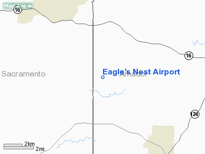
Location
& QuickFacts
|
FAA
Information Effective: |
2006-06-08 |
|
Airport
Identifier: |
CA20 |
|
Longitude/Latitude: |
121-00-53.7930W/38-25-49.6790N
-121.014943/38.430466 (Estimated) |
|
Elevation: |
220 ft / 67.06 m (Estimated) |
|
Land: |
600 acres |
|
From
nearest city: |
7 nautical miles SE of Ione, CA |
|
Location: |
Amador County, CA |
|
Magnetic Variation: |
16E (1985) |
Owner
& Manager
|
Ownership: |
Privately owned |
|
Owner: |
Eagle's Nest Partnership |
|
Address: |
Po Box 1539
Ione, CA 95640 |
|
Phone number: |
209-274-9160 |
|
Manager: |
W. D. Wardall & Partners |
|
Address: |
Po Box 1539
Ione, CA 95640 |
|
Phone number: |
209-274-9160 |
Airport
Operations and Facilities
|
Airport
Use: |
Private |
|
Wind
indicator: |
Yes |
|
Segmented
Circle: |
Yes |
|
Control
Tower: |
No |
|
Attendance
Schedule: |
ALL/ALL/ALL |
|
Sectional
chart: |
San Francisco |
|
Region: |
AWP - Western-Pacific |
|
Boundary
ARTCC: |
ZOA - Oakland |
|
Tie-in
FSS: |
RIU - Rancho Murieta |
|
FSS
Phone: |
916-354-0161 |
|
FSS
Toll Free: |
1-800-WX-BRIEF |
|
Runway Information
Runway 01/19
|
Dimension: |
4000
x 100 ft / 1219.2 x 30.5 m
1200 FT OVERRUN NORTH END OF RY . |
|
Surface: |
ASPH, |
|
|
Runway 01 |
Runway 19 |
|
Traffic
Pattern: |
Left |
Right |
|
Radio Navigation
Aids
|
ID |
Type |
Name |
Ch |
Freq |
Var |
Dist |
|
TCY |
NDB |
Tracy |
|
203.00 |
15E |
48.8 nm |
|
SUU |
TACAN |
Travis |
113X |
|
17E |
45.2 nm |
|
BAB |
TACAN |
Beale |
023X |
|
16E |
46.8 nm |
|
TZZ |
VOR |
Travis |
|
116.40 |
17E |
37.8 nm |
|
HNW |
VOR/DME |
Hangtown |
102X |
115.50 |
17E |
21.6 nm |
|
MCC |
VOR/DME |
Mc Clellan |
029X |
109.20 |
17E |
23.2 nm |
|
MYV |
VOR/DME |
Marysville |
045X |
110.80 |
16E |
47.9 nm |
|
MOD |
VOR/DME |
Modesto |
093X |
114.60 |
17E |
48.3 nm |
|
LIN |
VORTAC |
Linden |
095X |
114.80 |
17E |
21.4 nm |
|
SAC |
VORTAC |
Sacramento |
099X |
115.20 |
17E |
25.3 nm |
|
ECA |
VORTAC |
Manteca |
107X |
116.00 |
17E |
36.6 nm |
|
SAC |
VOT |
Sacramento Executive |
|
111.40 |
|
23.3 nm |
|
SMF |
VOT |
Sacramento Metropolitan |
|
111.40 |
|
31.3 nm |
Remarks
- PROVIDED
PRIVATE USE ONLY, AND UNDER VFR CONDITIONS.
Based Aircraft
|
Aircraft
based on field: |
19 |
|
Single
Engine Airplanes: |
12 |
|
Multi
Engine Airplanes: |
6 |
|
Jet Engine
Airplanes: |
1 |
Eagle's Nest Airport
Address:
Amador County, CA
Tel:
209-274-9160
Images
and information placed above are from
http://www.airport-data.com/airport/CA20/
We
thank them for the data!
| General
Info |
| Country |
United
States |
| State |
CALIFORNIA
|
| FAA ID |
CA20
|
| Latitude |
38-25-49.679N
|
| Longitude |
121-00-53.793W
|
| Elevation |
220 feet
|
| Near City |
IONE
|
We don't guarantee the information is fresh and accurate. The data may
be wrong or outdated.
For more up-to-date information please refer to other sources.
|
|


