 |
|
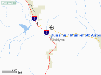
Dunsmuir Muni-mott Airport |
| Dunsmuir Municipal-Mott Airport |
| IATA: none – ICAO: none – FAA LID: 1O6 |
| Summary |
| Airport type |
Public |
| Owner |
City of Dunsmuir |
| Serves |
Dunsmuir, California |
| Elevation AMSL |
3,258 ft / 993 m |
| Coordinates |
41°15′47″N 122°16′20″W / 41.26306°N 122.27222°W / 41.26306; -122.27222 |
| Runways |
| Direction |
Length |
Surface |
| ft |
m |
| 14/32 |
2,700 |
823 |
Asphalt |
| Statistics (2007) |
| Aircraft operations |
500 |
| Based aircraft |
20 |
| Source: Federal Aviation Administration |
Dunsmuir Municipal-Mott Airport (FAA LID: 1O6) is a city-owned public-use airport located three nautical miles (6 km) north of the central business district of Dunsmuir, a city in Siskiyou County, California, United States.
Facilities and aircraft
Dunsmuir Municipal-Mott Airport covers an area of 126 acres (51 ha) at an elevation of 3,258 feet (993 m) above mean sea level. It has one runway designated 14/32 with a 2,700 by 60 ft (823 x 18 m) asphalt pavement.
For the 12-month period ending December 31, 2007, the airport had 500 aircraft operations, an average of 41 per month, all of which were general aviation. At that time there were 20 aircraft based at this airport, all single-engine.
The above content comes from Wikipedia and is published under free licenses – click here to read more.
Location
& QuickFacts
|
FAA
Information Effective: |
2006-06-08 |
|
Airport
Identifier: |
1O6 |
|
Longitude/Latitude: |
122-16-19.0300W/41-15-47.5520N
-122.271953/41.263209 (Estimated) |
|
Elevation: |
3258 ft / 993.04 m (Estimated) |
|
Land: |
126 acres |
|
From
nearest city: |
3 nautical miles N of Dunsmuir, CA |
|
Location: |
Siskiyou County, CA |
|
Magnetic Variation: |
17E (1985) |
Owner
& Manager
|
Ownership: |
Publicly owned |
|
Owner: |
City Of Dunsmuir |
|
Address: |
5915 Dunsmuir Ave
Dunsmuir, CA 96025 |
|
Phone
number: |
530-235-4822 |
|
Manager: |
Carl Morzenti
CITY MGR. |
|
Address: |
5915 Dunsmuir Ave
Dunsmuir, CA 96025
CITY HALL. |
|
Phone number: |
530-235-4822
CITY HALL, EXT 102 |
Airport
Operations and Facilities
|
Airport
Use: |
Open to public |
|
Wind
indicator: |
Yes |
|
Segmented
Circle: |
Yes |
|
Control
Tower: |
No |
|
Attendance
Schedule: |
UNATNDD |
|
Lighting
Schedule: |
DUSK-DAWN |
|
Beacon
Color: |
Clear-Green (lighted land airport)
BEACON OTS INDEFINITELY. |
|
Landing
fee charge: |
No |
|
Sectional
chart: |
Klamath Falls |
|
Region: |
AWP - Western-Pacific |
|
Traffic
Pattern Alt: |
1000 ft |
|
Boundary
ARTCC: |
ZOA - Oakland |
|
Tie-in
FSS: |
RIU - Rancho Murieta |
|
FSS
on Airport: |
No |
|
FSS
Phone: |
916-354-0161 |
|
FSS
Toll Free: |
1-800-WX-BRIEF |
|
NOTAMs
Facility: |
RIU (NOTAM-d service avaliable) |
|
Federal Agreements: |
NGY |
Airport
Communications
Airport
Services
|
Airframe
Repair: |
NONE |
|
Power
Plant Repair: |
NONE |
|
Bottled
Oxygen: |
NONE |
|
Bulk
Oxygen: |
NONE |
|
Runway Information
Runway 14/32
|
Dimension: |
2700
x 60 ft / 823.0 x 18.3 m
200 FT STOPWAYS BOTH ENDS OF RY. |
|
Surface: |
ASPH, Good Condition |
|
Weight
Limit: |
Single wheel: 12500 lbs. |
|
Edge
Lights: |
Medium
RY 14/32 MIRL OTS INDEFLY. |
|
|
Runway 14 |
Runway 32 |
|
Traffic
Pattern: |
Right |
Left |
|
Markings: |
Basic, Good Condition
RY 14/32 MARKINGS FADED. |
Basic, Good Condition |
|
Displaced
threshold: |
345.00 ft |
0.00
ft |
|
Runway
End Identifier: |
No |
No |
|
Centerline
Lights: |
No |
No |
|
Touchdown
Lights: |
No |
No |
|
Obstruction: |
135 ft trees, 1900.0 ft from runway, 220 ft
left of centerline, 12:1 slope to clear
RWY 14 APPROACH SLOPE 16:1 TO DISPLACED THRESHOLD |
, 50:1 slope to clear |
|
Radio Navigation
Aids
|
ID |
Type |
Name |
Ch |
Freq |
Var |
Dist |
|
MOG |
NDB |
Montague |
|
404.00 |
19E |
29.4 nm |
|
FJS |
VOR/DME |
Fort Jones |
033X |
109.60 |
19E |
26.6 nm |
|
RDD |
VOR/DME |
Redding |
021X |
108.40 |
18E |
45.6 nm |
Remarks
- ARPT
SURROUNDED BY HIGH MOUNTAINS.
- ARPT
CLSD TO NIGHT OPNS.
- RISING
TERRAIN, UNLIGHTED OBSTACLES NORTH AND EAST OF RY.
- RY
32 CLSD FOR TKOFFS.
- RY
14 CLSD FOR LNDGS.
Based Aircraft
|
Aircraft
based on field: |
20 |
|
Single
Engine Airplanes: |
20 |
Operational Statistics
|
Aircraft
Operations: |
10/Week |
|
General
Aviation Local: |
100.0% |
Dunsmuir Muni-mott Airport
Address:
Siskiyou County, CA
Tel:
530-235-4822
Images
and information placed above are from
http://www.airport-data.com/airport/1O6/
We
thank them for the data!
| General
Info |
| Country |
United
States |
| State |
CALIFORNIA
|
| FAA ID |
1O6
|
| Latitude |
41-15-47.552N
|
| Longitude |
122-16-19.030W
|
| Elevation |
3258 feet
|
| Near City |
DUNSMUIR
|
We don't guarantee the information is fresh and accurate. The data may
be wrong or outdated.
For more up-to-date information please refer to other sources.
|
|


