 |
|
| Chino Airport |
 |
| FAA airport diagram |
| IATA: CNO – ICAO: KCNO – FAA LID: CNO |
| Summary |
| Airport type |
Public |
| Owner |
County of San Bernardino |
| Location |
Chino, California |
| Elevation AMSL |
652 ft / 199 m |
| Coordinates |
33°58′29″N 117°38′12″W / 33.97472°N 117.63667°W / 33.97472; -117.63667 |
| Website |
co.san-bernardino.ca.us |
| Runways |
| Direction |
Length |
Surface |
| ft |
m |
| 3/21 |
6,023 |
1,836 |
Asphalt |
| 8L/26R |
4,858 |
1,481 |
Asphalt |
| 8R/26L |
7,000 |
2,134 |
Asphalt |
| Statistics (2006) |
| Aircraft operations |
168,393 |
| Based aircraft |
947 |
| Source: Federal Aviation Administration |
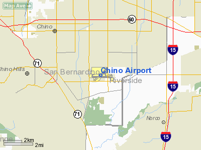
Chino Airport (IATA: CNO, ICAO: KCNO, FAA LID: CNO) is a county-owned public-use airport located three miles (5 km) southeast of the central business district of Chino, a city in San Bernardino County, California, United States. According to the FAA's National Plan of Integrated Airport Systems for 2007–2011, it is categorized as a reliever airport, due to its proximity to LA/Ontario International Airport and John Wayne Airport. History
Cal-Aero Academy was an independent flying school at Chino Airport when World War II started. The Army Air Forces contracted with the school to provide primary flight training for Army Air Cadets. During the war, Cal-Aero operated the training base with Stearmans and BT-13s. The name Cal-Aero is preserved at the airport and can be seen on several buildings.
After the war, hundreds of former combat aircraft were flown into Chino for disposal. The agricultural area was employed as a vast parking lot for ex-military aircraft. Soon, the entire area was filled with a wide variety of planes - everything from T-6s to B-24s. Most planes would meet an undignified end in portable smelters which were brought in to convert the warplanes into aluminum ingots.
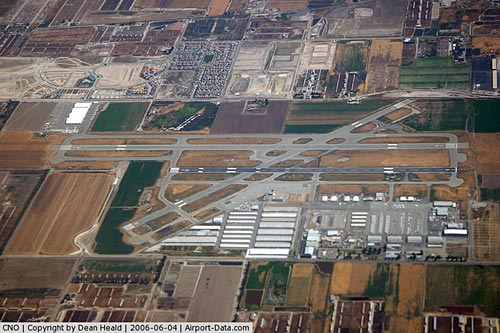
Chino Airport is also home to two aircraft museums, the Planes of Fame and the Yanks Air Museum, and is recognized as one of the centers of aircraft restoration and preservation with several different companies that provide those services co-located on the airport property.
Facilities and aircraft
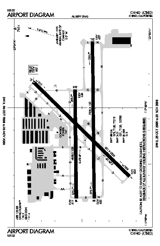
Chino Airport covers an area of 1,097 acres (444 ha) which contains three asphalt paved runways:
- Runway 3/21: 6,023 x 150 ft (1,836 x 46 m)
- Runway 8L/26R: 4,858 x 150 ft (1,481 x 46 m)
- Runway 8R/26L: 7,000 x 150 ft (2,134 x 46 m)
For the 12-month period ending March 27, 2006, the airport had 168,393 aircraft operations, an average of 461 per day: 99.9% general aviation and <1% military. There are 947 aircraft based at this airport: 77% single-engine, 18% multi-engine, 4% jet and 1% helicopter.
The above content comes from Wikipedia and is published under free licenses – click here to read more.
|
 |
(Click on the photo to enlarge) |
Location
& QuickFacts
|
FAA
Information Effective: |
2006-06-08 |
|
Airport
Identifier: |
CNO |
|
Longitude/Latitude: |
117-38-11.8000W/33-58-28.9000N
-117.636611/33.974694 (Estimated) |
|
Elevation: |
652 ft / 198.73 m (Surveyed) |
|
Land: |
1097 acres |
|
From
nearest city: |
3 nautical miles SE of Chino, CA |
|
Location: |
San Bernardino County, CA |
|
Magnetic Variation: |
14E (2000) |
Owner
& Manager
|
Ownership: |
Publicly owned |
|
Owner: |
County Of San Bernardino |
|
Address: |
825 E 3rd St
San Bernardino, CA 92415 |
|
Phone number: |
909-387-7800 |
|
Manager: |
John Frymyer |
|
Address: |
7000 Merrill Box 1
Chino, CA 91710-9091 |
|
Phone number: |
909-597-3910 |
Airport
Operations and Facilities
|
Airport
Use: |
Open to public |
|
Wind
indicator: |
Yes |
|
Segmented
Circle: |
Yes |
|
Control
Tower: |
Yes |
|
Attendance
Schedule: |
ALL/ALL/ALL |
|
Lighting
Schedule: |
RDO-CTL
ACTVT VASI RWY 21 WHEN ATCT CLSD - 118.5. |
|
Landing
fee charge: |
No |
|
Sectional
chart: |
Los Angeles |
|
Region: |
AWP - Western-Pacific |
|
Traffic
Pattern Alt: |
750 ft |
|
Boundary
ARTCC: |
ZLA - Los Angeles |
|
Tie-in
FSS: |
RAL - Riverside |
|
FSS
on Airport: |
No |
|
FSS
Phone: |
951-351-3020 |
|
FSS
Toll Free: |
1-800-WX-BRIEF |
|
NOTAMs
Facility: |
CNO (NOTAM-d service avaliable) |
|
Federal Agreements: |
NGPY |
Airport
Communications
|
CTAF: |
118.500 |
|
Unicom: |
122.950 |
Airport
Services
|
Fuel
available: |
100LLA
SELF-SERVICE FUEL AVBL 24 HRS. |
|
Airframe
Repair: |
MAJOR |
|
Power
Plant Repair: |
MAJOR |
|
Bottled
Oxygen: |
NONE |
|
Bulk
Oxygen: |
LOW |
|
Runway Information
Runway 03/21
|
Dimension: |
6023 x 150 ft / 1835.8 x 45.7 m |
|
Surface: |
ASPH, Good Condition |
|
Weight
Limit: |
Single wheel: 21000 lbs.
Dual wheel: 130000 lbs.
Dual dual tandem wheel: 50000 lbs. |
|
Edge
Lights: |
Medium
MIRL RY 08L/26R OTS INDEFLY. |
|
|
Runway 03 |
Runway 21 |
|
Longitude: |
117-38-36.5972W |
117-37-46.5470W |
|
Latitude: |
33-58-08.9725N |
33-58-51.5286N |
|
Elevation: |
604.00 ft |
652.00 ft |
|
Alignment: |
44 |
127 |
|
Traffic
Pattern: |
Right |
Left |
|
Markings: |
Non-precision instrument, Good Condition |
Non-precision instrument, Good Condition |
|
VASI: |
|
4-box on left side |
|
Visual
Glide Angle: |
0.00� |
3.00� |
|
Runway
End Identifier: |
No |
Yes
REIL RY 21 OTS INDEFLY. |
|
Centerline
Lights: |
No |
No |
|
Touchdown
Lights: |
No |
No |
|
Obstruction: |
40 ft trees, 1290.0 ft from runway, 250 ft
left of centerline, 27:1 slope to clear |
15 ft road, 750.0 ft from runway, 250 ft left
of centerline, 36:1 slope to clear |
|
Runway 08L/26R
|
Dimension: |
4858 x 150 ft / 1480.7 x 45.7 m |
|
Surface: |
ASPH, Good Condition |
|
Weight
Limit: |
Single wheel: 12000 lbs. |
|
Edge
Lights: |
High
MIRL RY 08L/26R OTS INDEFLY. |
|
|
Runway 08L |
Runway 26R |
|
Longitude: |
117-38-48.3179W |
117-37-50.6371W |
|
Latitude: |
33-58-32.5541N |
33-58-33.0451N |
|
Elevation: |
617.00 ft |
636.00 ft |
|
Alignment: |
89 |
127 |
|
ILS
Type: |
|
ILS
|
|
Traffic
Pattern: |
Right |
Left |
|
Markings: |
Basic, Good Condition |
Precision instrument, Good Condition |
|
Crossing
Height: |
0.00 ft |
51.00 ft |
|
VASI: |
|
4-light PAPI on left side |
|
Visual
Glide Angle: |
0.00� |
3.00� |
|
Runway
End Identifier: |
No |
No |
|
Centerline
Lights: |
No |
No |
|
Touchdown
Lights: |
No |
No |
|
Obstruction: |
65 ft trees, 1571.0 ft from runway, 140 ft
left of centerline, 21:1 slope to clear |
60 ft trees, 2150.0 ft from runway, 250 ft
left of centerline, 32:1 slope to clear |
|
Runway 08R/26L
|
Dimension: |
7000 x 150 ft / 2133.6 x 45.7 m |
|
Surface: |
ASPH, Good Condition |
|
Surface
Treatment: |
Saw-cut or plastic Grooved |
|
Weight
Limit: |
Single wheel: 75000 lbs.
Dual wheel: 150000 lbs.
Dual
tandem wheel: 215000 lbs. |
|
Edge
Lights: |
Medium
MIRL RY 08L/26R OTS INDEFLY. |
|
|
Runway 08R |
Runway 26L |
|
Longitude: |
117-38-48.2172W |
117-37-25.1082W |
|
Latitude: |
33-58-24.6455N |
33-58-25.3419N |
|
Elevation: |
620.00 ft |
636.00 ft |
|
Alignment: |
89 |
127 |
|
Traffic
Pattern: |
Right |
Left |
|
Markings: |
Non-precision instrument, Good Condition |
Non-precision instrument, Good Condition |
|
Crossing
Height: |
50.00 ft |
50.00 ft |
|
VASI: |
4-light PAPI on left side |
4-light PAPI on left side |
|
Visual
Glide Angle: |
3.00� |
3.00� |
|
Obstruction: |
, 50:1 slope to clear |
55 ft trees, 1320.0 ft from runway, 75 ft left
of centerline, 20:1 slope to clear |
|
Radio Navigation
Aids
|
ID |
Type |
Name |
Ch |
Freq |
Var |
Dist |
|
SB |
NDB |
Petis |
|
397.00 |
14E |
14.3 nm |
|
EMT |
NDB |
El Monte |
|
359.00 |
15E |
20.8 nm |
|
CPM |
NDB |
Compton |
|
378.00 |
15E |
30.9 nm |
|
SJY |
NDB |
San Jacinto |
|
227.00 |
14E |
33.6 nm |
|
PAI |
NDB |
Pacoima |
|
370.00 |
15E |
42.3 nm |
|
RIV |
TACAN |
March |
077X |
|
14E |
18.5 nm |
|
NFG |
TACAN |
Camp Pendleton |
055X |
|
13E |
43.9 nm |
|
RAL |
VOR |
Riverside |
|
112.40 |
15E |
9.4 nm |
|
HDF |
VOR |
Homeland |
|
113.40 |
14E |
25.5 nm |
|
ELB |
VOR/DME |
El Toro |
119X |
117.20 |
14E |
18.6 nm |
|
VCV |
VOR/DME |
Victorville |
031X |
109.40 |
14E |
39.2 nm |
|
SMO |
VOR/DME |
Santa Monica |
045X |
110.80 |
15E |
40.9 nm |
|
VNY |
VOR/DME |
Van Nuys |
078X |
113.10 |
15E |
45.1 nm |
|
PDZ |
VORTAC |
Paradise |
059X |
112.20 |
15E |
6.3 nm |
|
POM |
VORTAC |
Pomona |
041X |
110.40 |
15E |
9.7 nm |
|
SLI |
VORTAC |
Seal Beach |
104X |
115.70 |
15E |
23.8 nm |
|
LAX |
VORTAC |
Los Angeles |
083X |
113.60 |
15E |
39.7 nm |
|
PMD |
VORTAC |
Palmdale |
092X |
114.50 |
15E |
44.8 nm |
|
OCN |
VORTAC |
Oceanside |
100X |
115.30 |
15E |
45.5 nm |
|
SNA |
VOT |
Santa Ana |
|
110.00 |
|
21.4 nm |
|
LAX |
VOT |
San Pedro Hill |
|
113.90 |
|
37.5 nm |
Remarks
- RADIO
CONTROLLED AIRCRAFT ACTIVITY BELOW 400 FT AGL 2.5 NM SOUTH OF AIRPORT
- RUNWAY
03/21 SHOULDERS AND SAFETY AREA SOFT AND UNEVEN FREQUENTLY CONTAINING
IRRIGATION EQUIPMENT
Based Aircraft
|
Aircraft
based on field: |
947 |
|
Single
Engine Airplanes: |
730 |
|
Multi
Engine Airplanes: |
170 |
|
Jet Engine
Airplanes: |
40 |
|
Helicopters: |
7 |
Operational Statistics
|
Aircraft
Operations: |
437/Day |
|
Air Taxi: |
0.2% |
|
General
Aviation Local: |
51.8% |
|
General
Aviation Itinerant: |
47.8% |
|
Military: |
0.1% |
Chino Airport
Address:
San Bernardino County, CA
Tel:
909-387-7800, 909-597-3910
Images
and information placed above are from
http://www.airport-data.com/airport/CNO/
We
thank them for the data!
| General
Info |
| Country |
United
States |
| State |
CALIFORNIA
|
| FAA ID |
CNO
|
| Latitude |
33-58-28.900N
|
| Longitude |
117-38-11.800W
|
| Elevation |
652 feet
|
| Near City |
CHINO
|
We don't guarantee the information is fresh and accurate. The data may
be wrong or outdated.
For more up-to-date information please refer to other sources.
|
|


