|
|
| Chico Municipal Airport |
 |
| IATA: CIC – ICAO: KCIC – FAA LID: CIC |
| Summary |
| Airport type |
City of Chico |
| Owner |
City of Chico |
| Serves |
Chico, California |
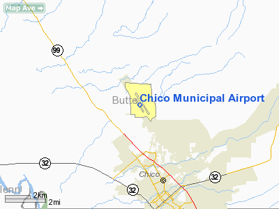
| Location |
Chico, California, 4 miles (6 km) N of downtown Chico |
| Elevation AMSL |
72.5 ft / m |
| Coordinates |
39°47′43″N 121°51′30″W / 39.79528°N 121.85833°W / 39.79528; -121.85833Coordinates: 39°47′43″N 121°51′30″W / 39.79528°N 121.85833°W / 39.79528; -121.85833 |
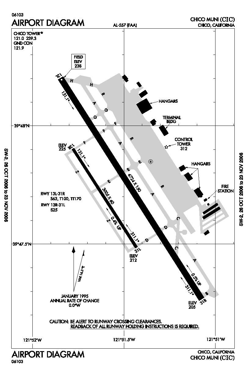
| Runways |
| Direction |
Length |
Surface |
| ft |
m |
| 13L/31R |
6,724 |
2,049 |
Asphalt |
| 13R/31L |
3,005 |
916 |
Asphalt |
| Helipads |
| Number |
Length |
Surface |
| ft |
m |
| H1 |
64 |
20 |
Concrete |
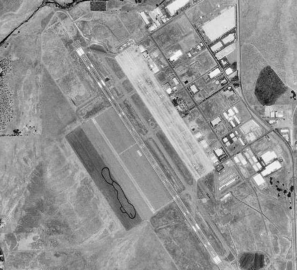
Chico Municipal Airport (IATA: CIC, ICAO: KCIC, FAA LID: CIC), often called CMA, is a public airport located four miles (6 km) north of the central business district (CBD) of Chico, a city in Butte County, California, United States. The airport covers 1,475 acres (6 km²) and has two runways and one helipad. It is mostly used for general aviation, but is served by one commercial airline. The airport's fixed base operator, "Northgate Aviation". http://www.northgateaviation.com. , provides fuel, maintenance, flight training and charter flights for business and personal travel. Airline and destination
| Airlines |
Destinations |
| United Express operated by SkyWest Airlines |
San Francisco |
History
During the late 1930s the City of Chico acquired approximately 160 acres (0.6 km²) of land five miles (8 km) north of what was then the City limits and constructed an airport hangar and runway. Until 1941, this original facility was leased to a fixed-base operator. During 1941 the City acquired an additional 1,000 acres (4 km²) for the purpose of leasing the Airport to the United States Government.
During World War II, the Airport was leased to the U.S. Government on a "Dollar a Year Lease" for the purpose of constructing and operating an United States Army Air Forces Basic Training Air Field. Chico Army Airfield was under the command of the 10th Army Air Force Base Unit, AAF West Coast Training Center, Fourth Air Force. Chico Army Airfield was a major training site for thousands of pilots, both as a primary training base flying BT-13s, and for advanced gunnery and multi-engine training in P-38, P-39, P-63, B-17, B-29s.
Chico AAF also had five auxiliary landing fields:
- Orland Auxiliary Field No. 1
- Kirkwood Auxiliary Field No. 2
- Vina Auxiliary Field No. 3
- Campbell Auxiliary Field No. 4
- Oroville Auxiliary Field No. 5
After the war, the City negotiated an agreement by which the airport property was returned to the City, together with the bulk of improvements which had been constructed by the Army.
A Titan-I ICBM was located on the north side of the airport from 1962–1965, part of the Beale AFB's 851st Strategic Missile Squadron system of several ICBMs centered around Marysville. Its formal designation was Beale 851-C. It is now dismantled.
Previous air carriers include American Eagle, Hughes Air West and Reno Air Express.
The above content comes from Wikipedia and is published under free licenses – click here to read more.
Location
& QuickFacts
|
FAA
Information Effective: |
2006-06-08 |
|
Airport
Identifier: |
CIC |
|
Longitude/Latitude: |
121-51-30.3230W/39-47-43.3780N
-121.858423/39.795383 (Estimated) |
|
Elevation: |
238 ft / 72.54 m (Surveyed) |
|
Land: |
1475 acres |
|
From
nearest city: |
4 nautical miles N of Chico, CA |
|
Location: |
Butte County, CA |
|
Magnetic Variation: |
16E (1990) |
Owner
& Manager
|
Ownership: |
Publicly owned |
|
Owner: |
City Of Chico
TOM LANDO |
|
Address: |
Po Box 3420
Chico, CA 95927 |
|
Phone number: |
530-895-4803 |
|
Manager: |
Robert Grierson |
|
Address: |
Po Box 3420
Chico, CA 95927 |
|
Phone number: |
530-895-4800 |
Airport
Operations and Facilities
|
Airport
Use: |
Open to public |
|
Wind
indicator: |
Yes |
|
Segmented
Circle: |
Yes |
|
Control
Tower: |
Yes |
|
Attendance
Schedule: |
ALL/ALL/0730-1930 |
|
Lighting
Schedule: |
DUSK-DAWN
WHEN ATCT CLSD ACTVT HIRL RY 13L/31R, VASI RY 31R, MALSR
& PAPI RY 13L - 121.0. |
|
Beacon
Color: |
Clear-Green (lighted land airport) |
|
Landing
fee charge: |
No |
|
Sectional
chart: |
San Francisco |
|
Region: |
AWP - Western-Pacific |
|
Boundary
ARTCC: |
ZOA - Oakland |
|
Tie-in
FSS: |
RIU - Rancho Murieta |
|
FSS
on Airport: |
No |
|
FSS
Phone: |
916-354-0161 |
|
FSS
Toll Free: |
1-800-WX-BRIEF |
|
NOTAMs
Facility: |
CIC (NOTAM-d service avaliable) |
|
Certification
type/date: |
I AU 5/1973
PPR FOR UNSKED ACR OPNS WITH MORE THAN 30 PSGR SEATS CALL
AMGR (530) 879-3910. |
|
Federal Agreements: |
NGPRY |
Airport
Communications
|
CTAF: |
121.000 |
|
Unicom: |
122.950 |
Airport
Services
|
Fuel
available: |
100LLA
FOR FUEL AFTER HRS CALL 530-540-8982. |
|
Airframe
Repair: |
MAJOR |
|
Power
Plant Repair: |
MAJOR |
|
Bottled
Oxygen: |
HIGH |
|
Runway
Information
Runway 13L/31R
|
Dimension: |
6724 x 150 ft / 2049.5 x 45.7 m |
|
Surface: |
ASPH, Good Condition |
|
Surface
Treatment: |
Saw-cut or plastic Grooved |
|
Weight
Limit: |
Single wheel: 63000 lbs.
Dual wheel: 100000 lbs.
Dual
tandem wheel: 170000 lbs. |
|
Edge
Lights: |
High |
|
|
Runway 13L |
Runway 31R |
|
Longitude: |
121-51-50.8290W |
121-51-04.4520W |
|
Latitude: |
39-48-12.1750N |
39-47-16.1780N |
|
Elevation: |
238.00 ft |
205.00 ft |
|
Alignment: |
127 |
127 |
|
ILS
Type: |
ILS |
|
|
Traffic
Pattern: |
Right |
Left |
|
Markings: |
Precision instrument, Good Condition |
Precision instrument, Good Condition |
|
Crossing
Height: |
52.00 ft |
50.00 ft |
|
VASI: |
2-light PAPI on left side |
4-box on left side |
|
Visual
Glide Angle: |
3.00� |
3.00� |
|
Approach
lights: |
MALSR |
|
|
Runway
End Identifier: |
No |
Yes |
|
Centerline
Lights: |
No |
No |
|
Touchdown
Lights: |
No |
No |
|
Runway 13R/31L
|
Dimension: |
3005 x 60 ft / 915.9 x 18.3 m |
|
Surface: |
ASPH, Fair Condition |
|
Weight
Limit: |
Single wheel: 25000 lbs. |
|
|
Runway 13R |
Runway 31L |
|
Longitude: |
121-51-46.5910W |
121-51-25.8760W |
|
Latitude: |
39-47-54.2250N |
39-47-29.1970N |
|
Elevation: |
225.00 ft |
212.00 ft |
|
Alignment: |
127 |
127 |
|
Traffic
Pattern: |
Right |
Left |
|
Markings: |
Basic, Good Condition |
Basic, Good Condition |
|
Runway
End Identifier: |
No |
No |
|
Centerline
Lights: |
No |
No |
|
Touchdown
Lights: |
No |
No |
|
Helipad H1
|
Dimension: |
64 x 64 ft / 19.5 x 19.5 m |
|
Surface: |
CONC, Good Condition |
|
Weight
Limit: |
Single wheel: 35000 lbs. |
|
|
Runway H1 |
Runway |
|
Traffic
Pattern: |
Left |
Left |
|
Radio Navigation
Aids
|
ID |
Type |
Name |
Ch |
Freq |
Var |
Dist |
|
OVE |
NDB |
Oroville |
|
212.00 |
16E |
21.1 nm |
|
PBT |
NDB |
Proberta |
|
338.00 |
16E |
25.9 nm |
|
MY |
NDB |
Halow |
|
222.00 |
16E |
39.4 nm |
|
BAB |
TACAN |
Beale |
023X |
|
16E |
44.2 nm |
|
CIC |
VOR/DME |
Chico |
035X |
109.80 |
16E |
0.6 nm |
|
MYV |
VOR/DME |
Marysville |
045X |
110.80 |
16E |
43.9 nm |
|
RDD |
VOR/DME |
Redding |
021X |
108.40 |
18E |
47.0 nm |
|
RBL |
VORTAC |
Red Bluff |
104X |
115.70 |
18E |
25.2 nm |
|
MXW |
VORTAC |
Maxwell |
037X |
110.00 |
18E |
33.3 nm |
|
ILA |
VORTAC |
Williams |
091X |
114.40 |
18E |
44.2 nm |
Remarks
- JET/HVY
ACFT OPER EAST OF FLD TPA 1500 FT AGL; LGT ACFT OPER WEST & EAST
OF FLD TPA 1000 FT AGL.
Based Aircraft
|
Aircraft
based on field: |
130 |
|
Single
Engine Airplanes: |
94 |
|
Multi
Engine Airplanes: |
33 |
|
Jet Engine
Airplanes: |
1 |
|
Helicopters: |
2 |
Major Carriers
Serving This Airport
Most Popular Destinations
| San Francisco International (SFO) |
100.0% |
Most Popular Aircraft
|
N234SW |
5.3% |
| N292SW |
4.9% |
|
N268UE |
3.8% |
| N299SW |
3.8% |
|
N579SW |
3.4% |
| N237SW |
3.4% |
|
N226SW |
3.0% |
| N232SW |
3.0% |
|
N301YV |
3.0% |
| N288SW |
2.6% |
Operational Statistics
|
Aircraft
Operations: |
137/Day |
|
Air Taxi: |
17.5% |
|
General
Aviation Local: |
21.0% |
|
General
Aviation Itinerant: |
59.6% |
|
Military: |
1.8% |
Chico Municipal Airport
Address:
Butte County, CA
Tel:
530-895-4803, 530-895-4800
Images
and information placed above are from
http://www.airport-data.com/airport/CIC/
We
thank them for the data!
| General
Info |
| Country |
United
States |
| State |
CALIFORNIA
|
| FAA ID |
CIC
|
| Latitude |
39-47-43.378N
|
| Longitude |
121-51-30.323W
|
| Elevation |
238 feet
|
| Near City |
CHICO
|
We don't guarantee the information is fresh and accurate. The data may
be wrong or outdated.
For more up-to-date information please refer to other sources.
|
|