 |
|
Chemehuevi Valley Airport |
| Chemehuevi Valley Airport |
| IATA: none – ICAO: none – FAA LID: 49X |
| Summary |
| Airport type |
Chemehuevi Indian Tribe |
| Operator |
Chemehuevi Valley, California |
| Location |
631 |
| Elevation AMSL |
192.3 ft / m |
| Coordinates |
34°31′39″N 114°25′52″W / 34.5275°N 114.43111°W / 34.5275; -114.43111Coordinates: 34°31′39″N 114°25′52″W / 34.5275°N 114.43111°W / 34.5275; -114.43111 |
| Runways |
| Direction |
Length |
Surface |
| ft |
m |
| 16/34 |
5,000 |
1,524 |
Asphalt |
Chemehuevi Valley Airport (FAA LID: 49X) is a public airport located four miles (6.4 km) north of Chemehuevi Valley, serving San Bernardino County, California, USA. The airport is mostly used for general aviation.
Facilities
Chemehuevi Valley Airport covers 144 acres (58 ha) and has one runway:
- Runway 16/34: 5,000 x 75 ft (1,524 × 23 m), Surface: Asphalt
The above content comes from Wikipedia and is published under free licenses – click here to read more.
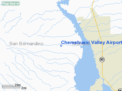
Location
& QuickFacts
|
FAA
Information Effective: |
2006-06-08 |
|
Airport
Identifier: |
49X |
|
Longitude/Latitude: |
114-25-51.8510W/34-31-39.0390N
-114.431070/34.527511 (Estimated) |
|
Elevation: |
631 ft / 192.33 m (Estimated) |
|
Land: |
144 acres |
|
From
nearest city: |
4 nautical miles N of Chemehuevi Valley,
CA |
|
Location: |
San Bernardino County, CA |
|
Magnetic Variation: |
13E (1985) |
Owner
& Manager
|
Ownership: |
Publicly owned |
|
Owner: |
Chemehuevi Indian Tribe |
|
Address: |
Po Box 1976
Havasu Lake, CA 92363 |
|
Phone
number: |
760-858-1116 |
|
Manager: |
William Cox |
|
Address: |
Po Box 1976
Havasu Lake, CA 92363 |
|
Phone number: |
760-858-1116 |
Airport
Operations and Facilities
|
Airport
Use: |
Open to public |
|
Wind
indicator: |
Yes |
|
Segmented
Circle: |
Yes |
|
Control
Tower: |
No |
|
Attendance
Schedule: |
UNATNDD |
|
Lighting
Schedule: |
DUSK-DAWN
ACTVT MIRL RY 16/34 - CTAF. |
|
Beacon
Color: |
Clear-Green (lighted land airport) |
|
Sectional
chart: |
Phoenix |
|
Region: |
AWP - Western-Pacific |
|
Boundary
ARTCC: |
ZLA - Los Angeles |
|
Tie-in
FSS: |
RAL - Riverside |
|
FSS
on Airport: |
No |
|
FSS
Phone: |
951-351-3020 |
|
FSS
Toll Free: |
1-800-WX-BRIEF |
|
NOTAMs
Facility: |
RAL (NOTAM-d service avaliable) |
|
Federal Agreements: |
NGY |
Airport
Communications
|
Runway Information
Runway 16/34
|
Dimension: |
5000 x 75 ft / 1524.0 x 22.9 m |
|
Surface: |
ASPH, Fair Condition |
|
Weight
Limit: |
Single wheel: 12000 lbs. |
|
Edge
Lights: |
Medium |
|
|
Runway 16 |
Runway 34 |
|
Traffic
Pattern: |
Left |
Left |
|
Markings: |
Basic, Good Condition |
Basic, Good Condition |
|
Obstruction: |
15 ft tree, 530.0 ft from runway, 84 ft left
of centerline, 22:1 slope to clear |
, 50:1 slope to clear |
|
Radio Navigation
Aids
|
ID |
Type |
Name |
Ch |
Freq |
Var |
Dist |
|
EED |
VORTAC |
Needles |
099X |
115.20 |
15E |
14.5 nm |
|
PKE |
VORTAC |
Parker |
126X |
117.90 |
15E |
28.5 nm |
Remarks
Based Aircraft
|
Aircraft
based on field: |
4 |
|
Single
Engine Airplanes: |
1 |
|
Multi
Engine Airplanes: |
3 |
Operational Statistics
|
Aircraft
Operations: |
77/Week |
|
General
Aviation Local: |
50.0% |
|
General
Aviation Itinerant: |
50.0% |
Chemehuevi Valley Airport
Address:
San Bernardino County, CA
Tel:
760-858-1116
Images
and information placed above are from
http://www.airport-data.com/airport/49X/
We
thank them for the data!
| General
Info |
| Country |
United
States |
| State |
CALIFORNIA
|
| FAA ID |
49X
|
| Latitude |
34-31-39.039N
|
| Longitude |
114-25-51.851W
|
| Elevation |
631 feet
|
| Near City |
CHEMEHUEVI
VALLEY |
We don't guarantee the information is fresh and accurate. The data may
be wrong or outdated.
For more up-to-date information please refer to other sources.
|
|


