Catalina Airport in California California airports - Catalina Airport
Catalina Airport in California - United States
California Airports
USA Airports
World Airports
Airport photos - free!
Aircraft photos - free!
Spacecraft pics - free!
Aviation Articles

Catalina Airport


Catalina Airport
Douglas DC-3 on take-off
Catalina Airport runway diagram
IATA: CIB – ICAO: KAVX – FAA LID: AVX
Summary
Airport type Public
Owner Catalina Island Conservancy
Serves Catalina Island
Location Avalon, California
Elevation AMSL 1,602 ft / 488 m
Coordinates 33°24′18″N 118°24′57″W / 33.405°N 118.41583°W / 33.405; -118.41583
Runways
Direction Length Surface
ft m
4/22 3,000 914 Asphalt
Statistics (2006)
Aircraft operations 23,000
Based aircraft 10
Source: Federal Aviation Administration

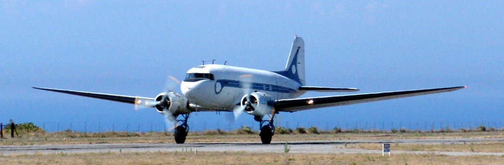
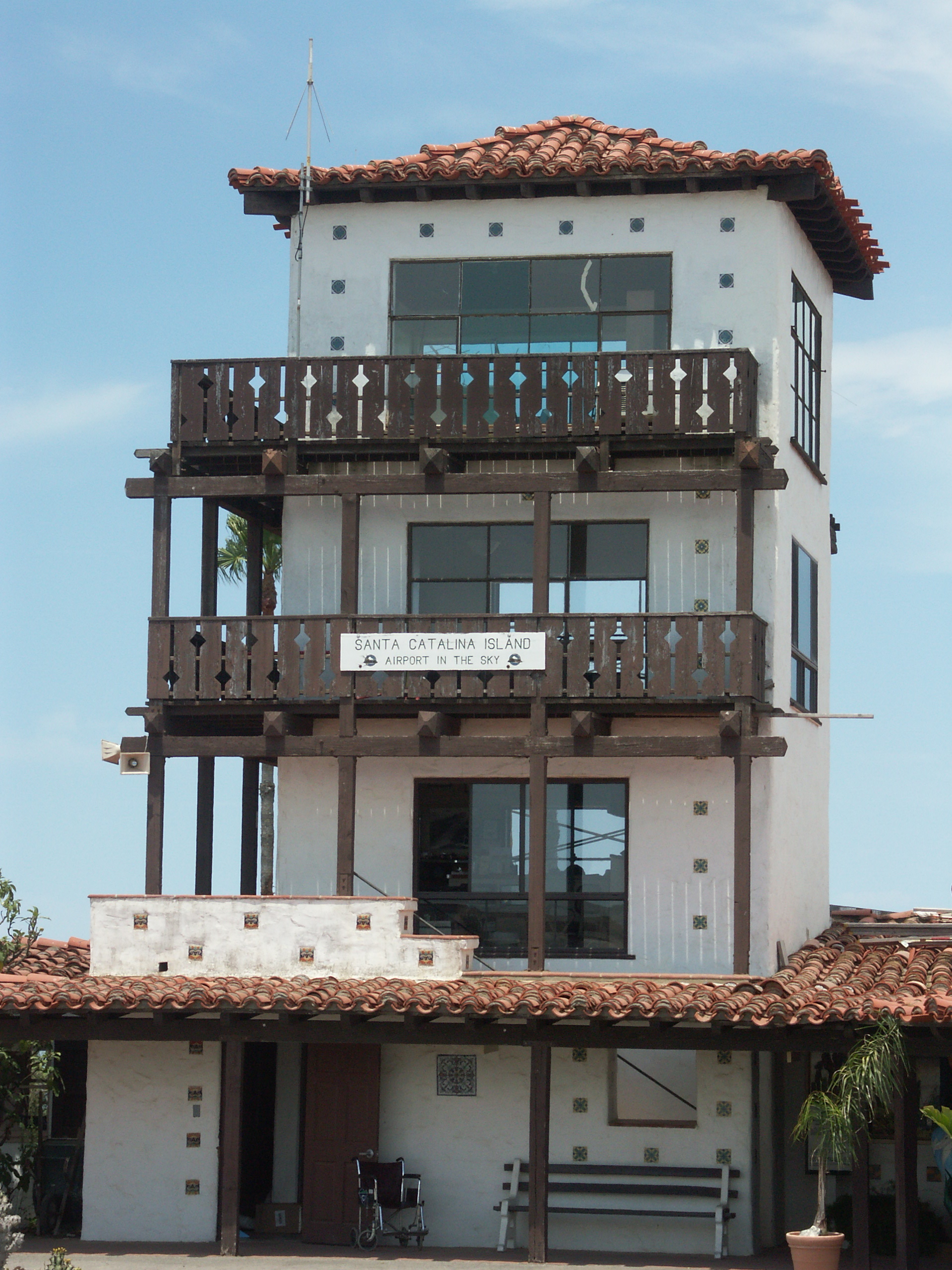
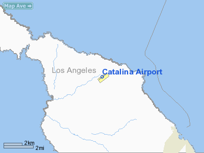
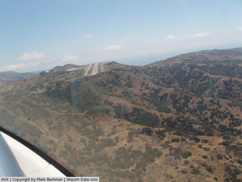
Catalina Airport (IATA: CIB, ICAO: KAVX, FAA LID: AVX) is a privately-owned airport located six miles (10 km) northwest of the central business district of Avalon, California in the middle of Catalina Island. The airport is open to the public and allows general aviation aircraft to land there. The only requirement is that inbound pilots state their intention to land and that they pay a $25.00 (US) landing fee. The airport is primarily used for general aviation. The airport is also used for airfreight from the mainland. Supplies for the island are delivered via Douglas DC-3 aircraft daily. There are no scheduled passenger flights to or from the airport. It is also known as the Airport in the Sky due to the fact it lies near the island's highest point at an elevation of 1,602 ft (488 m) All roads to the airport from the island's population centers climb steeply upward.

Although most U.S. airports use the same three-letter location identifier for the FAA and IATA, Catalina Airport is assigned AVX by the FAA and CIB by the IATA. The airport's ICAO identifier is KAVX.

There is a restaurant at the airport, the Buffalo Springs Station restaurant, and for private pilots in the Los Angeles area, the airport is one local choice for a $100 Hamburger (aviation slang for a private general aviation flight for the sole purpose of dining at a non-local airport). The restaurant and airport is also a stop on some of the tours of the interior of Catalina Island from Avalon.

The airport originally opened as "Buffalo Springs Airport" in the late 1930s and was made by leveling off the top of a hill. Scheduled passenger service was briefly provided by United Airlines in DC-3s; long-disused refueling equipment is located in the pavement in front of the terminal building; no fuel currently available. The Wrigley family - who owned Santa Catalina Island for decades - used to keep their DC-3 in the large hangar at the airport.

Facilities and aircraft

Catalina Airport covers 25 acres (100,000 m) and has one asphalt runway (4/22) measuring 3,000 x 75 feet (914 x 23 m). Surface elevation of the runway is 1602 feet (488 m) above sea level. The runway is known for being pitched up in the middle, so that on short approach it appears much shorter. Pavement condition varies widely; after recent maintenance it is good, but following the rainy season there are often potholes, soft spots, and chunks of loose asphalt on the runway. Terrain falls off steeply at both ends of the runway. Due to turbulence and downdrafts at the approach ends, lack of normal visual references on final approach, and the upslope of the first 1/3 of Runway 22 (which creates the illusion of being too high on final approach) the airport can be hazardous for inexperienced pilots. Aircraft at opposite ends of the runway cannot see each other. Contact with UNICOM is required to obtain permission for landing.

Catalina Island gets rave reviews from visiting pilots, but pilot reviews of the attitudes of staffers in and around the airport are mixed.

For 12-month period ending April 13, 2006, the airport had 23,000 aircraft operations, an average of 63 per day: 98% general aviation (22,450), 2% air taxi (500) and <1% military (50). There are 10 aircraft based at this airport, all single-engine.


The tower in 2005
The tower in 2005


The above content comes from Wikipedia and is published under free licenses – click here to read more.

Catalina Airport picture

Catalina Airport picture
(Click on the photo to enlarge)


Location & QuickFacts

FAA Information Effective:

2006-06-08

Airport Identifier:

AVX

Longitude/Latitude:

118-24-57.1000W/33-24-17.8000N
-118.415861/33.404944 (Estimated)

Elevation:

1602 ft / 488.29 m (Surveyed)

Land:

25 acres

From nearest city:

6 nautical miles NW of Avalon, CA

Location:

Los Angeles County, CA

Magnetic Variation:

14E (1985)

Owner & Manager

Ownership:

Privately owned

Owner:

Santa Catalina Is Conservancy

Address:

Box 2739
Avalon, CA 90704

Phone number:

310-510-1421

Manager:

Paul Moritz

Address:

Box 2739
Avalon, CA 90704

Phone number:

310-510-0143

Airport Operations and Facilities

Airport Use:

Open to public

Wind indicator:

Yes

Segmented Circle:

Yes

Control Tower:

No

Attendance Schedule:

APR 15-OCT 15/ALL/0800-1900,OCT 16-APR 14/ALL/0800-1700

Lighting Schedule:

PHONE REQ
NSTD RY LGTS FOR EMERG USE ONLY CALL (310) 510-0143.

Landing fee charge:

Yes

Sectional chart:

Los Angeles

Region:

AWP - Western-Pacific

Traffic Pattern Alt:

1000 ft

Boundary ARTCC:

ZLA - Los Angeles

Tie-in FSS:

HHR - Hawthorne

FSS on Airport:

No

FSS Phone:

310-970-0102

FSS Toll Free:

1-800-WX-BRIEF

NOTAMs Facility:

AVX (NOTAM-d service avaliable)

Federal Agreements:

N

Airport Communications

CTAF:

122.700

Unicom:

122.700 

Airport Services

Airframe Repair:

NONE

Power Plant Repair:

NONE

Bottled Oxygen:

NONE

Bulk Oxygen:

NONE


Runway Information

Runway 04/22

Dimension:

3000 x 75 ft / 914.4 x 22.9 m

Surface:

ASPH, Poor Condition
POTHOLES AND LOOSE PAVEMENT FRAGMENTS ON RY.

Edge Lights:

Non-standard lighting system
NSTD MIRL 2971 FT LIGHTED BTN THLDS ONLY.


Runway 04

Runway 22

Longitude:

118-25-12.3910W

118-24-41.8870W

Latitude:

33-24-08.7610N

33-24-26.7890N

Elevation:

1601.00 ft

1547.00 ft

Alignment:

55

127

Traffic Pattern:

Left

Right

Markings:

Basic, Fair Condition

Basic, Good Condition

VASI:


pulsating/steady burning on left side

Visual Glide Angle:

0.00°

3.00°

Runway End Identifier:

No

Yes


Radio Navigation Aids

ID

Type

Name

Ch

Freq

Var

Dist

NUC

NDB

San Clemente


350.00

15E

24.0 nm

CPM

NDB

Compton


378.00

15E

30.3 nm

EMT

NDB

El Monte


359.00

15E

45.4 nm

NUC

TACAN

San Clemente

123X


15E

24.2 nm

SMO

VOR/DME

Santa Monica

045X

110.80

15E

36.4 nm

ELB

VOR/DME

El Toro

119X

117.20

14E

38.0 nm

VNY

VOR/DME

Van Nuys

078X

113.10

15E

49.3 nm

SXC

VORTAC

Santa Catalina

051X

111.40

15E

1.8 nm

SLI

VORTAC

Seal Beach

104X

115.70

15E

29.1 nm

LAX

VORTAC

Los Angeles

083X

113.60

15E

31.8 nm

LAX

VOT

San Pedro Hill


113.90


20.9 nm

SNA

VOT

Santa Ana


110.00


31.9 nm

Remarks

  • FULL STOP LNDGS ONLY; INTXN TKOFS PROHIBITED.
  • < OR TKOF TO PRIOR UNICOM THRU RQRD APVL USE, PUBLIC>
  • ARPT CLOSED FOR ALL OPERATIONS OTHER THAN DURING PUBLISHED OPERATING HOURS EXCEPT FOR EMERGENCY.
  • FIRST 2000' OF RWY 22 SLOPES UP 1.69%; REMAINDER OF RWY LEVEL.
  • PILOTS CANNOT SEE ACFT ON OPPOSITE ENDS OF RWY.
  • SFC ROUGH WITH NMRS POTHOLES & SOFT SPOTS.
  • RY 04/22 SAFETY AREAS BOTH ENDS, 1600 FT + DROPOFFS TO THE SEA.
  • RY 04/22 LIMITED BY AIRPORT OPERATOR TO 12,500 LBS GWT.
  • ESTABD PRIOR TO 1959.


Based Aircraft

Aircraft based on field:

10

Single Engine Airplanes:

10

Operational Statistics

Aircraft Operations:

64/Day

Air Taxi:

2.2%

General Aviation Local:

4.9%

General Aviation Itinerant:

92.7%

Military:

0.2%


Catalina Airport  

Address: Los Angeles County, CA

Tel: 310-510-1421, 310-510-0143


Images and information placed above are from
http://www.airport-data.com/airport/AVX/

We thank them for the data!


General Info
Country United States
State CALIFORNIA
FAA ID AVX
Latitude 33-24-17.800N
Longitude 118-24-57.100W
Elevation 1602 feet
Near City AVALON


We don't guarantee the information is fresh and accurate. The data may be wrong or outdated.
For more up-to-date information please refer to other sources.


christianity portal
directory of hotels worldwide


Copyright 2004-2024 © by Airports-Worldwide.com, Vyshenskoho st. 36, Lviv 79010, Ukraine
Legal Disclaimer