|
|
California City Municipal Airport |
| California City Municipal Airport |
 |
| IATA: none – ICAO: none – FAA LID: L71 |
| Summary |
| Airport type |
City of California City |
| Operator |
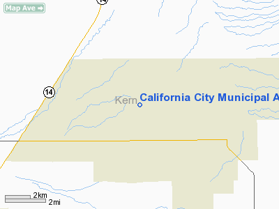
California City, California |
| Location |
2,454 |
| Elevation AMSL |
748 ft / m |
| Coordinates |
35°09′04″N 118°01′00″W / 35.15111°N 118.0166667°W / 35.15111; -118.0166667Coordinates: 35°09′04″N 118°01′00″W / 35.15111°N 118.0166667°W / 35.15111; -118.0166667 |
| Runways |
| Direction |
Length |
Surface |
| ft |
m |
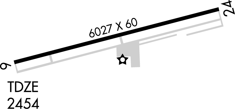
| 6/24 |
6,027 |
1,837 |
Asphalt |
California City Municipal Airport (FAA LID: L71) is located two miles (3 km) northwest of the central business district (CBD) of California City, in the Fremont Valley of Kern County, California, USA. The airport is open to the public, and lies at an elevation of 2,450 feet (750 m) above sea level.
Facilities
California City Municipal Airport covers 245 acres (99 ha) and has one runway:
- Runway 6/24: 6,027 x 60 ft (1,837 x 18 m), Surface: Asphalt
The above content comes from Wikipedia and is published under free licenses – click here to read more.
Location
& QuickFacts
|
FAA
Information Effective: |
2006-06-08 |
|
Airport
Identifier: |
L71 |
|
Longitude/Latitude: |
118-01-00.0000W/35-09-04.5000N
-118.016667/35.151250 (Estimated) |
|
Elevation: |
2454 ft / 747.98 m (Surveyed) |
|
Land: |
245 acres |
|
From
nearest city: |
2 nautical miles NW of California City, CA |
|
Location: |
Kern County, CA |
|
Magnetic Variation: |
14E (2005) |
Owner
& Manager
|
Ownership: |
Publicly owned |
|
Owner: |
City Of California City |
|
Address: |
21000 Hacienda Blvd
California City, CA 93505 |
|
Phone
number: |
760-373-8661 |
|
Manager: |
Tom Weil |
|
Address: |
22636 Airport Way
California City, CA 93505 |
|
Phone number: |
760-373-4867 |
Airport
Operations and Facilities
|
Airport
Use: |
Open to public |
|
Wind
indicator: |
Yes |
|
Segmented
Circle: |
Yes |
|
Control
Tower: |
No |
|
Attendance
Schedule: |
ALL/ALL/0800-1700 |
|
Lighting
Schedule: |
DUSK-DAWN
ACTVT MIRL RY 06/24 - CTAF. |
|
Beacon
Color: |
Clear-Green (lighted land airport) |
|
Landing
fee charge: |
No |
|
Sectional
chart: |
Los Angeles |
|
Region: |
AWP - Western-Pacific |
|
Traffic
Pattern Alt: |
1000 ft |
|
Boundary
ARTCC: |
ZLA - Los Angeles |
|
Tie-in
FSS: |
RAL - Riverside |
|
FSS
on Airport: |
No |
|
FSS
Phone: |
951-351-3020 |
|
FSS
Toll Free: |
1-800-WX-BRIEF |
|
NOTAMs
Facility: |
RAL (NOTAM-d service avaliable) |
|
Federal Agreements: |
N |
Airport
Communications
|
CTAF: |
122.700 |
|
Unicom: |
122.700 |
Airport
Services
|
Fuel
available: |
100LL80 A |
|
Airframe
Repair: |
MINOR |
|
Power
Plant Repair: |
MINOR |
|
Bottled
Oxygen: |
LOW |
|
Runway Information
Runway 06/24
|
Dimension: |
6027 x 60 ft / 1837.0 x 18.3 m |
|
Surface: |
ASPH, Good Condition |
|
Weight
Limit: |
Single wheel: 26000 lbs. |
|
Edge
Lights: |
Medium |
|
|
Runway 06 |
Runway 24 |
|
Longitude: |
118-01-35.1130W |
118-00-24.8444W |
|
Latitude: |
35-08-57.0641N |
35-09-11.9351N |
|
Elevation: |
2454.00 ft |
2401.00 ft |
|
Alignment: |
75 |
127 |
|
Traffic
Pattern: |
Left |
Right |
|
Markings: |
Basic, Good Condition |
Basic, Good Condition |
|
Runway
End Identifier: |
No |
No |
|
Centerline
Lights: |
No |
No |
|
Touchdown
Lights: |
No |
No |
|
Radio Navigation
Aids
|
ID |
Type |
Name |
Ch |
Freq |
Var |
Dist |
|
GWF |
NDB |
Gen William J Fox |
|
282.00 |
15E |
26.7 nm |
|
NID |
TACAN |
China Lake |
053X |
|
16E |
36.0 nm |
|
VCV |
VOR/DME |
Victorville |
031X |
109.40 |
14E |
45.6 nm |
|
EDW |
VORTAC |
Edwards |
111X |
116.40 |
15E |
17.3 nm |
|
PMD |
VORTAC |
Palmdale |
092X |
114.50 |
15E |
31.3 nm |
|
LHS |
VORTAC |
Lake Hughes |
021X |
108.40 |
15E |
39.4 nm |
|
GMN |
VORTAC |
Gorman |
108X |
116.10 |
16E |
46.5 nm |
Remarks
- TWO
DIRT GLIDER LNDG STRIPS 2000' X 150' AND 1600' X 150' ARE CONSTRUCTED
325' S OF 06/24 CNTRLN. EAST
STRIP PAVED 1000' X 30.
- EXTNSV
GLIDER TFC AND SKY DIVING ACTIVITY DAILY.
- RY
06/24 PAEW ADJ RY 0700-1500 DLY.
- VFR
CONDITIONS ONLY.
Based Aircraft
|
Aircraft
based on field: |
91 |
|
Single
Engine Airplanes: |
26 |
|
Multi
Engine Airplanes: |
4 |
|
Jet Engine
Airplanes: |
5 |
|
Gliders: |
53 |
|
Ultralights: |
3 |
Operational Statistics
|
Aircraft
Operations: |
102/Day |
|
General
Aviation Local: |
32.3% |
|
General
Aviation Itinerant: |
67.2% |
|
Military: |
0.5% |
California City Municipal Airport
Address:
Kern County, CA
Tel:
760-373-8661,
760-373-4867
Images
and information placed above are from
http://www.airport-data.com/airport/L71/
We
thank them for the data!
| General
Info |
| Country |
United
States |
| State |
CALIFORNIA
|
| FAA ID |
L71
|
| Latitude |
35-09-04.511N
|
| Longitude |
118-01-00.000W
|
| Elevation |
2450 feet
|
| Near City |
CALIFORNIA
CITY |
We don't guarantee the information is fresh and accurate. The data may
be wrong or outdated.
For more up-to-date information please refer to other sources.
|
|