|
|
Calaveras Co-maury Rasmussen Field Airport |
Calaveras County Airport
Maury Rasmussen Field |
| IATA: none – ICAO: KCPU – FAA LID: CPU |
| Summary |
| Airport type |
Public |
| Owner |
County of Calaveras |
| Location |
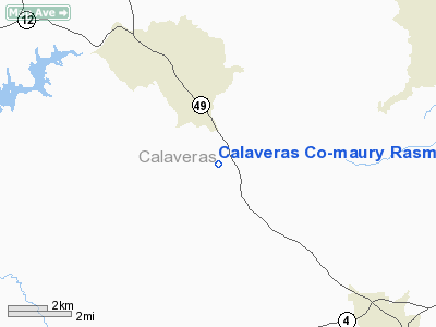
San Andreas, California |
| Elevation AMSL |
1,325 ft / 404 m |
| Coordinates |
38°08′46″N 120°38′53″W / 38.14611°N 120.64806°W / 38.14611; -120.64806 |
| Runways |
| Direction |
Length |
Surface |
| ft |
m |
| 13/31 |
3,603 |
1,098 |
Asphalt |
| Helipads |
| Number |
Length |
Surface |
| ft |
m |
| H1 |
65 |
20 |
Asphalt |
| H2 |
65 |
20 |
Asphalt |
| Statistics (2005) |
| Aircraft operations |
25,000 |
| Based aircraft |
79 |
| Source: Federal Aviation Administration |
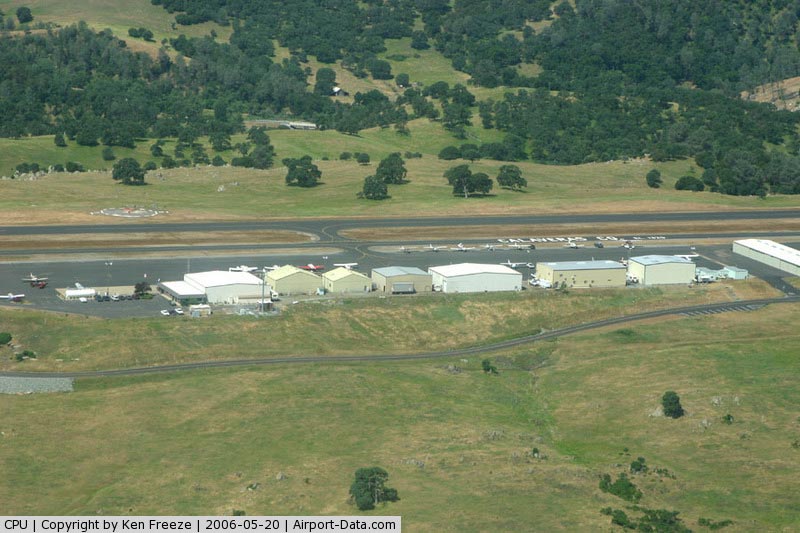
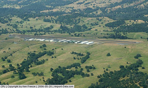
Calaveras County Airport (ICAO: KCPU, FAA LID: CPU), also known as Maury Rasmussen Field, is a public airport located four miles (6 km) southeast of the central business district of San Andreas, in Calaveras County, California, United States. It is owned by the County of Calaveras.
Although most U.S. airports use the same three-letter location identifier for the FAA and IATA, Calaveras County Airport is assigned CPU by the FAA but has no designation from the IATA (which assigned CPU to Cururupu, Maranhão, Brazil).
Facilities and aircraft
Calaveras County Airport covers an area of 93 acres (38 ha) which contains one runway (13/31: 3,603 x 60 ft.) and two helipads (both 65 x 65 ft.).
For the 12-month period ending September 21, 2005, the airport had 25,000 aircraft operations, an average of 68 per day, all of which were general aviation. There are 79 aircraft based at this airport: 98% single engine, 1% multi-engine and 1% ultralight.
The above content comes from Wikipedia and is published under free licenses – click here to read more.
|
 |
(Click on the photo to enlarge) |
|
 |
(Click on the photo to enlarge) |
Location
& QuickFacts
|
FAA
Information Effective: |
2006-06-08 |
|
Airport
Identifier: |
CPU |
|
Longitude/Latitude: |
120-38-53.4240W/38-08-46.0190N
-120.648173/38.146116 (Estimated) |
|
Elevation: |
1325 ft / 403.86 m (Surveyed) |
|
Land: |
93 acres |
|
From
nearest city: |
4 nautical miles SE of San Andreas, CA |
|
Location: |
Calaveras County, CA |
|
Magnetic Variation: |
15E (1995) |
Owner
& Manager
|
Ownership: |
Publicly owned |
|
Owner: |
County Of Calaveras |
|
Address: |
Government Center
San Andreas, CA 95249 |
|
Phone
number: |
209-754-2501 |
|
Manager: |
Kathy Zancanella |
|
Address: |
Po Box 112
San Andreas, CA 95249-0815 |
|
Phone number: |
209-754-2501 |
Airport
Operations and Facilities
|
Airport
Use: |
Open to public |
|
Wind
indicator: |
Yes |
|
Segmented
Circle: |
Yes |
|
Control
Tower: |
No |
|
Attendance
Schedule: |
NOV-APR/ALL/0800-1700,MAY-OCT/ALL/0700-1800
FOR ATTENDANT AFT HRS CALL 209-736-2501 OR 209-754-4220. |
|
Lighting
Schedule: |
DUSK-DAWN
MIRL RY 13/31 OPERS DUSK-0000; AFT 0000 ACTVT MIRL - CTAF;
ACTVT VASI RY 31 - CTAF. |
|
Beacon
Color: |
Clear-Green (lighted land airport) |
|
Landing
fee charge: |
No |
|
Sectional
chart: |
San Francisco |
|
Region: |
AWP - Western-Pacific |
|
Boundary
ARTCC: |
ZOA - Oakland |
|
Tie-in
FSS: |
RIU - Rancho Murieta |
|
FSS
on Airport: |
No |
|
FSS
Phone: |
916-354-0161 |
|
FSS
Toll Free: |
1-800-WX-BRIEF |
|
NOTAMs
Facility: |
RIU (NOTAM-d service avaliable) |
|
Federal Agreements: |
NGY |
Airport
Communications
|
CTAF: |
122.800 |
|
Unicom: |
122.800 |
Airport
Services
|
Fuel
available: |
100LL80 |
|
Airframe
Repair: |
MAJOR |
|
Power
Plant Repair: |
MAJOR |
|
Runway Information
Runway 13/31
|
Dimension: |
3603 x 60 ft / 1098.2 x 18.3 m |
|
Surface: |
ASPH, Good Condition |
|
Weight
Limit: |
Single wheel: 12500 lbs. |
|
Edge
Lights: |
Medium |
|
|
Runway 13 |
Runway 31 |
|
Longitude: |
120-39-06.0730W |
120-38-40.7770W |
|
Latitude: |
38-09-00.7580N |
38-08-31.2790N |
|
Elevation: |
1302.00 ft |
1325.00 ft |
|
Alignment: |
127 |
127 |
|
Traffic
Pattern: |
Left |
Right |
|
Markings: |
Basic, Good Condition |
Basic, Good Condition |
|
Crossing
Height: |
0.00 ft |
31.00 ft |
|
VASI: |
|
4-box on right side |
|
Visual
Glide Angle: |
0.00� |
3.00� |
|
Obstruction: |
15 ft tree, 660.0 ft from runway, 150 ft left
of centerline, 30:1 slope to clear |
, 50:1 slope to clear |
|
Helipad H1
|
Dimension: |
65 x 65 ft / 19.8 x 19.8 m |
|
Surface: |
ASPH, Good Condition |
|
|
Runway H1 |
Runway |
|
Traffic
Pattern: |
Left |
Left |
|
Helipad H2
|
Dimension: |
65 x 65 ft / 19.8 x 19.8 m |
|
Surface: |
ASPH, Good Condition |
|
|
Runway H2 |
Runway |
|
Traffic
Pattern: |
Left |
Left |
|
Radio Navigation
Aids
|
ID |
Type |
Name |
Ch |
Freq |
Var |
Dist |
|
TCY |
NDB |
Tracy |
|
203.00 |
15E |
46.6 nm |
|
MOD |
VOR/DME |
Modesto |
093X |
114.60 |
17E |
34.5 nm |
|
HNW |
VOR/DME |
Hangtown |
102X |
115.50 |
17E |
35.1 nm |
|
MCC |
VOR/DME |
Mc Clellan |
029X |
109.20 |
17E |
47.4 nm |
|
LIN |
VORTAC |
Linden |
095X |
114.80 |
17E |
17.4 nm |
|
ECA |
VORTAC |
Manteca |
107X |
116.00 |
17E |
31.1 nm |
|
SAC |
VORTAC |
Sacramento |
099X |
115.20 |
17E |
46.2 nm |
|
SAC |
VOT |
Sacramento Executive |
|
111.40 |
|
45.8 nm |
Remarks
- EFFECTIVE
RY GRADIENT RY 13 0.6% UP.
- HELICOPTER
PARKING POSITIONS SOUTHEAST CORNER OF AIRPORT
Based Aircraft
|
Aircraft
based on field: |
79 |
|
Single
Engine Airplanes: |
77 |
|
Multi
Engine Airplanes: |
1 |
|
Ultralights: |
1 |
Operational Statistics
|
Aircraft
Operations: |
69/Day |
|
General
Aviation Local: |
60.0% |
|
General
Aviation Itinerant: |
40.0% |
Calaveras Co-maury Rasmussen Field Airport
Address:
Calaveras County, CA
Tel:
209-754-2501
Images
and information placed above are from
http://www.airport-data.com/airport/CPU/
We
thank them for the data!
| General
Info |
| Country |
United
States |
| State |
CALIFORNIA
|
| FAA ID |
CPU
|
| Latitude |
38-08-46.019N
|
| Longitude |
120-38-53.424W
|
| Elevation |
1325 feet
|
| Near City |
SAN ANDREAS
|
We don't guarantee the information is fresh and accurate. The data may
be wrong or outdated.
For more up-to-date information please refer to other sources.
|
|