|
|
Brown Field Municipal Airport |
| Brown Field Municipal Airport |
 |
| IATA: SDM – ICAO: KSDM – FAA LID: SDM |
| Summary |
| Airport type |
Public |
| Operator |
City of San Diego |
| Serves |
San Diego, California |
| Elevation AMSL |
526 ft / 160 m |
| Coordinates |
32°34′20″N 116°58′49″W / 32.57222°N 116.98028°W / 32.57222; -116.98028 |
| Website |
www.sandiego.gov |
| Runways |
| Direction |
Length |
Surface |
| ft |
m |
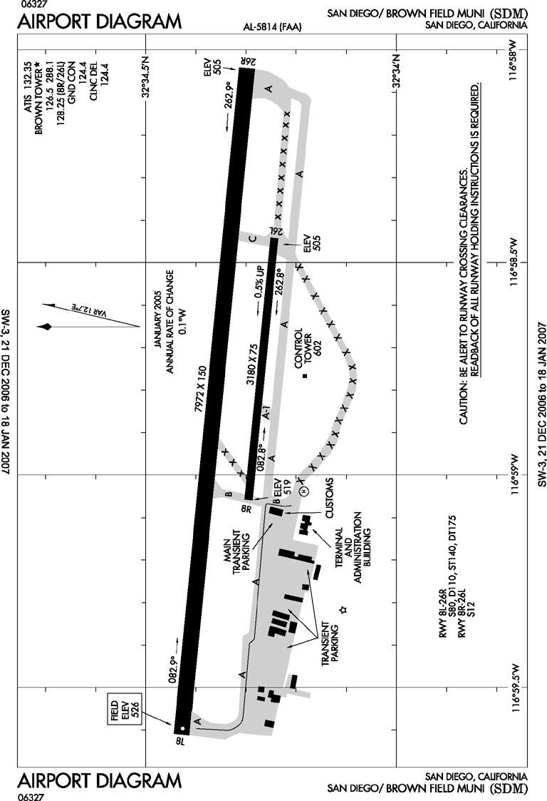
| 8L/26R |
7,972 |
2,430 |
Asphalt/Concrete |
| 8R/26L |
3,180 |
969 |
Asphalt |
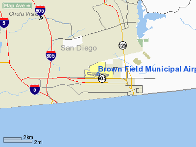
Brown Field Municipal Airport (IATA: SDM, ICAO: KSDM, FAA LID: SDM) is located in San Diego, California, 13 miles (21 kilometers) southeast of Downtown San Diego and named in honor of United States Navy Commander Melville S. Brown, who was killed in an airplane crash in 1936. Its FAA/IATA airport code of SDM probably comes from "San Diego Municipal". Formerly a Naval Auxiliary Air Station (NAAS), it is now a port of entry from Mexico. It is sometimes staffed by the U.S. Customs Service, but only upon the request of incoming pilots to the FAA.
It first opened in 1918 as East Field, later becoming NAAS Otay Mesa and then NAAS Brown Field, both in 1943. It was last used by the U.S. Navy in 1962, before becoming converted for general aviation use. Its primary runway is 7,972 feet (2,430 m) long. Caveat
Tijuana Airport is just over 1 nmi (1.9 km) to the south, with a similar length and a slightly different runway orientation (09 / 27) but is clearly a commercial passenger facility.
In addition, a precision approach is not possible to either runway end due to steep, rising terrain (elevation 3,600-feet) less than six miles (10 km) east of the airport. There have been several crashes due to pilots not maintaining sufficient altitude over these nearby mountains (often flying VFR at night).
Notable accidents
- March 16, 1991, Seven members of Reba McEntire's band and her road manager were among 10 people who died in the crash of a plane that departed from Brown Field. The aircraft impacted terrain on Otay Mountain northeast of the airport.
The above content comes from Wikipedia and is published under free licenses – click here to read more.
Location
& QuickFacts
|
FAA
Information Effective: |
2006-06-08 |
|
Airport
Identifier: |
SDM |
|
Longitude/Latitude: |
116-58-48.5800W/32-34-20.1800N
-116.980161/32.572272 (Estimated) |
|
Elevation: |
526 ft / 160.32 m (Surveyed) |
|
Land: |
899 acres |
|
From
nearest city: |
13 nautical miles SE of San Diego, CA |
|
Location: |
San Diego County, CA |
|
Magnetic Variation: |
13E (1985) |
Owner
& Manager
|
Ownership: |
Publicly owned |
|
Owner: |
City Of San Diego |
|
Address: |
1424 Continental St
San Diego, CA 92154 |
|
Phone
number: |
619-424-0456 |
|
Manager: |
Phillip Miller |
|
Address: |
1424 Continental St
San Diego, CA 92154 |
|
Phone number: |
619-424-0456 |
Airport
Operations and Facilities
|
Airport
Use: |
Open to public |
|
Wind
indicator: |
Yes |
|
Segmented
Circle: |
Yes |
|
Control
Tower: |
Yes |
|
Attendance
Schedule: |
ALL/M-F/0800-2000, CLSD WKENDS |
|
Lighting
Schedule: |
DUSK-DAWN |
|
Beacon
Color: |
Clear-Green (lighted land airport) |
|
Landing
fee charge: |
No |
|
Sectional
chart: |
Los Angeles |
|
Region: |
AWP - Western-Pacific |
|
Boundary
ARTCC: |
ZLA - Los Angeles |
|
Tie-in
FSS: |
SAN - San Diego |
|
FSS
on Airport: |
No |
|
FSS
Phone: |
858-277-7043 |
|
FSS
Toll Free: |
1-800-WX-BRIEF |
|
NOTAMs
Facility: |
SDM (NOTAM-d service avaliable) |
|
Federal Agreements: |
NGPY |
Airport
Communications
|
CTAF: |
126.500 |
|
Unicom: |
122.950 |
Airport
Services
|
Fuel
available: |
100LLA
FOR FUEL AFT HRS CALL FBO'S AT (619) 671-9222; FEE FOR CALLOUT.
MILITARY
FUEL AVBL BY CALLING (619) 671-9222. |
|
Airframe
Repair: |
MAJOR |
|
Power
Plant Repair: |
MAJOR |
|
Bottled
Oxygen: |
NONE |
|
Bulk
Oxygen: |
HIGH/LOW |
|
Runway Information
Runway 08L/26R
|
Dimension: |
7972 x 150 ft / 2429.9 x 45.7 m |
|
Surface: |
ASPH-CONC, Good Condition |
|
Weight
Limit: |
Single wheel: 80000 lbs.
Dual wheel: 110000 lbs.
Dual tandem wheel: 175000 lbs.
OPERATOR PERMITS ONLY 12000 LBS. |
|
Edge
Lights: |
Medium |
|
|
Runway 08L |
Runway 26R |
|
Longitude: |
116-59-36.3200W |
116-58-03.6090W |
|
Latitude: |
32-34-25.6400N |
32-34-17.9380N |
|
Elevation: |
526.00 ft |
508.00 ft |
|
Alignment: |
96 |
127 |
|
Traffic
Pattern: |
Left |
Right |
|
Markings: |
Non-precision instrument, Good Condition |
Non-precision instrument, Good Condition |
|
Runway
End Identifier: |
|
No |
|
Centerline
Lights: |
|
No |
|
Touchdown
Lights: |
|
No |
|
Runway 08R/26L
|
Dimension: |
3180 x 75 ft / 969.3 x 22.9 m |
|
Surface: |
ASPH, Good Condition |
|
Weight
Limit: |
Single wheel: 14000 lbs.
OPERATOR PERMITS ONLY 12000 LBS. |
|
|
Runway 08R |
Runway 26L |
|
Longitude: |
116-59-03.5966W |
116-58-26.6100W |
|
Latitude: |
32-34-17.6938N |
32-34-14.6300N |
|
Elevation: |
521.00 ft |
505.00 ft |
|
Alignment: |
96 |
127 |
|
Traffic
Pattern: |
Right |
Left |
|
Markings: |
Basic, Good Condition |
Basic, Good Condition |
|
Radio Navigation
Aids
|
ID |
Type |
Name |
Ch |
Freq |
Var |
Dist |
|
SAN |
FAN MARKER |
Encat |
|
|
15E |
10.0 nm |
|
UN |
NDB |
Tijuana |
|
381.00 |
14E |
3.6 nm |
|
NRS |
TACAN |
Imperial Beach |
029X |
|
14E |
6.6 nm |
|
NZY |
TACAN |
North Island |
117X |
|
14E |
14.3 nm |
|
NKX |
TACAN |
Miramar |
033X |
|
15E |
19.9 nm |
|
NFG |
TACAN |
Camp Pendleton |
055X |
|
13E |
46.9 nm |
|
NKX |
UHF/NDB |
Miramar |
|
352.00 |
15E |
19.9 nm |
|
TIJ |
VOR/DME |
Tijuana |
112X |
116.50 |
14E |
2.4 nm |
|
PGY |
VORTAC |
Poggi |
035X |
109.80 |
14E |
2.3 nm |
|
MZB |
VORTAC |
Mission Bay |
125X |
117.80 |
15E |
17.7 nm |
|
JLI |
VORTAC |
Julian |
087X |
114.00 |
15E |
39.5 nm |
|
OCN |
VORTAC |
Oceanside |
100X |
115.30 |
15E |
45.8 nm |
|
SEE |
VOT |
Gillespie Field |
|
110.00 |
|
15.2 nm |
|
SAN |
VOT |
Mount Soledad |
|
109.00 |
|
21.2 nm |
Remarks
- CAUTION:
ARPT BDRY ONE MILE NORTH FM MEXICAN/USA INTL BORDER.
- RY
08R/26L DALGT HRS ONLY.
- NO
OVERFLIGHT OF SURFACE ANTENNA ARRAY BELOW 1,500 FT. ANTENNA ARRAY LCTD
1,600 FT NORTH OF RY 26R.
- PARA
JUMPING ON AIRPORT AND 3 MILES EAST.
- BE
ALERT TO HIGH TERRAIN 3,566 FT. MSL SIX MILES EAST OF AIRPORT.
- CAUTION
ADVISED WHEN DEPARTING ON RY 08L AT NIGHT DUE TO RISING TERRAIN TO THE
EAST.
- NOISE
SENSITIVE AREA APPROX 2 MILES WEST OF AIRPORT.
- CAUTION
ADVISED DUE TO POSSIBLE UNAUTHORIZED PEDESTRIAN TRAFFIC CROSSING RWYS/TWYS.
- NO
ENGINE OPNS ON RAMPS EXCEPT AS NECESSARY FOR ARRIVALS/DEPARTURES.
- TWY
C CLSD SOUTH OF TWY A INDEFLY.
Based Aircraft
|
Aircraft
based on field: |
184 |
|
Single
Engine Airplanes: |
156 |
|
Multi
Engine Airplanes: |
15 |
|
Jet Engine
Airplanes: |
12 |
|
Helicopters: |
1 |
Operational Statistics
|
Aircraft
Operations: |
278/Day |
|
Air Taxi: |
1.8% |
|
General
Aviation Local: |
65.7% |
|
General
Aviation Itinerant: |
27.0% |
|
Military: |
5.4% |
Brown Field Municipal Airport
Address:
San Diego County, CA
Tel:
619-424-0456
Images
and information placed above are from
http://www.airport-data.com/airport/SDM/
We
thank them for the data!
| General
Info |
| Country |
United
States |
| State |
CALIFORNIA
|
| FAA ID |
SDM
|
| Latitude |
32-34-20.300N
|
| Longitude |
116-58-48.900W
|
| Elevation |
526 feet
|
| Near City |
SAN DIEGO
|
We don't guarantee the information is fresh and accurate. The data may
be wrong or outdated.
For more up-to-date information please refer to other sources.
|
|