 |
|
Location
& QuickFacts
|
FAA
Information Effective: |
2006-06-08 |
|
Airport
Identifier: |
5CL1 |
|
Longitude/Latitude: |
120-31-30.0000W/35-24-17.0000N
-120.525000/35.404722 (Estimated) |
|
Elevation: |
1380 ft / 420.62 m (Estimated) |
|
Land: |
80 acres |
|
From
nearest city: |
4 nautical miles E of Santa Margarita, CA |
|
Location: |
San Luis Obispo County, CA |
|
Magnetic Variation: |
15E (1990) |
Owner
& Manager
|
Ownership: |
Privately owned |
|
Owner: |
William Bogdan |
|
Address: |
5636 Parkhill Rd
Santa Margarita, CA 93453 |
|
Phone
number: |
805-438-4444 |
|
Manager: |
William Bogdan |
|
Address: |
5636 Parkhill Rd
Santa Margarita, CA 93453 |
|
Phone number: |
805-438-4444 |
Airport
Operations and Facilities
|
Airport
Use: |
Private |
|
Wind
indicator: |
Yes |
|
Segmented
Circle: |
No |
|
Control
Tower: |
No |
|
Attendance
Schedule: |
IREG |
|
Landing
fee charge: |
Yes |
|
Sectional
chart: |
Los Angeles |
|
Region: |
AWP - Western-Pacific |
|
Boundary
ARTCC: |
ZLA - Los Angeles |
|
Tie-in
FSS: |
HHR - Hawthorne |
|
FSS
on Airport: |
No |
|
FSS
Phone: |
310-970-0102 |
|
FSS
Toll Free: |
1-800-WX-BRIEF |
|
Runway Information
Runway 07/25
|
Dimension: |
1800 x 24 ft / 548.6 x 7.3 m |
|
Surface: |
GRVL, |
|
|
Runway 07 |
Runway 25 |
|
Traffic
Pattern: |
Left |
Left |
|
Radio Navigation
Aids
|
ID |
Type |
Name |
Ch |
Freq |
Var |
Dist |
|
HGT |
NDB |
Hunter Liggett |
|
209.00 |
15E |
46.6 nm |
|
VBG |
TACAN |
Vandenberg |
059Y |
|
15E |
40.5 nm |
|
GLJ |
VOR |
Guadalupe |
|
111.00 |
16E |
27.2 nm |
|
ROM |
VOR |
Priest |
|
110.00 |
16E |
44.7 nm |
|
MQO |
VORTAC |
Morro Bay |
071X |
112.40 |
16E |
14.7 nm |
|
PRB |
VORTAC |
Paso Robles |
090X |
114.30 |
16E |
16.9 nm |
|
AVE |
VORTAC |
Avenal |
118X |
117.10 |
16E |
30.4 nm |
|
FLW |
VORTAC |
Fellows |
122X |
117.50 |
16E |
37.4 nm |
Remarks
Based Aircraft
|
Aircraft
based on field: |
1 |
|
Single
Engine Airplanes: |
1 |
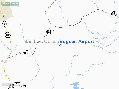
Bogdan Airport
Address:
San Luis Obispo County, CA
Tel:
805-438-4444
Images
and information placed above are from
http://www.airport-data.com/airport/5CL1/
We
thank them for the data!
| General
Info |
| Country |
United
States |
| State |
CALIFORNIA
|
| FAA ID |
5CL1
|
| Latitude |
35-24-17.000N
|
| Longitude |
120-31-30.000W
|
| Elevation |
1380 feet
|
| Near City |
SANTA
MARGARITA |
We don't guarantee the information is fresh and accurate. The data may
be wrong or outdated.
For more up-to-date information please refer to other sources.
|
|


