 |
|
|
|
|
|
Location
& QuickFacts
|
FAA
Information Effective: |
2006-06-08 |
|
Airport
Identifier: |
8CL9 |
|
Longitude/Latitude: |
120-01-48.5600W/36-42-44.8040N
-120.030156/36.712446 (Estimated) |
|
Elevation: |
222 ft / 67.67 m (Estimated) |
|
Land: |
0 acres |
|
From
nearest city: |
2 nautical miles SE of Kerman, CA |
|
Location: |
Fresno County, CA |
|
Magnetic Variation: |
15E (1985) |
Owner
& Manager
|
Ownership: |
Privately owned |
|
Owner: |
Russell Bland |
|
Address: |
1530 S Howard Avenue
Kerman, CA 93630 |
|
Phone number: |
209-846-8256 |
|
Manager: |
Gerald Bland |
|
Address: |
13888 W. Belmont
Kerman, CA 93630 |
|
Phone number: |
846-9757 |
Airport
Operations and Facilities
|
Airport
Use: |
Private |
|
Wind
indicator: |
Yes |
|
Segmented
Circle: |
No |
|
Control
Tower: |
No |
|
Attendance
Schedule: |
UNATNDD |
|
Landing
fee charge: |
No |
|
Sectional
chart: |
San Francisco |
|
Region: |
AWP - Western-Pacific |
|
Traffic Pattern Alt: |
800 ft |
|
Boundary ARTCC: |
ZOA - Oakland |
|
Tie-in FSS: |
RIU - Rancho Murieta |
|
FSS on Airport: |
No |
|
FSS Phone: |
916-354-0161 |
|
FSS Toll Free: |
1-800-WX-BRIEF |
Airport
Services
|
Airframe
Repair: |
NONE |
|
Power
Plant Repair: |
NONE |
|
Bottled
Oxygen: |
NONE |
|
Bulk
Oxygen: |
NONE |
|
Runway Information
Runway 12/30
|
Dimension: |
1800 x 60 ft / 548.6 x 18.3 m |
|
Surface: |
TRTD-DIRT, Good Condition |
|
|
Runway 12 |
Runway 30 |
|
Traffic
Pattern: |
Left |
Left |
|
Markings: |
Nonstandard, |
Nonstandard, |
|
Runway
End Identifier: |
No |
No |
|
Centerline
Lights: |
No |
No |
|
Touchdown
Lights: |
No |
No |
|
Radio Navigation
Aids
|
ID |
Type |
Name |
Ch |
Freq |
Var |
Dist |
|
FCH |
NDB |
Chandler |
|
344.00 |
15E |
9.5 nm |
|
CUK |
NDB |
Academy |
|
266.00 |
14E |
19.0 nm |
|
COR |
NDB |
Salyer Farms |
|
205.00 |
16E |
45.6 nm |
|
NLC |
TACAN |
Lemoore |
080X |
|
16E |
22.4 nm |
|
ROM |
VOR |
Priest |
|
110.00 |
16E |
46.1 nm |
|
VIS |
VOR/DME |
Visalia |
031X |
109.40 |
16E |
33.6 nm |
|
HYP |
VOR/DME |
El Nido |
089X |
114.20 |
15E |
35.3 nm |
|
CZQ |
VORTAC |
Clovis |
076X |
112.90 |
15E |
14.6 nm |
|
FRA |
VORTAC |
Friant |
103X |
115.60 |
17E |
31.5 nm |
|
PXN |
VORTAC |
Panoche |
073X |
112.60 |
16E |
36.1 nm |
Remarks
- PLINE
100' FROM RWY THR 50' SW OF CNTRLINE.
- PRIOR
PERMISON REQUIRED FOR ALL ACFT BEFORE LANDING, CALL 209-846-9757.
- ESTABD
PRIOR TO 15 MAY 1959.
Based Aircraft
|
Aircraft
based on field: |
2 |
|
Single
Engine Airplanes: |
2 |
Operational Statistics
|
Aircraft
Operations: |
194/Week |
|
General
Aviation Local: |
99.5% |
|
General
Aviation Itinerant: |
0.5% |
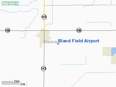
Bland Field Airport
Address:
Fresno County, CA
Tel:
209-846-8256
Images
and information placed above are from
http://www.airport-data.com/airport/8CL9/
We
thank them for the data!
| General
Info |
| Country |
United
States |
| State |
CALIFORNIA
|
| FAA ID |
8CL9
|
| Latitude |
36-42-44.804N
|
| Longitude |
120-01-48.560W
|
| Elevation |
222 feet
|
| Near City |
KERMAN
|
We don't guarantee the information is fresh and accurate. The data may
be wrong or outdated.
For more up-to-date information please refer to other sources.
|
|


