 |
|
Bakersfield Municipal Airport |
| Bakersfield Municipal Airport |
 |
| IATA: none – ICAO: none – FAA LID: L45 |
| Summary |
| Airport type |
Public |
| Owner |
City of Bakersfield |
| Serves |
Bakersfield, California |
| Elevation AMSL |
378 ft / 115 m |
| Coordinates |
35°19′30″N 118°59′46″W / 35.325°N 118.99611°W / 35.325; -118.99611 |
| Runways |
| Direction |
Length |
Surface |
| ft |
m |
| 16/34 |
4,000 |
1,219 |
Asphalt |
| Statistics (2009) |
| Aircraft operations |
25,000 |
| Based aircraft |
82 |
| Source: Federal Aviation Administration |
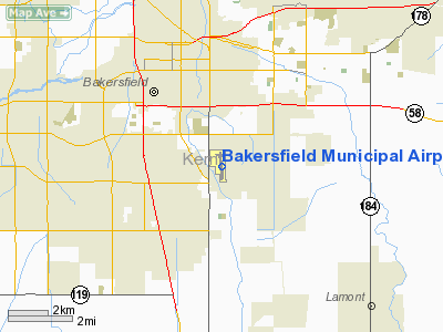
Bakersfield Municipal Airport (FAA LID: L45) is a city-owned public-use airport located three nautical miles (6 km) south of the central business district of Bakersfield, a city in Kern County, California, United States. The airport is mostly used for general aviation. History
During World War II the airfield was used by the United States Army Air Force Air Transport Command as a Sub-base of Hammer Field.
Facilities and aircraft
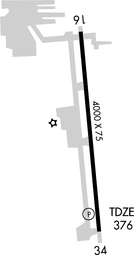
Bakersfield Municipal Airport covers an area of 253 acres (102 ha) at an elevation of 378 feet (115 m) above mean sea level. It has one runway designated 16/34 with an asphalt surface measuring 4,000 by 75 feet (1,219 x 23 m).
For the 12-month period ending April 13, 2009, the airport had 25,000 general aviation aircraft operations, an average of 68 per day. At that time there were 82 aircraft based at this airport: 90% single-engine and 10% multi-engine.
The above content comes from Wikipedia and is published under free licenses – click here to read more.
Location
& QuickFacts
|
FAA
Information Effective: |
2006-06-08 |
|
Airport
Identifier: |
L45 |
|
Longitude/Latitude: |
118-59-45.0000W/35-19-29.4000N
-118.995833/35.324833 (Estimated) |
|
Elevation: |
376 ft / 114.60 m (Estimated) |
|
Land: |
253 acres |
|
From
nearest city: |
3 nautical miles S of Bakersfield, CA |
|
Location: |
Kern County, CA |
|
Magnetic Variation: |
14E (1990) |
Owner
& Manager
|
Ownership: |
Publicly owned |
|
Owner: |
City Of Bakersfield |
|
Address: |
1501 Truxtun Ave
Bakersfield, CA 93307 |
|
Phone
number: |
661-326-3781 |
|
Manager: |
Brad B. Underwood
ON AIRPORT CONTACT: MR. JOE LOZANO, (661)326-3781 |
|
Address: |
4101 Truxtun Avenue
Bakersfield, CA 93309 |
|
Phone number: |
661-326-3781 |
Airport
Operations and Facilities
|
Airport
Use: |
Open to public |
|
Wind
indicator: |
Yes |
|
Segmented
Circle: |
Yes |
|
Control
Tower: |
No |
|
Attendance
Schedule: |
ALL/ALL/0700-1700 |
|
Lighting
Schedule: |
DUSK-DAWN |
|
Beacon
Color: |
Clear-Green (lighted land airport) |
|
Landing
fee charge: |
No |
|
Sectional
chart: |
Los Angeles |
|
Region: |
AWP - Western-Pacific |
|
Traffic
Pattern Alt: |
800 ft |
|
Boundary
ARTCC: |
ZLA - Los Angeles |
|
Tie-in
FSS: |
RIU - Rancho Murieta |
|
FSS
on Airport: |
No |
|
FSS
Phone: |
916-354-0161 |
|
FSS
Toll Free: |
1-800-WX-BRIEF |
|
NOTAMs
Facility: |
RIU (NOTAM-d service avaliable) |
|
Federal Agreements: |
NGY |
Airport
Communications
|
CTAF: |
122.800 |
|
Unicom: |
122.800 |
Airport
Services
|
Fuel
available: |
100LL |
|
Airframe
Repair: |
MAJOR |
|
Power
Plant Repair: |
MAJOR |
|
Runway Information
Runway 16/34
|
Dimension: |
4000
x 75 ft / 1219.2 x 22.9 m
150 FT PAVED STOPWAY AT EACH END OF RWY. |
|
Surface: |
ASPH, Good Condition |
|
Weight
Limit: |
Single wheel: 20000 lbs. |
|
Edge
Lights: |
Medium |
|
|
Runway 16 |
Runway 34 |
|
Longitude: |
118-59-47.9500W |
118-59-43.3700W |
|
Latitude: |
35-19-49.2300N |
35-19-09.8600N |
|
Elevation: |
376.00 ft |
370.00 ft |
|
Alignment: |
127 |
127 |
|
Traffic
Pattern: |
Right |
Left |
|
Markings: |
Non-precision instrument, Good Condition |
Non-precision instrument, Good Condition |
|
Crossing
Height: |
0.00 ft |
54.00 ft |
|
VASI: |
|
2-light PAPI on left side |
|
Visual
Glide Angle: |
0.00� |
4.00� |
|
Runway
End Identifier: |
|
Yes |
|
Obstruction: |
15 ft road, 650.0 ft from runway, 170 ft left
of centerline, 30:1 slope to clear |
103 ft pline, 2500.0 ft from runway, 22:1 slope
to clear |
|
Radio Navigation
Aids
|
ID |
Type |
Name |
Ch |
Freq |
Var |
Dist |
|
TTE |
VOR/DME |
Tule |
029X |
109.20 |
16E |
35.4 nm |
|
EHF |
VORTAC |
Shafter |
101X |
115.40 |
14E |
10.8 nm |
|
GMN |
VORTAC |
Gorman |
108X |
116.10 |
16E |
32.0 nm |
|
LHS |
VORTAC |
Lake Hughes |
021X |
108.40 |
15E |
43.7 nm |
|
FLW |
VORTAC |
Fellows |
122X |
117.50 |
16E |
44.9 nm |
|
BFL |
VOT |
Bakersfield |
|
111.20 |
|
6.5 nm |
Remarks
- +100
FT POLE LINE 1/2 MILE SOUTH OF ARPT.
- ESTABD
PRIOR TO 1959.
Based Aircraft
|
Aircraft
based on field: |
98 |
|
Single
Engine Airplanes: |
96 |
|
Multi
Engine Airplanes: |
2 |
Operational Statistics
|
Aircraft
Operations: |
69/Day |
|
General
Aviation Local: |
40.0% |
|
General
Aviation Itinerant: |
60.0% |
Bakersfield Municipal Airport
Address:
Kern County, CA
Tel:
661-326-3781
Images
and information placed above are from
http://www.airport-data.com/airport/L45/
We
thank them for the data!
| General
Info |
| Country |
United
States |
| State |
CALIFORNIA
|
| FAA ID |
L45
|
| Latitude |
35-19-29.400N
|
| Longitude |
118-59-45.000W
|
| Elevation |
376 feet
|
| Near City |
BAKERSFIELD
|
We don't guarantee the information is fresh and accurate. The data may
be wrong or outdated.
For more up-to-date information please refer to other sources.
|
|


