 |
|
|
|
|
|
Location
& QuickFacts
|
FAA
Information Effective: |
2006-06-08 |
|
Airport
Identifier: |
2CA0 |
|
Longitude/Latitude: |
118-50-03.3550W/36-29-44.8050N
-118.834265/36.495779 (Estimated) |
|
Elevation: |
1820 ft / 554.74 m (Estimated) |
|
Land: |
0 acres |
|
From
nearest city: |
4 nautical miles NE of Three Rivers, CA |
|
Location: |
Tulare County, CA |
|
Magnetic Variation: |
15E (1985) |
Owner
& Manager
|
Ownership: |
Privately owned |
|
Owner: |
Sequoia-kings Canyon Park |
|
Address: |
Three Rivers, CA 93271 |
|
Phone
number: |
209-565-3341 |
|
Manager: |
Superintendent |
|
Address: |
Sequoia-kings Natl Parks
Three Rivers, CA 93271 |
|
Phone number: |
209-565-3341 |
Airport
Operations and Facilities
|
Airport
Use: |
Private |
|
Wind
indicator: |
Yes |
|
Segmented
Circle: |
No |
|
Control
Tower: |
No |
|
Attendance
Schedule: |
MAY-OCT/ALL/0800-1800 |
|
Landing
fee charge: |
No |
|
Sectional
chart: |
San Francisco |
|
Region: |
AWP - Western-Pacific |
|
Boundary
ARTCC: |
ZOA - Oakland |
|
Tie-in
FSS: |
RIU - Rancho Murieta |
|
FSS on Airport: |
No |
|
FSS Phone: |
916-354-0161 |
|
FSS Toll Free: |
1-800-WX-BRIEF |
Airport
Services
|
Airframe
Repair: |
NONE |
|
Power
Plant Repair: |
NONE |
|
Bottled
Oxygen: |
NONE |
|
Bulk
Oxygen: |
NONE |
|
Runway Information
Helipad H1
|
Dimension: |
230 x 100 ft / 70.1 x 30.5 m |
|
Surface: |
ASPH-TURF, |
|
|
Runway H1 |
Runway |
|
Traffic
Pattern: |
Left |
Left |
|
Runway
End Identifier: |
No |
|
|
Centerline
Lights: |
No |
|
|
Touchdown
Lights: |
No |
|
|
Radio Navigation
Aids
|
ID |
Type |
Name |
Ch |
Freq |
Var |
Dist |
|
CUK |
NDB |
Academy |
|
266.00 |
14E |
41.2 nm |
|
COR |
NDB |
Salyer Farms |
|
205.00 |
16E |
42.7 nm |
|
VIS |
VOR/DME |
Visalia |
031X |
109.40 |
16E |
32.3 nm |
|
TTE |
VOR/DME |
Tule |
029X |
109.20 |
16E |
36.2 nm |
Based Aircraft
|
Aircraft
based on field: |
1 |
|
Helicopters: |
1 |
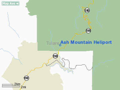
Ash Mountain Heliport
Address:
Tulare County, CA
Tel:
209-565-3341
Images
and information placed above are from
http://www.airport-data.com/airport/2CA0/
We
thank them for the data!
| General
Info |
| Country |
United
States |
| State |
CALIFORNIA
|
| FAA ID |
2CA0
|
| Latitude |
36-29-44.805N
|
| Longitude |
118-50-03.355W
|
| Elevation |
1820 feet
|
| Near City |
THREE
RIVERS |
We don't guarantee the information is fresh and accurate. The data may
be wrong or outdated.
For more up-to-date information please refer to other sources.
|
|


