 |
|
|
|
Location
& QuickFacts
|
FAA
Information Effective: |
2006-06-08 |
|
Airport
Identifier: |
52CL |
|
Longitude/Latitude: |
117-27-38.1750W/34-32-14.9750N
-117.460604/34.537493 (Estimated) |
|
Elevation: |
3075 ft / 937.26 m (Estimated) |
|
Land: |
350 acres |
|
From
nearest city: |
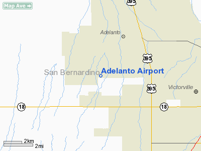
4 nautical miles SW of Adelanto, CA |
|
Location: |
San Bernardino County, CA |
|
Magnetic
Variation: |
14E (1985) |
Owner
& Manager
|
Ownership: |
Privately owned |
|
Owner: |
Adelanto Airport
PROPERTY OWNERS ASSOCIATION |
|
Address: |
P O Box 207
Adelanto, CA 92301 |
|
Manager: |
Phil Brown |
|
Address: |
9175 Poppy Road
Adelanto, CA 92301 |
|
Phone number: |
619-246-8532 |
Airport
Operations and Facilities
|
Airport Use: |
Private |
|
Wind indicator: |
Yes |
|
Segmented Circle: |
Yes |
|
Control Tower: |
No |
|
Attendance Schedule: |
IREG |
|
Landing fee charge: |
No |
|
Sectional chart: |
Los Angeles |
|
Region: |
AWP - Western-Pacific |
|
Boundary ARTCC: |
ZLA - Los Angeles |
|
Tie-in FSS: |
RAL - Riverside |
|
FSS on Airport: |
No |
|
FSS Phone: |
951-351-3020 |
|
FSS Toll Free: |
1-800-WX-BRIEF |
Airport
Services
|
Airframe
Repair: |
NONE |
|
Power
Plant Repair: |
NONE |
|
Runway
Information
Runway E/W
|
Dimension: |
5100 x 100 ft / 1554.5 x 30.5 m |
|
Surface: |
DIRT, |
|
|
Runway E |
Runway W |
|
Traffic
Pattern: |
Right |
Left |
|
Displaced
threshold: |
300.00 ft |
300.00 ft |
|
Obstruction: |
3 ft fence, 20.0 ft from runway |
3 ft fence, 20.0 ft from runway |
|
Runway N/S
|
Dimension: |
3930 x 100 ft / 1197.9 x 30.5 m |
|
Surface: |
DIRT, |
|
|
Runway N |
Runway S |
|
Traffic
Pattern: |
Left |
Right |
|
Displaced
threshold: |
300.00 ft |
300.00 ft |
|
Obstruction: |
150 ft pline, 2600.0 ft from runway |
200 ft pline, 5200.0 ft from runway |
|
Radio Navigation
Aids
|
ID |
Type |
Name |
Ch |
Freq |
Var |
Dist |
|
SB |
NDB |
Petis |
|
397.00 |
14E |
29.3 nm |
|
EMT |
NDB |
El Monte |
|
359.00 |
15E |
39.1 nm |
|
GWF |
NDB |
Gen William J Fox |
|
282.00 |
15E |
39.3 nm |
|
RIV |
TACAN |
March |
077X |
|
14E |
39.0 nm |
|
RAL |
VOR |
Riverside |
|
112.40 |
15E |
35.2 nm |
|
HDF |
VOR |
Homeland |
|
113.40 |
14E |
47.8 nm |
|
VCV |
VOR/DME |
Victorville |
031X |
109.40 |
14E |
4.9 nm |
|
EDW |
VORTAC |
Edwards |
111X |
116.40 |
15E |
29.9 nm |
|
PMD |
VORTAC |
Palmdale |
092X |
114.50 |
15E |
30.4 nm |
|
POM |
VORTAC |
Pomona |
041X |
110.40 |
15E |
32.0 nm |
|
PDZ |
VORTAC |
Paradise |
059X |
112.20 |
15E |
37.4 nm |
Remarks
- CLEARALL
APCHS WITH GEORGE AFB ON UNICOM 124.05 FOR CONFLICTING TRAFFIC.
- RY
NORTH & RY SOUTH FENCE - MARKED - 3 FT HGT 20 FT FM RY END.
- (02)
CHECK WITH TOWER AT GEORGE AFB FOR CONFLICTING TRAFFIC
- PVT
USE & RDO COMM WITH GEORGE AFB TWR-126.2
Based Aircraft
|
Aircraft
based on field: |
21 |
|
Single
Engine Airplanes: |
15 |
|
Helicopters: |
3 |
|
Gliders: |
2 |
|
Ultralights: |
1 |
Adelanto Airport
Address: San Bernardino County, CA
Tel:
619-246-8532
Images
and information placed above are from
http://www.airport-data.com/airport/52CL/
We
thank them for the data!
| General
Info |
| Country |
United
States |
| State |
CALIFORNIA
|
| FAA ID |
52CL
|
| Latitude |
34-32-14.975N
|
| Longitude |
117-27-38.175W
|
| Elevation |
3075 feet
|
| Near City |
ADELANTO
|
We don't guarantee the information is fresh and accurate. The data may be wrong or outdated.
For more up-to-date information please refer to other sources.
|
|


