 |
|
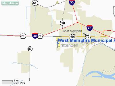
West Memphis Municipal Airport |
Coordinates: 35°08′06″N 090°14′04″W / 35.135°N 90.23444°W / 35.135; -90.23444
| West Memphis Municipal Airport |
| IATA: AWM – ICAO: KAWM – FAA LID: AWM |
| Summary |
| Airport type |
Public |
| Owner |
City of West Memphis |
| Serves |
West Memphis, Arkansas |
| Elevation AMSL |
212 ft / 65 m |
| Runways |
| Direction |
Length |
Surface |
| ft |
m |
| 17/35 |
6,003 |
1,830 |
Concrete |
| Statistics (2006) |
| Aircraft operations |
75,000 |
| Based aircraft |
124 |
| Source: Federal Aviation Administration |
West Memphis Municipal Airport (IATA: AWM, ICAO: KAWM, FAA LID: AWM) is a city-owned public-use airport located three miles (5 km) west of the central business district of West Memphis, in Crittenden County, Arkansas, United States.
According to the FAA's National Plan of Integrated Airport Systems for 2007-2011, West Memphis Municipal Airport is categorized as a reliever airport.
Facilities and aircraft
West Memphis Municipal Airport covers an area of 457 acres (185 ha) which contains one concrete paved runway (17/35) measuring 6,003 x 100 ft (1,830 x 30 m). For the 12-month period ending August 31, 2006, the airport had 75,000 aircraft operations, an average of 205 per day: 99.7% general aviation and 0.3% military. There are 124 aircraft based at this airport: 82% single-engine, 17% multi-engine and 1% helicopter.
The above content comes from Wikipedia and is published under free licenses – click here to read more.
Location
& QuickFacts
| FAA
Information Effective: |
2006-02-16 |
| Airport
Identifier: |
AWM |
| Longitude/Latitude: |
090-14-04.0070W/35-08-06.2110N
-90.234446/35.135059 (Estimated) |
| Elevation: |
212
ft / 64.62 m (Surveyed) |
| Land: |
457 acres |
| From
nearest city: |
3
nautical miles W of West Memphis, AR |
| Location: |
Crittenden County, AR |
| Magnetic
Variation: |
01E
(1995) |
Owner &
Manager
| Ownership: |
Publicly owned |
| Owner: |
City
Of West Memphis |
| Address: |
Po
Box 1728
West Memphis, AR 72303 |
| Phone
number: |
870-732-7500 |
| Manager: |
Lynda Avery |
| Address: |
737
South Airport Rd
West Memphis, AR 72301 |
| Phone
number: |
870-735-4656 |
Airport
Operations and Facilities
| Airport
Use: |
Open to public |
| Wind
indicator: |
Yes |
| Segmented
Circle: |
Yes |
| Control
Tower: |
Yes |
| Attendance
Schedule: |
ALL/ALL/0700-1900
FOR SVC AFT HRS CALL 870-735-4656; FEE CHARGED. |
| Lighting
Schedule: |
DUSK-DAWN
MIRL RY 17/35 PRESET LOW INTST; TO INCR INTST & ACTVT MALSR
RY 17; PAPI RY 35; REIL RYS 17 & 35 - CTAF. |
| Beacon
Color: |
Clear-Green
(lighted land airport) |
| Landing
fee charge: |
No |
| Sectional
chart: |
Memphis |
| Region: |
ASW
- Southwest |
| Boundary
ARTCC: |
ZME - Memphis |
| Tie-in
FSS: |
JBR
- Jonesboro |
| FSS
on Airport: |
No |
| FSS
Phone: |
870-935-3471 |
| FSS
Toll Free: |
1-800-WX-BRIEF |
| NOTAMs
Facility: |
AWM
(NOTAM-d service avaliable) |
| Federal
Agreements: |
NGY |
Airport
Communications
| CTAF: |
123.050 |
| Unicom: |
123.050
|
Airport
Services
| Fuel
available: |
100LLA
24 HR SELF SERVICE FUEL AVBL WITH CREDIT CARD. |
| Airframe
Repair: |
MAJOR |
| Power
Plant Repair: |
MAJOR |
| Bottled
Oxygen: |
NONE |
| Bulk
Oxygen: |
NONE |
Runway
Information
Runway
17/35
| Dimension: |
6003 x
100 ft / 1829.7 x 30.5 m |
| Surface: |
CONC, Fair Condition |
| Weight Limit: |
Single wheel: 30000
lbs.
Dual wheel: 45000 lbs. |
| Edge
Lights: |
Medium |
| |
Runway 17 |
Runway 35 |
| Longitude: |
090-14-03.6570W |
090-14-04.3580W |
| Latitude: |
35-08-35.8960N |
35-07-36.5260N |
| Elevation: |
212.00 ft |
212.00 ft |
| Alignment: |
127 |
1 |
| ILS
Type: |
ILS/DME
|
|
| Traffic Pattern: |
Left |
Left |
| Markings: |
Precision
instrument, Poor Condition
MARKINGS BADLEY FADED. |
Precision
instrument, Poor Condition
MARKINGS BADLEY FADED. |
| Crossing
Height: |
0.00 ft |
40.00 ft |
| VASI: |
|
4-light
PAPI on left side |
| Visual Glide
Angle: |
0.00° |
3.00° |
| Approach
lights: |
MALSR |
|
| Runway End
Identifier: |
Yes |
Yes |
|
Radio Navigation
Aids
|
ID |
Type |
Name |
Ch |
Freq |
Var |
Dist |
| AWM |
NDB |
West Memphis |
|
362.00 |
01E |
0.3 nm |
| ME |
NDB |
Elvis |
|
287.00 |
01E |
9.1 nm |
| SPQ |
NDB |
Spain |
|
414.00 |
04E |
9.8 nm |
| MIG |
NDB |
Millington |
|
232.00 |
04E |
17.1 nm |
| OLV |
NDB |
Olive Branch |
|
275.00 |
01E |
23.8 nm |
| FCY |
NDB |
Forrest City |
|
332.00 |
01E |
29.0 nm |
| BPW |
NDB |
Osceola |
|
239.00 |
02E |
35.2 nm |
| HEE |
NDB |
Thompson-robbins |
|
251.00 |
01E |
40.3 nm |
| FYE |
NDB |
Somerville |
|
255.00 |
00E |
41.6 nm |
| COO |
NDB |
Covington |
|
326.00 |
02E |
41.9 nm |
| MXA |
NDB |
Manila |
|
282.00 |
01E |
45.6 nm |
| BKZ |
NDB |
Brinkley |
|
242.00 |
02E |
48.9 nm |
| GQE |
VOR/DME |
Gilmore |
077X |
113.00 |
04E |
17.5 nm |
| UJM |
VOR/DME |
Marvell |
033X |
109.60 |
01E |
40.0 nm |
| JBR |
VOR/DME |
Jonesboro |
023X |
108.60 |
02E |
47.7 nm |
| MEM |
VORTAC |
Memphis |
122X |
117.50 |
01E |
14.3 nm |
| HLI |
VORTAC |
Holly Springs |
071X |
112.40 |
03E |
42.5 nm |
| MEM |
VOT |
Memphis Metropolitn |
|
111.00 |
|
13.6 nm |
West Memphis Municipal
Airport
Address: Crittenden
County, AR
Tel: 870-735-4656
Images and information placed
above are from
http://www.airport-data.com/airport/AWM/
We
thank them for the data!
|
General Info |
| Country |
United
States |
| State |
ARKANSAS
|
| FAA
ID |
AWM
|
| Latitude |
35-08-06.211N
|
| Longitude |
090-14-04.007W
|
| Elevation |
212
feet |
| Near
City |
WEST
MEMPHIS |
We don't guarantee the information is fresh and accurate. The data may be wrong or outdated.
For more up-to-date information please refer to other sources.
|
|


