|
 |
|
||||
|
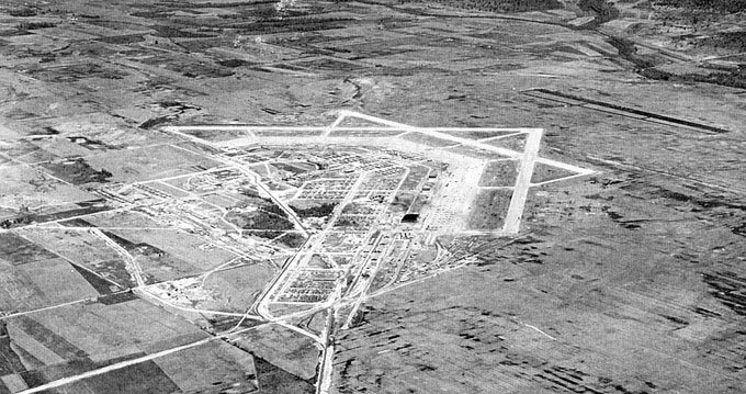
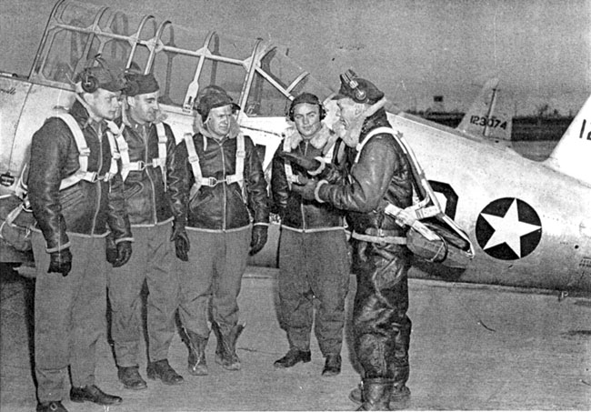
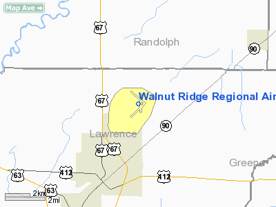
Walnut Ridge Regional Airport (IATA: ARG, ICAO: KARG, FAA LID: ARG) is a city-owned public-use airport located four nautical miles (7 km) northeast of the central business district of Walnut Ridge, a city in Lawrence County, Arkansas, United States. According to the FAA's National Plan of Integrated Airport Systems for 2009–2013, it is categorized as a general aviation facility. HistoryArmy AirfieldThe airfield was built in 1942/43 and opened in October 1943 as Walnut Ridge Army Airfield and was used by the United States Army Air Forces as a training base during World War II. Walnut Ridge was commanded by the 324th Army Air Force Base Unit, being assiged to the AAF Southeast Training Center. Designed for 5,114 military personnel, and 976 civilians, Walnut Ridge AAF had three (3) 5,000-foot runways, a huge apron covering over 63 acres (250,000 m), 4 large hangars, base engineering building, and fully equipped 203 bed hospital. It also included, 131,151 sq ft (12,184.3 m). of office space, 119,613 sq ft (11,112.4 m). of enclosed storage space, 49,324 sq ft (4,582.3 m). shop space, a water plant and sewer plant designed to serve 5,000 troops, and a 10,000-man laundry, 2 theaters, a swimming pool, gymnasium, WAC housing, eight mess halls, dozens of enlisted-men's barracks, parachute loft, gas chamber, 260 tile-block apartments, motor pool, control tower, officers' club, link-trainer buildings, fire station, several warehouses, crash station, and 9.64 miles (15.51 km) of streets. Construction and land cost was almost ten and one-half million dollars. The Air Field was activated on August 15, 1942, with the arrival of the initial contingent of key military personnel. Ten days later, 100 troops arrived, but there was no housing available on the air field, so these troops were transported to and from the CCC camp, located at five-mile (8 km) springs, north of Pocahontas for the first 30 days. Even though the airfield was planned and designed as an Army Airfield, for some time it appeared it would instead become an Advanced Glider School. As late as September 1942, preparations were being made for gliders, including requests for instructional materials, gliders and tow planes. Meanwhile the first 3 classes of Aviation Cadets programmed for Walnut Ridge were sent to Blytheville, which was being built as an Advanced Twin Engine School. Blytheville was scarcely any better prepared than Walnut Ridge. Circus tents were utilized for operations headquarters and classrooms. The runways were not ready, so flying was done from oil-coated dirt strips. Finally, near the end of September the Southeast Training Command at Maxwell Field clarified the situation concerning the Air Field's mission by announcing 102 Aviation Cadets and 3 Student Officers from Decatur, Alabama, and 20 Aviation Cadets from Camden, Arkansas, would be sent to Walnut Ridge for Basic Flight Training. For reasons unknown, the Advanced Glider School was established at Stuttgart, which was being built as an Advanced Twin-Engine School. During the eleven month period from November 1, 1942, thru September 30, 1943, the training hours flown at Walnut Ridge were 160,648. The average for all Basic Flying Schools in the Southeast Training Command was 129,474. Walnut Ridge had .49 accidents per 1000 hours versus .57 accidents per 1000 hours average for all schools; however, the fatal accident rate at Walnut Ridge was higher, .087 per 1000 hours versus a .052 average. The hours flown at Walnut Ridge through June 30, 1944, totaled 414,429. Walnut Ridge was also a major maintenance facility, servicing C-47s, P-40s, P-51s, B-17s and B-29s. Marine Corps Air FacilityOn September 1, 1944, Walnut Ridge AAF was transferred to the Department of the Navy and was known as the Marine Corps Air Facility Walnut Ridge. The Marine Corps trained for only a brief time, using SBD-5’s and FG-1D Corsair’s. VMF-513 transferred to MCAF Walnut Ridge on September 14, 1944, and then moved to MCAS Mojave, California, on December 4, 1944. MCAF Walnut Ridge was decommissioned March 15, 1945. RFC Walnut RidgeIn 1945 the Reconstruction Finance Corporation (RFC) established five large storage, sales and scrapping centers for Army Air Forces aircraft. These were located at: Albuquerque, NM; Altus, OK; Kingman, AZ; Ontario, CA; and Walnut Ridge, AR. A sixth facility for storing, selling and scrapping Navy and Marine aircraft was located at Clinton, OK. It is estimated that approximately 10,000 warbirds were flown to Walnut Ridge in 1945 and 1946 for storage and sale. Some sources report the number to be over 11,000. It is reported that at least 67 of the 118 B-32 Heavy Bombers built were flown to Walnut Ridge, many straight from the assembly line. Of the remaining B-32’s, at least 37, perhaps more, were flown to Kingman. Four thousand, eight hundred and seventy-one (4,871) of the aircraft stored at Walnut Ridge, primarily fighters and bombers, were sold to Texas Railway Equipment Company in September 1946, to be scrapped. The bid price was $1,838,798.19. On the southwest corner of the ramp, two giant smelters were constructed to melt the scrap aluminum, which was formed into huge ingots for shipping. The aircraft at Altus were put up for scrap bid in 1947, and sold on May 12, 1947, to Esperado Mining Company of Walnut Ridge. (Probably owned in whole or part by Texas Railway Equipment Company, the company that scrapped the warbirds at Walnut Ridge.) By late 1947 scrapping had been completed at Clinton and the big five scrapping facilities, except Altus, which finished by mid 1948. The tens of thousands of proud warbirds that had survived the enemy fighter planes and fierce anti-aircraft fire could not escape the smelters at Albuquerque, Altus, Kingman, Ontario, Walnut Ridge and Clinton. At Walnut Ridge, the two smelters used to turn the proud Warbirds into aluminum ingots were torn down about 1951. In 1952 the City of Walnut Ridge used the firebricks from the smelters to construct an administration/terminal building on the site of the WWII Base Operations building. Civil useIn the early 1960s, Walnut Ridge was determined to be excess by the military and turned over to the local government for civil use.
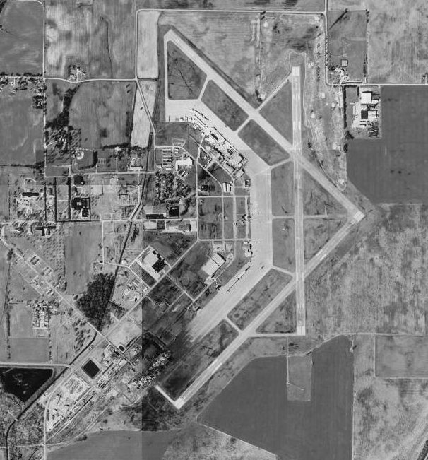
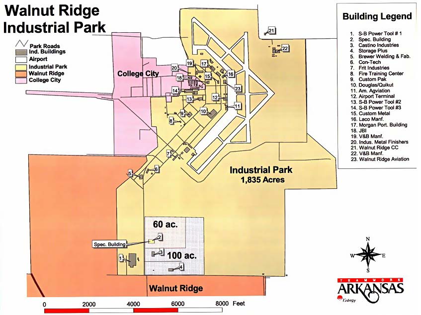
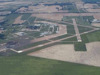
Facilities and aircraftWalnut Ridge Regional Airport covers an area of 1,800 acres (728 ha) at an elevation of 279 feet (85 m) above mean sea level. It has three runways: 4/22 is 6,001 by 150 feet (1,829 x 46 m) with an asphalt surface; 13/31 is 5,003 by 150 feet (1,525 x 46 m) with a concrete surface; 18/36 is 5,001 by 150 feet (1,524 x 46 m) with a concrete surface. For the 12-month period ending July 31, 2008, the airport had 94,000 aircraft operations, an average of 257 per day: 97% general aviation, 2% military, and1% air taxi. At that time there were 55 aircraft based at this airport: 62% single-engine, 9% multi-engine, 27% jet and 2% helicopter. The above content comes from Wikipedia and is published under free licenses – click here to read more.
Location & QuickFacts
Owner & Manager
Airport Operations and Facilities
Airport Communications
Airport Services
Runway InformationRunway 04/22
Runway 13/31
Runway 18/36
Radio Navigation Aids
Remarks
Walnut Ridge Regional Airport
Telephone: (870) 886-5432 E-mail: wraaf@bscn.com URL: http://www.walnutridge-aaf.com/ Images
and information placed above are from
http://www.walnutridge-aaf.com/
We don't guarantee the information is fresh and accurate. The data may be wrong or outdated. For more up-to-date information please refer to other sources. |
||||||||||||||||||||||||||||||||||||||||||||||||||||||||||||||||||||||||||||||||||||||||||||||||||||||||||||||||||||||||||||||||||||||||||||||||||||||||||||||||||||||||||||||||||||||||||||||||||||||||||||||||||||||||||||||||||||||||||||||||||||||||||||||||||||||||||||||||||||||||||||||||||||||||||||||||||||||||||||||||||||||||||||||||||||||||||||||||||||||||||||||||||||||||||||||||||||||||||||||||||||||||

 |
|
Copyright 2004-2026 © by Airports-Worldwide.com, Vyshenskoho st. 36, Lviv 79010, Ukraine Legal Disclaimer |