 |
|
Location
& QuickFacts
| FAA
Information Effective: |
2006-02-16 |
| Airport
Identifier: |
1AR1 |
| Longitude/Latitude: |
091-52-21.5900W/34-31-37.8400N
-91.872664/34.527178 (Estimated) |
| Elevation: |
215
ft / 65.53 m (Estimated) |
| Land: |
0 acres |
| From
nearest city: |
1
nautical miles S of Coy, AR |
| Location: |
Lonoke County, AR |
| Magnetic
Variation: |
03E
(1995) |
Owner &
Manager
| Ownership: |
Privately owned |
| Owner: |
Charles
Capps |
| Address: |
17555 Hwy 31 S
England, AR 72046 |
| Phone
number: |
501-275-3466 |
| Manager: |
Charles Capps |
| Address: |
17555
Hwy 31 S
England, AR 72046 |
| Phone
number: |
501-275-3466 |
Airport
Operations and Facilities
| Airport
Use: |
Private |
| Segmented
Circle: |
No |
| Control
Tower: |
No |
| Attendance
Schedule: |
UNATNDD |
| Lighting
Schedule: |
DUSK-DAWN |
| Sectional
chart: |
Memphis |
| Region: |
ASW - Southwest |
| Boundary
ARTCC: |
ZME
- Memphis |
| Tie-in
FSS: |
JBR - Jonesboro |
| FSS
on Airport: |
No |
| FSS
Phone: |
870-935-3471 |
| FSS
Toll Free: |
1-800-WX-BRIEF |
Runway
Information
Runway
18/36
| Dimension: |
2500 x
60 ft / 762.0 x 18.3 m |
| Surface: |
TURF,
|
| Edge Lights: |
Low |
| |
Runway 18 |
Runway 36 |
| Traffic
Pattern: |
Left |
Left |
|
Radio Navigation
Aids
|
ID |
Type |
Name |
Ch |
Freq |
Var |
Dist |
| SGT |
NDB |
Stuttgart |
|
269.00 |
02E |
16.2 nm |
| TYV |
NDB |
Toneyville |
|
290.00 |
04E |
26.6 nm |
| BKZ |
NDB |
Brinkley |
|
242.00 |
02E |
40.4 nm |
| SRC |
NDB |
Searcy |
|
323.00 |
02E |
41.7 nm |
| CWS |
NDB |
Conway |
|
302.00 |
05E |
43.2 nm |
| MVQ |
NDB |
Malvern |
|
215.00 |
04E |
45.6 nm |
| LRF |
TACAN |
Jacksonville |
029X |
|
04E |
27.4 nm |
| PBF |
VOR/DME |
Pine Bluff |
107X |
116.00 |
04E |
17.1 nm |
| LIT |
VORTAC |
Little Rock |
086X |
113.90 |
05E |
17.7 nm |
Remarks
- WATER-TANK NW.
- NUMEROUS AGRICULTURAL
ACFT OPNS FM FEB-NOV 500 FT AGL AND BELOW.
- PAEW ADJ RY 02/20.
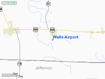
Walls Airport
Address: Lonoke County,
AR
Tel: 501-275-3466
Images and information placed
above are from
http://www.airport-data.com/airport/1AR1/
We
thank them for the data!
|
General Info |
| Country |
United
States |
| State |
ARKANSAS
|
| FAA
ID |
1AR1
|
| Latitude |
34-31-37.840N
|
| Longitude |
091-52-21.590W
|
| Elevation |
215
feet |
| Near
City |
COY
|
We don't guarantee the information is fresh and accurate. The data may be wrong or outdated.
For more up-to-date information please refer to other sources.
|
|


