 |
|
Texarkana Regional-webb Field Airport |
Texarkana Regional Airport
Webb Field |
 |
| 2000 USGS photo |
| IATA: TXK – ICAO: KTXK |
| Summary |
| Airport type |
Public |
| Operator |
Texarkana Airport Authority |
| Serves |
Texarkana, Arkansas / Texas |
| Location |
Texarkana, Arkansas |
| Elevation AMSL |
390 ft / 118.9 m |
| Coordinates |
33°27′13″N 93°59′28″W / 33.45361°N 93.99111°W / 33.45361; -93.99111Coordinates: 33°27′13″N 93°59′28″W / 33.45361°N 93.99111°W / 33.45361; -93.99111 |
| Runways |
| Direction |
Length |
Surface |
| ft |
m |
| 4/22 |
6,601 |
2,012 |
Asphalt |
| 13/31 |
5,200 |
1,585 |
Asphalt |
| Helipads |
| Number |
Length |
Surface |
| ft |
m |
| H1 |
60 |
18 |
Concrete |
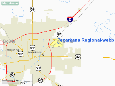
Texarkana Regional Airport (IATA: TXK, ICAO: KTXK), also known as Webb Field, is a public airport serving the Texarkana area, United States. The airport is located within the city limits of Texarkana, Arkansas, roughly 3 miles east of State Line Avenue. The front gate opens to the northwest, at the intersection of Arkansas Boulevard and U.S. Route 67. A Missouri Pacific Railroad line runs parallel to US 67 on the side of the highway facing the airport. Residents of Texarkana, Texas use this airport.
TXK has two runways and one helipad and is mostly used for general aviation, but is also served by one commercial airline. Airlines
| Airlines |
Destinations |
| American Eagle |
Dallas/Fort Worth |
The above content comes from Wikipedia and is published under free licenses – click here to read more.
Location
& QuickFacts
|
FAA Information Effective: |
2005-10-27 |
|
Airport Identifier: |
TXK |
|
Longitude/Latitude: |
093-59-27.7000W/33-27-13.4000N
-93.991028/33.453722 (Estimated) |
|
Elevation: |
390
ft / 118.87 m (Surveyed) |
|
Land: |
964
acres |
|
From nearest city: |
3
nautical miles NE of Texarkana, AR |
|
Location: |
Miller
County, AR |
|
Magnetic Variation: |
05E
(1985) |
Owner &
Manager
|
Ownership: |
Publicly
owned |
|
Owner: |
Texarkana
Arpt Authority |
|
Address: |
201
Airport Dr
Texarkana, AR 71854 |
|
Phone number: |
870-774-2171 |
|
Manager: |
Stephen
P. Luebbert |
|
Address: |
201
Airport Dr
Texarkana, AR 71854 |
|
Phone number: |
870-774-2171 |
Airport
Operations and Facilities
|
Airport Use: |
Open
to public |
|
Wind indicator: |
Yes |
|
Segmented Circle: |
Yes |
|
Control Tower: |
Yes |
|
Attendance Schedule: |
ALL/ALL/0600-2200 |
|
Lighting Schedule: |
DUSK-DAWN
WHEN ATCT CLSD ACTVT HIRL RY 04/22; MIRL RY 13/31; MALSR RY 22 &
PERIMETER LGTS H1 - CTAF. |
|
Beacon Color: |
Clear-Green
(lighted land airport) |
|
Landing fee charge: |
No |
|
Sectional chart: |
Memphis |
|
Region: |
ASW
- Southwest |
|
Traffic Pattern Alt: |
1200
ft |
|
Boundary ARTCC: |
ZFW
- Fort Worth |
|
Tie-in FSS: |
JBR
- Jonesboro |
|
FSS on Airport: |
No |
|
FSS Phone: |
870-935-3471 |
|
FSS Toll Free: |
1-800-WX-BRIEF |
|
NOTAMs Facility: |
TXK
(NOTAM-d service avaliable) |
|
Certification type/date: |
AS
5/1973 |
|
Federal Agreements: |
NGPXY3 |
Airport
Communication
Airport
Services
|
Fuel available: |
100LLA |
|
Airframe Repair: |
MAJOR |
|
Power Plant Repair: |
MAJOR |
|
Bottled Oxygen: |
HIGH |
Runway Information
Runway 04/22
|
Dimension: |
6601
x 144 ft / 2012.0 x 43.9 m |
|
Surface: |
ASPH,
Good Condition |
| Surface Treatment: |
Saw-cut
or plastic Grooved |
|
Weight Limit: |
Single
wheel: 50000 lbs.
Dual wheel: 86000 lbs.
Dual
tandem wheel: 120000 lbs. |
| Edge Lights: |
High |
|
|
Runway
04 |
Runway
22 |
|
Longitude: |
094-00-04.8808W |
093-59-09.8191W |
|
Latitude: |
33-26-46.5071N |
33-27-32.7076N |
|
Elevation: |
338.00
ft |
384.00
ft |
|
Alignment: |
45 |
127 |
|
ILS Type: |
|
ILS/DME
|
|
Traffic Pattern: |
Left |
Left |
|
Markings: |
Precision
instrument, Good Condition |
Precision
instrument, Good Condition |
|
Crossing Height: |
52.00
ft |
0.00
ft |
|
VASI: |
4-box
on left side |
|
|
Visual Glide Angle: |
3.00° |
0.00° |
| Approach lights: |
|
MALSR |
|
Obstruction: |
31 ft trees, 263.0 ft from runway, 505 ft left of centerline,
2:1 slope to clear |
17 ft trees, 358.0 ft from runway, 511 ft left of centerline,
9:1 slope to clear |
| Decleard distances: |
Take off run available 6601.00 ft
Take off distance available 6601.00 ft
Actual stop distance available 6601.00 ft
Landing distance available 6601.00 ft |
Take off run available 6601.00 ft
Take off distance available 6601.00 ft
Actual stop distance available 6601.00 ft
Landing distance available 6601.00 ft |
|
Runway 13/31
|
Dimension: |
5200
x 100 ft / 1585.0 x 30.5 m |
|
Surface: |
ASPH,
Good Condition |
| Surface Treatment: |
Saw-cut
or plastic Grooved |
|
Weight Limit: |
Single
wheel: 25000 lbs. |
| Edge Lights: |
Medium |
|
|
Runway
13 |
Runway
31 |
|
Longitude: |
093-59-37.1668W |
093-58-53.7734W |
|
Latitude: |
33-27-36.3458N |
33-26-59.9842N |
|
Elevation: |
361.00
ft |
386.00
ft |
|
Alignment: |
127 |
127 |
|
Traffic Pattern: |
Left |
Left |
|
Markings: |
Non-precision instrument, Good Condition |
Non-precision instrument, Good Condition |
|
Crossing Height: |
0.00
ft |
40.00
ft |
|
Displaced threshold: |
641.00
ft |
0.00
ft |
|
VASI: |
4-light PAPI on left side |
4-light PAPI on left side |
|
Visual Glide Angle: |
0.00° |
3.00° |
| Obstruction: |
15 ft road, 350.0 ft from runway, 10:1 slope to clear
+55 FT TREE 1215 FT; 475 FT LEFT; APCH RATIO 22:1 BASED ON
DSPLCD THR. |
40 ft tree, 1313.0 ft from runway, 239 ft right of
centerline, 27:1 slope to clear |
|
Decleard distances: |
Take off run available 5200.00 ft
Take off distance available 5200.00 ft
Actual stop distance available 5200.00 ft
Landing distance available 4559.00 ft |
Take off run available 5200.00 ft
Take off distance available 5200.00 ft
Actual stop distance available 4559.00 ft
Landing distance available 4559.00 ft |
|
Helipad H1
|
Dimension: |
60
x 60 ft / 18.3 x 18.3 m |
|
Surface: |
CONC,
Good Condition |
| Weight Limit: |
Single
wheel: 21000 lbs. |
|
|
Runway
H1 |
Runway
H |
| Traffic Pattern: |
Left |
Left |
|
Radio Navigation
Aids
| ID |
Type |
Name |
Ch |
Freq |
Var |
Dist |
| ATA |
NDB |
Atlanta |
|
347.00 |
04E |
23.3
nm |
|
HPC |
NDB |
Hope |
|
362.00 |
03E |
23.4
nm |
| VIV |
NDB |
Vivian |
|
284.00 |
06E |
35.7
nm |
|
DEQ |
NDB |
De
Queen |
|
281.00 |
04E |
41.0
nm |
| AGO |
NDB |
Magnolia |
|
266.00 |
04E |
41.3
nm |
|
SPH |
NDB |
Springhill |
|
375.00 |
05E |
43.4
nm |
| LST |
NDB |
Lone
Star |
|
305.00 |
05E |
49.3
nm |
|
TXK |
VORTAC |
Texarkana |
110X |
116.30 |
07E |
5.5
nm |
| EIC |
VORTAC |
Belcher |
121X |
117.40 |
07E |
42.0
nm |
Remarks
Texarkana
Regional-webb Field Airport
Address:
Miller
County, AR
Tel:
870-774-2171
Images and
information placed above are from
http://www.airport-data.com/airport/TXK/
We thank them for the data!
| General Info |
| Country |
United
States |
| State |
ARKANSAS
|
| FAA
ID |
TXK
|
| Latitude |
33-27-13.400N
|
| Longitude |
093-59-27.700W
|
| Elevation |
390
feet |
| Near
City |
TEXARKANA |
We don't guarantee the information is fresh and accurate. The data may be wrong or outdated.
For more up-to-date information please refer to other sources.
|
|


