 |
|
Stuttgart Municipal Airport |
| Stuttgart Municipal Airport |
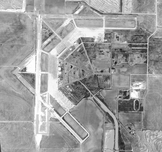 |
| USGS aerial image, 3 March 1994 |
| IATA: SGT – ICAO: KSGT – FAA LID: SGT |
| Summary |
| Airport type |
Public |
| Owner |
City of Stuttgart |
| Serves |
Stuttgart, Arkansas |
| Location |
Roc Roe Township, Prairie County |
| Elevation AMSL |
224 ft / 68 m |
| Coordinates |
34°35′58″N 091°34′30″W / 34.59944°N 91.575°W / 34.59944; -91.575 |
| Runways |
| Direction |
Length |
Surface |
| ft |
m |
| 9/27 |
5,002 |
1,525 |
Concrete |
| 18/36 |
6,015 |
1,833 |
Asphalt |
| Statistics (2008) |
| Aircraft operations |
40,200 |
| Based aircraft |
34 |
| Source: Federal Aviation Administration |
Stuttgart Municipal Airport (IATA: SGT, ICAO: KSGT, FAA LID: SGT) is a public-use airport located in Prairie County, Arkansas, United States. It is seven nautical miles (13 km) north of the central business district of Stuttgart, which owns the airport and is the county seat of Arkansas County. According to the FAA's National Plan of Integrated Airport Systems for 2009–2013, it is categorized as a general aviation facility. History
The airport was opened in October 1943 as Stuttgart Army Airfield by the United States Army Air Forcesand was used as an advanced twin engine aircraft training school during World War II. Stuttgart AAF was commanded by the 426th Army Air Force Base Unit, part of the AAF Southeast Training Center.
Improvements to the site included an airport with four 5,000 ft (1,500 m). runways and facilities for 6,000 personnel. The USAAF trained pilots in the use of gliders from October 1942 to May 1943 and twin-engine airplanes from May 1943 to December 1944 when the airfield was deactivated.
At the end of the war the airfield was determined to be excess by the War Department on 5 August 1946, 2,635.7 acres (10.666 km) were assumed by the War Assets Administration (WAA). Custody of the remaining 46.2 acres (187,000 m), which contained the housing units and the water and sewage facilities, was transferred to the Housing and Home Finance Agency, Public Housing Administration, on 31 January 1947.
In 1949, the WAA land and improvements were deeded to the City of Stuttgart, Arkansas, to establish the municipal airport. The city subsequently obtained the remaining 46.2 acres (187,000 m) from the Public Housing Administration and now owns the entire 2,681.9 acres (10.853 km) used in connection with the former Stuttgart AAF. The transfer included a recapture clause by which the Government reserved specific rights of use and possession during a national emergency.
Facilities and aircraft
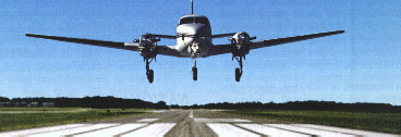
Stuttgart Municipal Airport covers an area of 2,560 acres (1,036 ha) at an elevation of 224 feet (68 m) above mean sea level. It has two runways: 9/27 is 5,002 by 150 feet (1,525 x 46 m) with a concrete surface; 18/36 is 6,015 by 100 feet (1,833 x 30 m) with an asphalt surface.
For the 12-month period ending June 30, 2008, the airport had 40,200 aircraft operations, an average of 110 per day: 87% general aviation, 7.5% military, and 5.5% air taxi. At that time there were 34 aircraft based at this airport: 82% single-engine, 12% multi-engine, 3% jet and 3% helicopter.
Motorsports
A 3-mile (4.8 km) SCCA road course was designed using the runways, with the first race in 1959. The last sports car race was held in 1978. A drag strip also existed from 1970 to 1972, operating as Stuttgart Dragway.
The above content comes from Wikipedia and is published under free licenses – click here to read more.
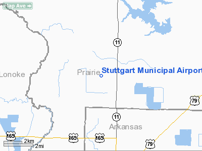
Located in the Grand Prairie Region of Arkansas, the airport
is situated on a 2,560 acre site in southeastern Paririe County. (Known
for its agricultural industries, the Grand Prairie Region's best known
agricultural product is rice.) Located in adjoining Arkansas County, the
City of Stuttgart owns and operates the airport.
The airport is located 7.2 miles north of the City of
Stuttgart along State Highway 11. Two U.S. Highways, Highways 79 and 165,
converge at Stuttgart. Highway 79 connects Stuttgart with Memphis, Tennessee
to the northeast and Pine Bluff, Arkansas to the southwest. U.S. Highway
165 connects Stuttgart with the state's capitol city, Little Rock, 50
miles to the northwest.
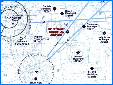 Although there is no air traffic control tower on the airport,
the unicom frequency of 122.8 mhz is used by aircraft in the vicinity
of the airport to obtain airport information and advise other aircraft
of their position and intentions. Aircraft arriving and departing the
airport under Instrument Flight Rules (IFR) as well as participating aircraft
operating under Visual Flight Rules (VFR) are handled by the Little Rock-Adams
Field Approach Control, via 123.7 mhz, which controls aircraft from ground
surface up to 15,000 feet. All aircraft operating on IFR flight plans
and those VFR aircraft that have established radio communication with
the Little Rock-Adams Field Approach Control will be provided with altitude
separation and route guidance to their destination airport. The Little
Rock-Adams Field approach control directs aircraft along Victor airways
until they are established on an instrument approach (when flying IFR)
or have visual contact with the airport (when flying VFR). The Memphis
Air Route Traffic Control Center directs aircraft along jet routes. Although there is no air traffic control tower on the airport,
the unicom frequency of 122.8 mhz is used by aircraft in the vicinity
of the airport to obtain airport information and advise other aircraft
of their position and intentions. Aircraft arriving and departing the
airport under Instrument Flight Rules (IFR) as well as participating aircraft
operating under Visual Flight Rules (VFR) are handled by the Little Rock-Adams
Field Approach Control, via 123.7 mhz, which controls aircraft from ground
surface up to 15,000 feet. All aircraft operating on IFR flight plans
and those VFR aircraft that have established radio communication with
the Little Rock-Adams Field Approach Control will be provided with altitude
separation and route guidance to their destination airport. The Little
Rock-Adams Field approach control directs aircraft along Victor airways
until they are established on an instrument approach (when flying IFR)
or have visual contact with the airport (when flying VFR). The Memphis
Air Route Traffic Control Center directs aircraft along jet routes.
A Remote Transmitter Receiver (RTR) is available
for pilots using the airport. The RTR operates at 123.7 mhz and provides
for ground-to-ground communications between the Little Rock-Adams Field,
FAA, ATCT, and pilots at the airport when delivering enroute clearances,
issuing departure authorizations, and acknowledging flight plan cancellations
or departure and landing times.
 The airport's aircraft fueling facilities consist of fuel pumps
and underground tanks located on the apron in front of the Berry Administration
Building. Separate jet fuel and 100LL tanks and pumps are provided. Fuel
storage capability totals 15,100 gallons: 10,100 gallons of jet fuel and
5,000 gallons of 100LL aviation fuel. The airport's aircraft fueling facilities consist of fuel pumps
and underground tanks located on the apron in front of the Berry Administration
Building. Separate jet fuel and 100LL tanks and pumps are provided. Fuel
storage capability totals 15,100 gallons: 10,100 gallons of jet fuel and
5,000 gallons of 100LL aviation fuel.
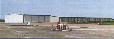
Two T-hangar facilities located north of
the Berry Administration Building provide enclosed aircraft storage for
a portion of the 32 aircraft based at the airport. A total of 18 hangar
positions are provided in the two buildings.
 Two runways are available for use at the airport; Runway 18-36
and Runway 9-27, both dimensioned the same. Each runway is 5,002 feet
long, 150 feet wide and constructed of concrete. The weight bearing capacity
of each runway can accommodate all general aviation and business jet aircraft
currently in the national fleet. Two runways are available for use at the airport; Runway 18-36
and Runway 9-27, both dimensioned the same. Each runway is 5,002 feet
long, 150 feet wide and constructed of concrete. The weight bearing capacity
of each runway can accommodate all general aviation and business jet aircraft
currently in the national fleet.
Runways are marked in accordance with the
type of approach procedure utilized to the runway. Due to existing NDB
nonprecision approach to Runway 18-36, it has nonprecision markings. Nonprecision
markings identify the runway centerline, designation, threshold, and aircraft
holding positions. Because of the existing visual approaches to Runway
9-27, it has basic markings. Basic markings identify the runway centerline,
designation, and aircraft holding positions.
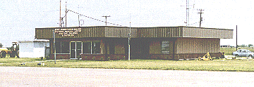 The
Berry Adminstration Building is located approximately midfield of Runway
18-36 along the east side of the aircraft parking apron. Within the Berry
Adminstration Building is a pilot lounge and public waiting area, restrooms,
vending machines, and airport manager's office. City staff currently provides
the traditional Fixed Based Operator (FBO) services at the airport. This
includes fuel and line services for local as well as transient aircraft.
Presently, no aircraft maintenance services are provided at the airport. The
Berry Adminstration Building is located approximately midfield of Runway
18-36 along the east side of the aircraft parking apron. Within the Berry
Adminstration Building is a pilot lounge and public waiting area, restrooms,
vending machines, and airport manager's office. City staff currently provides
the traditional Fixed Based Operator (FBO) services at the airport. This
includes fuel and line services for local as well as transient aircraft.
Presently, no aircraft maintenance services are provided at the airport.
Location
& QuickFacts
|
FAA Information Effective: |
2005-10-27 |
|
Airport Identifier: |
SGT |
|
Longitude/Latitude: |
091-34-29.8400W/34-35-58.2900N
-91.574956/34.599525 (Estimated) |
|
Elevation: |
224
ft / 68.28 m (Surveyed) |
|
Land: |
2560
acres |
|
From nearest city: |
7
nautical miles N of Stuttgart, AR |
|
Location: |
Prairie
County, AR |
|
Magnetic Variation: |
02E
(2000) |
Owner &
Manager
|
Ownership: |
Publicly
owned |
|
Owner: |
City
Of Stuttgart |
|
Address: |
514
S Main
Stuttgart, AR 72160 |
|
Phone number: |
870-673-4566 |
| Url: |
http://www.ar-net.com/sttg/sma/index.html |
|
Manager: |
Carl Humphrey |
|
Address: |
City
Hall 514 S Main St
Stuttgart, AR 72160 |
| Email: |
jcarlh@usa.net
|
|
Phone number: |
870-673-2960 |
Airport
Operations and Facilities
|
Airport Use: |
Open
to public |
|
Wind indicator: |
Yes |
|
Segmented Circle: |
No |
|
Control Tower: |
No |
|
Attendance Schedule: |
NOV-JAN/ALL/0800-1900,FEB-OCT/ALL/0800-1700 |
|
Lighting Schedule: |
DUSK-DAWN
ACTVT MIRL RYS 09/27 & 18/36 - CTAF. |
|
Beacon Color: |
Clear-Green
(lighted land airport) |
|
Landing fee charge: |
No |
|
Sectional chart: |
Memphis |
|
Region: |
ASW
- Southwest |
|
Boundary ARTCC: |
ZME
- Memphis |
|
Tie-in FSS: |
JBR
- Jonesboro |
|
FSS on Airport: |
No |
|
FSS Phone: |
870-935-3471 |
|
FSS Toll Free: |
1-800-WX-BRIEF |
|
NOTAMs Facility: |
SGT
(NOTAM-d service avaliable) |
|
Federal Agreements: |
NGY |
Airport
Communications
| CTAF: |
122.800 |
|
Unicom: |
122.800
|
Airport
Services
|
Fuel available: |
100LLA
FOR FUEL NIGHTS CALL 870-673-2360. |
|
Airframe Repair: |
MINOR |
|
Power Plant Repair: |
MINOR |
|
Bulk Oxygen: |
NONE |
Runway
Information
Runway
09/27
|
Dimension: |
5002
x 150 ft / 1524.6 x 45.7 m |
|
Surface: |
CONC,
Good Condition |
| Weight Limit: |
Single
wheel: 25000 lbs.
Dual wheel: 65000 lbs.
Dual
tandem wheel: 120000 lbs. |
|
Edge Lights: |
Medium |
| |
Runway 09 |
Runway 27 |
|
Longitude: |
091-34-43.4470W |
091-33-43.6452W |
| Latitude: |
34-36-14.3178N |
34-36-12.7246N |
|
Elevation: |
220.00
ft |
219.00
ft |
| Alignment: |
92 |
127 |
|
Traffic Pattern: |
Left |
Left |
| Markings: |
Basic,
Good Condition |
Basic,
Good Condition |
|
Runway
18/36
|
Dimension: |
6015
x 100 ft / 1833.4 x 30.5 m |
|
Surface: |
ASPH-CONC,
Good Condition |
| Surface Treatment: |
Saw-cut
or plastic Grooved |
|
Weight Limit: |
Single
wheel: 75000 lbs.
Dual wheel: 150000 lbs.
Dual tandem wheel: 200000 lbs.
Dual dual tandem wheel: 300000 lbs. |
| Edge Lights: |
Medium |
| |
Runway 18 |
Runway 36 |
|
Longitude: |
091-34-42.5210W |
091-34-44.8485W |
| Latitude: |
34-36-15.0503N |
34-35-15.5847N |
|
Elevation: |
220.00
ft |
223.00
ft |
| Alignment: |
127 |
2 |
|
ILS Type: |
|
ILS/DME
|
| Traffic Pattern: |
Left |
Left |
|
Markings: |
Non-precision instrument, Good Condition |
Non-precision instrument, Good Condition |
| Crossing Height: |
0.00
ft |
27.00
ft |
|
VASI: |
|
2-light PAPI on left side |
| Visual Glide Angle: |
0.00° |
3.00° |
|
Runway End Identifier: |
Yes |
Yes |
| Obstruction: |
,
50:1 slope to clear |
35 ft pline, 1750.0 ft from runway, 43:1 slope to clear |
|
Radio Navigation
Aids
|
ID |
Type |
Name |
Ch |
Freq |
Var |
Dist |
| SGT |
NDB |
Stuttgart |
|
269.00 |
02E |
4.0
nm |
|
BKZ |
NDB |
Brinkley |
|
242.00 |
02E |
25.9
nm |
| TYV |
NDB |
Toneyville |
|
290.00 |
04E |
30.5
nm |
|
SRC |
NDB |
Searcy |
|
323.00 |
02E |
37.6
nm |
| HEE |
NDB |
Thompson-robbins |
|
251.00 |
01E |
44.5
nm |
|
FCY |
NDB |
Forrest
City |
|
332.00 |
01E |
44.6
nm |
| LRF |
TACAN |
Jacksonville |
029X |
|
04E |
34.6
nm |
|
PBF |
VOR/DME |
Pine
Bluff |
107X |
116.00 |
04E |
27.4
nm |
| UJM |
VOR/DME |
Marvell |
033X |
109.60 |
01E |
44.6
nm |
|
LIT |
VORTAC |
Little
Rock |
086X |
113.90 |
05E |
30.3
nm |
Remarks
- MIGRATORY BIRDS ON &
INVOF ARPT NOV-FEB.
- NUMEROUS AGRICULTURAL
ACFT OPNS FROM FEB-NOV 500' AGL AND BELOW.
Stuttgart
Municipal Airport
Address:
Prairie County,
AR
Tel: 870-673-2960
E-mail: jcarlh@usa.net
URL: http://www.ar-net.com/sttg/sma/index.html
Images
and information placed above are from
http://www.ar-net.com/sttg/sma/index.html
http://www.airport-data.com/airport/SGT/
We
thank them for the data!
|
General Info |
| Country |
United
States |
| State |
ARKANSAS
|
| FAA
ID |
SGT
|
| Latitude |
34-35-58.290N
|
| Longitude |
091-34-29.840W
|
| Elevation |
224
feet |
| Near
City |
STUTTGART
|
We don't guarantee the information is fresh and accurate. The data may be wrong or outdated.
For more up-to-date information please refer to other sources.
|
|


