|
|
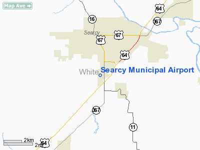
Searcy, Arkansas, located just 45 miles
Northeast of Little rock, is one of the fastest growing communities in the
State. Searcy enjoys the benefits of a very diverse economy and the airport
is proud ot be able to attend to the wants and needs of the citizens that
make up this city and the businesses that utilize this facility.
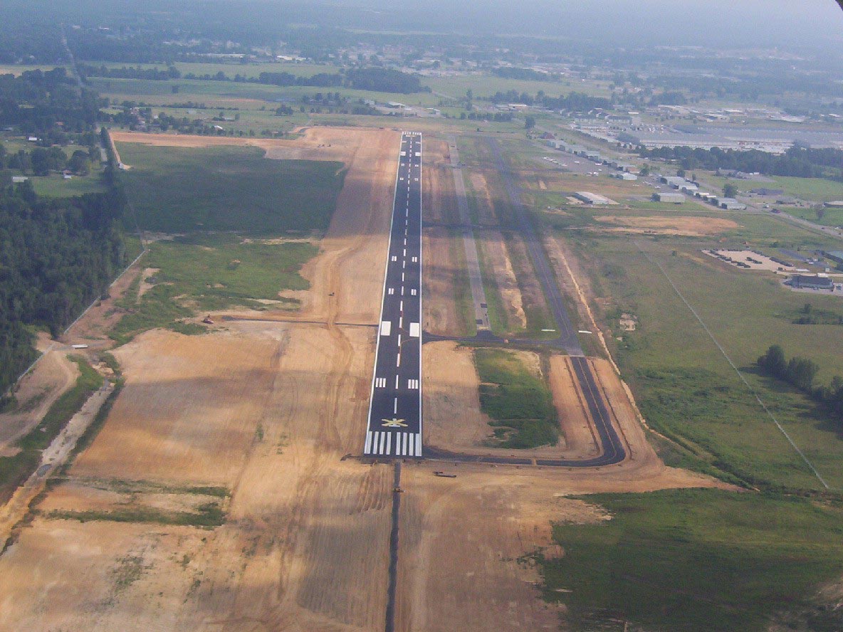
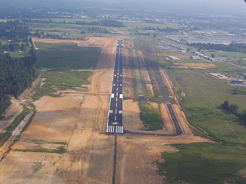
The Searcy Municipal Airport has completed
an eight million dollar expansion project that has extended the runway
to 6008 ft and widened to 100 ft. wide. The project also has seen the
installation of the new Instrument Landing System! The ILS will enhance
safety of arrivals when Searcy is experiencing inclement weather. This
modernization has put Searcy at the forefront of GA airports and better
serves the general aviation community. A new taxiway has also been completed
allowing more space for new hangar construction. Other projects are either
ongoing and/or being planned.
|
 |
(Click on the photo to
enlarge) |
Location
& QuickFacts
| FAA
Information Effective: |
2005-10-27 |
| Airport
Identifier: |
SRC |
| Longitude/Latitude: |
091-44-15.1420W/35-12-38.1950N
-91.737539/35.210610 (Estimated) |
| Elevation: |
264
ft / 80.47 m (Surveyed) |
| Land: |
330 acres |
| From
nearest city: |
3
nautical miles S of Searcy, AR |
| Location: |
White County, AR |
| Magnetic
Variation: |
02E
(1995) |
Owner &
Manager
| Ownership: |
Publicly owned |
| Owner: |
City
Of Searcy |
| Address: |
2609
South Main Street
Searcy,
AR 72143 |
| Phone
number: |
501-279-1080 |
| Fax: |
501-279-1081 |
| Url: |
http://www.cityofsearcy.org/airport/index.asp
|
| Manager: |
Brett Lund |
| Email: |
brett.lund@cityofseracy.org
|
| Address: |
2609 S Main
Searcy, AR 72143 |
| Phone
number: |
501-279-1080 |
Airport
Operations and Facilities
| Airport
Use: |
Open to public |
| Wind
indicator: |
Yes |
| Segmented
Circle: |
No |
| Control
Tower: |
No |
| Attendance
Schedule: |
ALL/ALL/DALGT |
| Lighting
Schedule: |
DUSK-DAWN
MIRL RY 01/19 PRESET LOW INTST; TO INCR INTST ACTVT - CTAF. |
| Beacon
Color: |
Clear-Green
(lighted land airport) |
| Landing
fee charge: |
No |
| Sectional
chart: |
Memphis |
| Region: |
ASW
- Southwest |
| Traffic
Pattern Alt: |
800 ft |
| Boundary
ARTCC: |
ZME
- Memphis |
| Tie-in
FSS: |
JBR - Jonesboro |
| FSS
on Airport: |
No |
| FSS
Phone: |
870-935-3471 |
| FSS
Toll Free: |
1-800-WX-BRIEF |
| NOTAMs
Facility: |
SRC
(NOTAM-d service avaliable) |
| Federal
Agreements: |
NGY |
Airport
Communications
| CTAF: |
122.700 |
|
Unicom: |
122.700
|
Airport
Services
Searcy
Municipal Airport is an AV Fuel dealer. Jet A is premixed with Anti-Icing
Addictive FS11.
| Fuel
available: |
100LLA
FOR FUEL AFT HRS CALL 501-279-1080. |
| Airframe
Repair: |
MAJOR |
| Power
Plant Repair: |
MAJOR |
| Bottled
Oxygen: |
NONE |
| Bulk
Oxygen: |
NONE |
Runway
Information
Runway
01/19
| Dimension: |
6008 x
100 ft / 1831.2 x 30.5 m |
| Surface: |
ASPH, Good Condition |
| Weight Limit: |
Single wheel: 24000 lbs.
|
| Edge
Lights: |
Medium |
| |
Runway 01 |
Runway 19 |
| Longitude: |
091-44-23.0577W |
091-44-07.2136W |
| Latitude: |
35-12-09.1951N |
35-13-07.1708N |
| Elevation: |
235.00 ft |
264.00 ft |
| Alignment: |
13 |
127 |
| ILS
Type: |
ILS/DME
|
|
| Traffic Pattern: |
Left |
Left |
| Markings: |
Non-precision
instrument, Good Condition |
Non-precision
instrument, Good Condition |
| Crossing
Height: |
41.00 ft |
51.00 ft |
| VASI: |
4-light
PAPI on left side |
4-light
PAPI on left side |
| Visual Glide
Angle: |
3.00° |
3.00° |
| Runway
End Identifier: |
|
Yes |
| Obstruction: |
, 50:1 slope to clear |
15 ft tree,
650.0 ft from runway, 300 ft left of centerline, 30:1 slope
to clear |
|
Radio Navigation
Aids
|
ID |
Type |
Name |
Ch |
Freq |
Var |
Dist |
| SRC |
NDB |
Searcy |
|
323.00 |
02E |
0.3 nm |
| TYV |
NDB |
Toneyville |
|
290.00 |
04E |
20.8 nm |
| HBZ |
NDB |
Heber Springs |
|
256.00 |
03E |
22.7 nm |
| INY |
NDB |
Independence County |
|
317.00 |
03E |
29.9 nm |
| SGT |
NDB |
Stuttgart |
|
269.00 |
02E |
33.6 nm |
| BKZ |
NDB |
Brinkley |
|
242.00 |
02E |
33.9 nm |
| CWS |
NDB |
Conway |
|
302.00 |
05E |
34.7 nm |
| EWP |
NDB |
Newport |
|
400.00 |
04E |
37.6 nm |
| VLX |
NDB |
Wilcox |
|
348.00 |
02E |
43.2 nm |
| BDQ |
NDB |
Bridge |
|
208.00 |
04E |
48.1 nm |
| LRF |
TACAN |
Jacksonville |
029X |
|
04E |
27.1 nm |
| LIT |
VORTAC |
Little Rock |
086X |
113.90 |
05E |
38.8 nm |
Remarks
- NUMEROUS AGRICULTURAL
ACFT OPNS FM FEB-NOV 500 FT AGL & BLO.
- NUMEROUS GYROCOPTER OPNS
DALGT HRS.
- NUMEROUS STUDENT PILOT OPNS.
- NO LINE OF SIGHT BTN
RY ENDS - SMALL ACFT.
- PAEW ADJ TO RYS &
TWYS.
Searcy Municipal Airport
2609 South Main Street
Searcy, AR 72143
Tel (501) 279-1080
Fax: (501) 279-2816
E-mail: brett.lund@cityofseracy.org
URL: http://www.cityofsearcy.org/airport/index.asp
Images
and information placed above are from
http://www.cityofsearcy.org/airport/index.asp
http://www.airport-data.com/airport/SRC/
We
thank them for the data!
|
General Info |
| Country |
United
States |
| State |
ARKANSAS
|
| FAA
ID |
SRC
|
| Latitude |
35-12-43.007N
|
| Longitude |
091-44-13.794W
|
| Elevation |
264
feet |
| Near
City |
SEARCY
|
We don't guarantee the information is fresh and accurate. The data may be wrong or outdated.
For more up-to-date information please refer to other sources.
|
|