 |
|
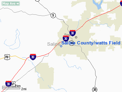
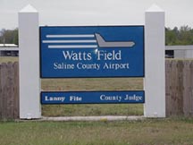
Saline County / watts Field Airport |
Saline County Airport
Watts Field |
| IATA: none – ICAO: none – FAA LID: M99 |
| Summary |
| Airport type |
Public |
| Owner |
Saline County |
| Serves |
Benton, Arkansas |
| Elevation AMSL |
318 ft / 97 m |
| Coordinates |
34°33′24″N 092°36′25″W / 34.55667°N 92.60694°W / 34.55667; -92.60694 |
| Website |
www.salinecounty.org/... |
| Runways |
| Direction |
Length |
Surface |
| ft |
m |
| 17/35 |
3,980 |
1,213 |
Asphalt |
| Statistics (2006) |
| Aircraft operations |
39,000 |
| Based aircraft |
44 |
| Source: Federal Aviation Administration |
Saline County Airport (FAA LID: M99), also known as Watts Field, was a county-owned public-use airport located one mile (2 km) west of the central business district of Benton, a city in Saline County, Arkansas, United States. The airport's address was 401 Airline Drive in Benton.
The airport opened in 1957. Construction on the new Saline County Regional Airport (ICAO: KSUZ, FAA LID: SUZ) began in November 2002 and it opened on March 12, 2007. The existing was closed after the new airport opened.
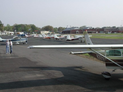
Facilities and aircraft
Saline County Airport covered an area of 72 acres (29 ha) which contained one runway designated 17/35 with a 3,980 x 50 ft (1,213 x 15 m) asphalt surface. For the 12-month period ending August 31, 2006, the airport had 39,000 aircraft operations, an average of 106 per day: 99% general aviation and 1% military. At that time there were 44 aircraft based at this airport: 95% single-engine and 5% helicopter.
The above content comes from Wikipedia and is published under free licenses – click here to read more.
Location
& QuickFacts
|
FAA Information Effective: |
2005-10-27 |
|
Airport Identifier: |
M99 |
|
Longitude/Latitude: |
092-36-24.9830W/34-33-23.6330N
-92.606940/34.556565 (Estimated) |
|
Elevation: |
318
ft / 96.93 m (Surveyed) |
|
Land: |
72
acres |
|
From nearest city: |
1
nautical miles W of Benton, AR |
|
Location: |
Saline
County, AR |
|
Magnetic Variation: |
03E
(2000) |
Owner &
Manager
|
Ownership: |
Publicly
owned |
|
Owner: |
Saline
County |
|
Address: |
401
Airline Dr., Benton, AR 72015 |
|
Phone number: |
501-303-5657 |
|
Fax: |
501-303-5611 |
|
Url: |
http://www.salinecounty.org/airport.htm
|
|
Manager: |
Mark
Westbrook
COMMISSION CHAIRMAN. |
|
Mailing Address: |
Saline County Airport Commission,
P.
O. Box 1628, Benton, AR 72018 |
|
Phone number: |
501-303-5690 |
|
Email: |
sitemaster@salinecounty.org
|
Airport
Operations and Facilities
|
Airport Use: |
Open
to public |
|
Wind indicator: |
Yes |
|
Segmented Circle: |
No |
|
Control Tower: |
No |
|
Attendance Schedule: |
ALL/ALL/0700-1700 |
|
Lighting Schedule: |
DUSK-DAWN
ACTVT MIRL RY 17/35 - CTAF. |
|
Beacon Color: |
Clear-Green
(lighted land airport) |
|
Landing fee charge: |
No |
|
Sectional chart: |
Memphis |
|
Region: |
ASW
- Southwest |
|
Boundary ARTCC: |
ZME
- Memphis |
|
Tie-in FSS: |
JBR
- Jonesboro |
|
FSS on Airport: |
No |
|
FSS Phone: |
870-935-3471 |
|
FSS Toll Free: |
1-800-WX-BRIEF |
|
NOTAMs Facility: |
JBR
(NOTAM-d service avaliable) |
|
Federal Agreements: |
NGY |
Airport
Communications
| CTAF: |
122.800 |
|
Unicom: |
122.800
|
Airport
Services
|
Airframe Repair: |
MINOR |
|
Power Plant Repair: |
MINOR |
|
Bottled Oxygen: |
NONE |
|
Bulk Oxygen: |
NONE |
Runway
Information
Runway
17/35
|
Dimension: |
3980
x 50 ft / 1213.1 x 15.2 m |
|
Surface: |
ASPH,
Good Condition |
| Weight Limit: |
Single
wheel: 11000 lbs. |
|
Edge Lights: |
Medium
MIRL OTS INDEFLY. |
| |
Runway 17 |
Runway 35 |
|
Longitude: |
092-36-25.5420W |
092-36-24.4230W |
| Latitude: |
34-33-41.7670N |
34-33-05.4570N |
|
Elevation: |
318.00
ft |
285.00
ft |
| Alignment: |
127 |
127 |
|
Traffic Pattern: |
Right |
Left |
| Markings: |
Basic,
Good Condition |
Basic,
Good Condition |
|
Displaced threshold: |
365.00
ft |
289.00
ft |
| Obstruction: |
40 ft pole, 225.0 ft from runway, 112 ft left of centerline
APCH SLOPE 14:1 FM DSPLCD THLD.
+5'
FENCE 140' FROM THR. |
20 ft tree, 450.0 ft from runway, 120 ft right of centerline,
12:1 slope to clear
APCH SLOPE 36:1 FM DSPLCD THLD.
+10
FT ROAD AT 120 FT ON CNTRLN. |
|
Radio Navigation
Aids
|
ID |
Type |
Name |
Ch |
Freq |
Var |
Dist |
| MVQ |
NDB |
Malvern |
|
215.00 |
04E |
15.5
nm |
|
HO |
NDB |
Hossy |
|
385.00 |
04E |
30.0
nm |
| CWS |
NDB |
Conway |
|
302.00 |
05E |
32.9
nm |
|
BDQ |
NDB |
Bridge |
|
208.00 |
04E |
35.4
nm |
| MPJ |
NDB |
Morrilton |
|
410.00 |
07E |
37.3
nm |
|
TYV |
NDB |
Toneyville |
|
290.00 |
04E |
37.5
nm |
| ADF |
NDB |
Arkadelphia |
|
275.00 |
02E |
39.0
nm |
|
RUE |
NDB |
Russellville |
|
379.00 |
03E |
48.5
nm |
| LRF |
TACAN |
Jacksonville |
029X |
|
04E |
31.1
nm |
|
HOT |
VOR/DME |
Hot
Springs |
037X |
110.00 |
04E |
24.4
nm |
| PBF |
VOR/DME |
Pine
Bluff |
107X |
116.00 |
04E |
38.6
nm |
|
LIT |
VORTAC |
Little Rock |
086X |
113.90 |
05E |
22.3 nm |
Remarks
- PARALLEL TWY CLSD TO
TWIN ENGINE & LARGER ACFT.
Saline County/watts
Field Airport
Located at:
401 Airline Dr., Benton, AR 72015
Mailing Address:
P. O. Box 1628, Benton, AR 72018
Phone: 501-303-5657 (Courthouse)
Fax: 501-303-5611 (Courthouse)
URL: http://www.salinecounty.org/airport.htm
E-mail: sitemaster@salinecounty.org
Images
and information placed above are from
http://www.airport-data.com/airport/M99/
http://www.salinecounty.org/airport.htm
We
thank them for the data!
|
General Info |
| Country |
United
States |
| State |
ARKANSAS
|
| FAA
ID |
M99
|
| Latitude |
34-33-23.633N
|
| Longitude |
092-36-24.983W
|
| Elevation |
318
feet |
| Near
City |
BENTON
|
We don't guarantee the information is fresh and accurate. The data may be wrong or outdated.
For more up-to-date information please refer to other sources.
|
|


