 |
|
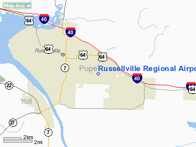
Russellville Regional Airport |
Location
& QuickFacts
|
FAA Information Effective: |
2005-10-27 |
|
Airport Identifier: |
RUE |
|
Longitude/Latitude: |
093-05-35.7580W/35-15-32.9280N
-93.093266/35.259147 (Estimated) |
|
Elevation: |
403
ft / 122.83 m (Surveyed) |
|
Land: |
307
acres |
|
From nearest city: |
2
nautical miles SE of Russellville, AR |
|
Location: |
Pope
County, AR |
|
Magnetic Variation: |
03E
(1995) |
Owner &
Manager
|
Ownership: |
Publicly
owned |
|
Owner: |
City
Of Russellville |
|
Address: |
Po
Box 428
Russellville, AR 72801 |
|
Phone number: |
479-968-2098 |
|
Manager: |
Bill
Shelton |
|
Address: |
1759
Airport Road
Russellville, AR 72802 |
|
Phone number: |
479-967-1227 |
Airport
Operations and Facilities
|
Airport Use: |
Open
to public |
|
Wind indicator: |
Yes |
|
Segmented Circle: |
Yes |
|
Control Tower: |
No |
|
Attendance Schedule: |
ALL/ALL/0800-DUSK
FOR SVC AFT HRS CALL 479-331-3318 OR 479-857-4074. |
|
Lighting Schedule: |
DUSK-DAWN
ACTVT VASI RY 07 - CTAF. |
|
Beacon Color: |
Clear-Green
(lighted land airport) |
|
Landing fee charge: |
No |
|
Sectional chart: |
Memphis |
|
Region: |
ASW
- Southwest |
|
Traffic Pattern Alt: |
1005
ft |
|
Boundary ARTCC: |
ZME
- Memphis |
|
Tie-in FSS: |
JBR
- Jonesboro |
|
FSS on Airport: |
No |
|
FSS Phone: |
870-935-3471 |
|
FSS Toll Free: |
1-800-WX-BRIEF |
|
NOTAMs Facility: |
RUE
(NOTAM-d service avaliable) |
|
Federal Agreements: |
NGY |
Airport
Communications
|
CTAF: |
122.700 |
|
Unicom: |
122.700
|
Airport
Services
|
Fuel available: |
100LLA |
|
Airframe Repair: |
MAJOR |
|
Power Plant Repair: |
MAJOR |
|
Bottled Oxygen: |
NONE |
|
Bulk Oxygen: |
NONE |
Runway
Information
Runway
07/25
|
Dimension: |
5094
x 75 ft / 1552.7 x 22.9 m |
|
Surface: |
ASPH,
Good Condition |
| Weight Limit: |
Single
wheel: 32000 lbs.
Dual wheel: 46000 lbs. |
|
Edge Lights: |
Medium |
| |
Runway 07 |
Runway 25 |
|
Longitude: |
093-06-05.4300W |
093-05-06.0860W |
| Latitude: |
35-15-26.4270N |
35-15-39.4280N |
|
Elevation: |
367.00
ft |
403.00
ft |
| Alignment: |
75 |
127 |
|
Traffic Pattern: |
Left |
Left |
| Markings: |
Non-precision instrument, Good Condition |
Non-precision instrument, Good Condition |
|
Crossing Height: |
49.00
ft |
0.00
ft |
| Displaced threshold: |
0.00
ft |
300.00
ft |
|
VASI: |
2-box
on left side |
|
| Visual Glide Angle: |
3.00° |
0.00° |
|
Obstruction: |
58 ft tree, 2220.0 ft from runway, 34:1 slope to clear |
50 ft tree, 1397.0 ft from runway, 300 ft right of
centerline, 23:1 slope to clear
APCH SLOPE 33:1 TO DSPLCD THLD. |
|
Radio Navigation
Aids
|
ID |
Type |
Name |
Ch |
Freq |
Var |
Dist |
| RUE |
NDB |
Russellville |
|
379.00 |
03E |
0.1
nm |
|
MPJ |
NDB |
Morrilton |
|
410.00 |
07E |
11.8
nm |
| BDQ |
NDB |
Bridge |
|
208.00 |
04E |
20.0
nm |
|
CZE |
NDB |
Clarksville |
|
201.00 |
04E |
20.5
nm |
| CWS |
NDB |
Conway |
|
302.00 |
05E |
34.4
nm |
|
HOT |
VOR/DME |
Hot
Springs |
037X |
110.00 |
04E |
46.9
nm |
Remarks
- FLOCKS OF MIGRATORY BIRDS
INVOF ARPT.
- DEER ON & INVOF RY.
- PAEW ON BOTH SIDES OF
RY.
- RY 07 MARKINGS NSTD.
Russellville Regional
Airport
Address:
Pope County, AR
Tel: 479-967-1227
Images and information placed
above are from
http://www.airport-data.com/airport/RUE/
We
thank them for the data!
|
General Info |
| Country |
United
States |
| State |
ARKANSAS
|
| FAA
ID |
RUE
|
| Latitude |
35-15-32.928N
|
| Longitude |
093-05-35.758W
|
| Elevation |
403
feet |
| Near
City |
RUSSELLVILLE
|
We don't guarantee the information is fresh and accurate. The data may be wrong or outdated.
For more up-to-date information please refer to other sources.
|
|


