|
|

|
 |
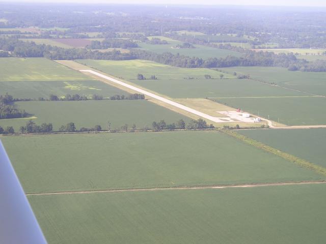
Approaching from the northeast
(Click on the photo to enlarge) |
Location
& QuickFacts
|
FAA Information Effective: |
2005-10-27 |
|
Airport Identifier: |
7M8 |
|
Longitude/Latitude: |
090-19-10.3640W/36-15-00.2270N
-90.319546/36.250063 (Estimated) |
|
Elevation: |
281
ft / 85.65 m (Estimated) |
|
Land: |
29
acres |
|
From nearest city: |
2
nautical miles SW of Rector, AR |
|
Location: |
Clay
County, AR |
|
Magnetic Variation: |
02E
(1985) |
Owner &
Manager
|
Ownership: |
Publicly
owned |
|
Owner: |
City
Of Rector |
|
Address: |
125
Front St.
Rector, AR 72461 |
|
Phone number: |
870-595-2423 |
|
Manager: |
Duane
Deniston |
|
Address: |
125
Front St.
Rector, AR 72461 |
|
Phone number: |
870-595-2423 |
Airport
Operations and Facilities
|
Airport Use: |
Open
to public |
|
Wind indicator: |
Yes |
|
Segmented Circle: |
No |
|
Control Tower: |
No |
|
Attendance Schedule: |
UNATNDD |
|
Lighting Schedule: |
DUSK-DAWN
ACTVT MIRL RY 18/36 - CTAF. |
|
Beacon Color: |
Clear-Green
(lighted land airport) |
|
Landing fee charge: |
No |
|
Sectional chart: |
St
Louis |
|
Region: |
ASW
- Southwest |
|
Boundary ARTCC: |
ZME
- Memphis |
|
Tie-in FSS: |
JBR
- Jonesboro |
|
FSS on Airport: |
No |
|
FSS Phone: |
870-935-3471 |
|
FSS Toll Free: |
1-800-WX-BRIEF |
|
NOTAMs Facility: |
JBR
(NOTAM-d service avaliable) |
Airport
Communications
Airport
Services
|
Airframe Repair: |
NONE |
|
Power Plant Repair: |
NONE |
|
Bottled Oxygen: |
NONE |
|
Bulk Oxygen: |
NONE |
Runway
Information
Runway
18/36
|
Dimension: |
3405
x 60 ft / 1037.8 x 18.3 m |
|
Surface: |
ASPH,
Fair Condition |
| Weight Limit: |
Single
wheel: 5000 lbs. |
|
Edge Lights: |
Medium |
| |
Runway 18 |
Runway 36 |
|
Traffic Pattern: |
Left |
Left |
| Markings: |
Nonstandard, Poor Condition
RY 18/36 NPI MARKINGS INCORRECT SIZE & SPACING.
RY 18/36 MARKINGS FADED. |
Nonstandard,
Poor Condition |
|
Displaced threshold: |
0.00
ft |
266.00
ft |
| Obstruction: |
40 ft tree, 1600.0 ft from runway, 35:1 slope to clear |
15 ft road, 225.0 ft from runway, 1:1 slope to clear
APCH SLOPE 31:1 TO DSPLCD THLD.
4 FT FENCE 180 FT' FM THLD. |
|
Radio Navigation
Aids
|
ID |
Type |
Name |
Ch |
Freq |
Var |
Dist |
| TKX |
NDB |
Kennett |
|
358.00 |
00E |
13.7
nm |
|
PGR |
NDB |
Paragould |
|
383.00 |
01E |
14.6
nm |
| MXA |
NDB |
Manila |
|
282.00 |
01E |
23.0
nm |
|
FD |
NDB |
Earli |
|
278.00 |
03E |
25.1
nm |
| TNZ |
NDB |
Lawrence
County |
|
227.00 |
01E |
29.4
nm |
|
IUI |
NDB |
Hicks |
|
350.00 |
01E |
30.1
nm |
| BPW |
NDB |
Osceola |
|
239.00 |
02E |
36.7
nm |
|
DXE |
NDB |
Dexter |
|
423.00 |
00E |
37.2
nm |
| DNT |
NDB |
Nally
Dunston |
|
343.00 |
01W |
46.9
nm |
|
GOJ |
VOR |
Gosnell |
|
111.80 |
01E |
25.7
nm |
| JBR |
VOR/DME |
Jonesboro |
023X |
108.60 |
02E |
26.1
nm |
|
MAW |
VORTAC |
Malden |
049X |
111.20 |
03E |
26.9 nm |
| ARG |
VORTAC |
Walnut
Ridge |
092X |
114.50 |
04E |
31.9
nm |
Rector Airport
Address:
Clay County, AR
Tel: 870-595-2423
|
 |
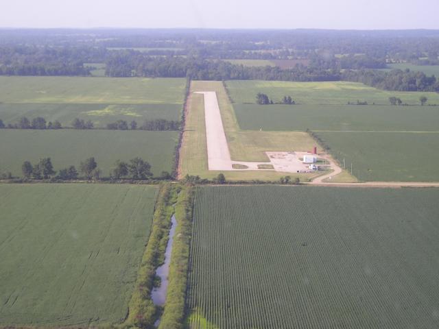
On final for runway 36
(Click on the photo to enlarge) |
Images
and information placed above are from
http://www.airport-data.com/airport/7M8/
http://www.shashek.com/Flight_Logs/images/Airports/Rector_AR/Rector_Airport.shtml
We
thank them for the data!
|
General Info |
| Country |
United
States |
| State |
ARKANSAS
|
| FAA
ID |
7M8
|
| Latitude |
36-15-00.227N
|
| Longitude |
090-19-10.364W
|
| Elevation |
281
feet |
| Near
City |
RECTOR
|
We don't guarantee the information is fresh and accurate. The data may be wrong or outdated.
For more up-to-date information please refer to other sources.
|
|