|
|

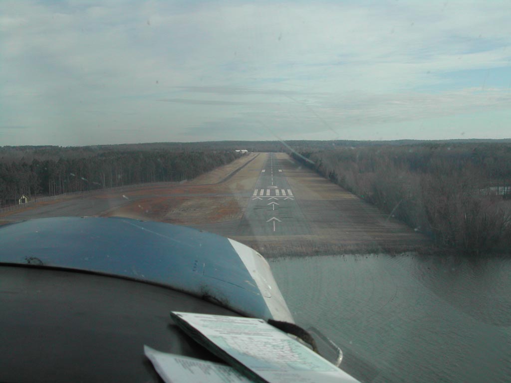
The
park airport offers five Fly-in Premium D campsites (for tents only).
Petit
Jean State Park is Arkansas's only state park that features its
own airport. Petit Jean's airport is open for daytime use only. For information
about the park airport or fly-in campsites, call (501) 727-5441
|
 |
(Click on the photo to
enlarge) |
Location
& QuickFacts
| FAA Information Effective: |
2005-10-27 |
| Airport Identifier: |
MPJ |
| Longitude/Latitude: |
092-54-33.1090W/35-08-19.9070N
-92.909197/35.138863 (Estimated) |
| Elevation: |
923
ft / 281.33 m (Surveyed) |
| Land: |
148
acres |
| From nearest city: |
8
nautical miles W of Morrilton, AR |
| Location: |
Conway
County, AR |
| Magnetic Variation: |
04E
(1985) |
Owner &
Manager
| Ownership: |
Publicly
owned |
| Owner: |
State
Of Arkansas |
| Address: |
One
Capitol Mall
Little Rock, AR 72203 |
| Phone number: |
501-727-5441,
501-682-2535 |
| Manager: |
Marvin
Perry |
| Address: |
571
Winrock
Morrilton, AR 72110 |
| Phone number: |
501-354-6634 |
Airport
Operations and Facilities
| Airport Use: |
Open
to public |
| Wind indicator: |
Yes |
| Segmented Circle: |
No |
| Control Tower: |
No |
| Attendance Schedule: |
ALL/ALL/0800-1700 |
| Landing fee charge: |
No |
| Sectional chart: |
Memphis |
| Region: |
ASW
- Southwest |
| Boundary ARTCC: |
ZME
- Memphis |
| Tie-in FSS: |
JBR
- Jonesboro |
| FSS on Airport: |
No |
| FSS Phone: |
870-935-3471 |
| FSS Toll Free: |
1-800-WX-BRIEF |
| NOTAMs Facility: |
JBR
(NOTAM-d service avaliable) |
| Federal Agreements: |
N1 |
Airport
Communication
Airport
Services
| Airframe Repair: |
MAJOR |
| Power Plant Repair: |
MAJOR |
Runway Information
Runway 03/21
| Dimension: |
5853
x 75 ft / 1784.0 x 22.9 m |
| Surface: |
ASPH,
Good Condition |
| Weight Limit: |
Single
wheel: 17000 lbs. |
| |
Runway
03 |
Runway
21 |
| Longitude: |
092-54-50.1780W |
092-54-15.8260W |
| Latitude: |
35-07-54.5800N |
35-08-45.3970N |
| Elevation: |
889.00
ft |
923.00
ft |
| Alignment: |
29 |
127 |
| Traffic Pattern: |
Left |
Left |
| Markings: |
Non-precision
instrument, Fair Condition |
Basic,
Fair Condition |
| Displaced threshold: |
450.00
ft |
175.00
ft |
| Obstruction: |
95
ft trees, 1530.0 ft from runway, 14:1 slope to clear
APCH RATIO 20:1 FM DSPLCD THLD. |
65
ft trees, 565.0 ft from runway, 5:1 slope to clear
APCH RATIO 11:1 FM DSPLCD THLD. |
|
Radio Navigation
Aids
| ID |
Type |
Name |
Ch |
Freq |
Var |
Dist |
| MPJ |
NDB |
Morrilton |
|
410.00 |
07E |
1.4
nm |
| BDQ |
NDB |
Bridge |
|
208.00 |
04E |
9.7
nm |
| RUE |
NDB |
Russellville |
|
379.00 |
03E |
11.6
nm |
| CWS |
NDB |
Conway |
|
302.00 |
05E |
23.9
nm |
| CZE |
NDB |
Clarksville |
|
201.00 |
04E |
32.1
nm |
| TYV |
NDB |
Toneyville |
|
290.00 |
04E |
45.2
nm |
| HO |
NDB |
Hossy |
|
385.00 |
04E |
45.2
nm |
| MVQ |
NDB |
Malvern |
|
215.00 |
04E |
49.0
nm |
| HBZ |
NDB |
Heber
Springs |
|
256.00 |
03E |
49.5
nm |
|
LRF |
TACAN |
Jacksonville |
029X |
|
04E |
39.3
nm |
| HOT |
VOR/DME |
Hot
Springs |
037X |
110.00 |
04E |
40.7
nm |
|
LIT |
VORTAC |
Little
Rock |
086X |
113.90 |
05E |
45.4
nm |
Remarks
- ULTRALIGHT ACTIVITY ON & INVOF
ARPT
Petit
Jean Park Airport
Address:
Conway County,
AR
Tel: 501-354-6634
Images
and information placed above are from
http://www.airport-data.com/airport/MPJ/
http://www.airstripamerica.com/cgi-bin/apt_info?MPJ
http://www.arkansasstateparks.com/parks/park.asp?id=1
We thank them for the data!
| General Info |
| Country |
United
States |
| State |
ARKANSAS
|
| FAA
ID |
MPJ
|
| Latitude |
35-08-19.907N
|
| Longitude |
092-54-33.109W
|
| Elevation |
923
feet |
| Near
City |
MORRILTON
|
We don't guarantee the information is fresh and accurate. The data may be wrong or outdated.
For more up-to-date information please refer to other sources.
|
|