 |
|
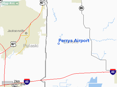
Location
& QuickFacts
|
FAA Information Effective: |
2005-10-27 |
|
Airport Identifier: |
79AR |
|
Longitude/Latitude: |
092-02-53.5180W/34-51-10.3210N
-92.048199/34.852867 (Estimated) |
|
Elevation: |
263
ft / 80.16 m (Estimated) |
|
Land: |
40
acres |
|
From nearest city: |
3
nautical miles SE of Jacksonville, AR |
|
Location: |
Lonoke
County, AR |
|
Magnetic Variation: |
04E
(1985) |
Owner &
Manager
|
Ownership: |
Privately
owned |
|
Owner: |
Fred
H. Perry |
|
Address: |
3027 Cresthaven Ct
Grapevine, TX 76051
Po Box 182
Jacksonville, AR 72076 |
|
Manager: |
Ron
Chidester |
|
Address: |
Lonoke
County, AR |
|
Phone number: |
501-982-2692 |
Airport
Operations and Facilities
|
Airport Use: |
Private |
|
Wind indicator: |
Yes |
|
Segmented Circle: |
No |
|
Control Tower: |
No |
|
Attendance Schedule: |
UNATNDD |
|
Landing fee charge: |
No |
|
Sectional chart: |
Memphis |
|
Region: |
ASW
- Southwest |
|
Boundary ARTCC: |
ZME
- Memphis |
|
Tie-in FSS: |
JBR
- Jonesboro |
|
FSS on Airport: |
No |
|
FSS Phone: |
870-935-3471 |
|
FSS Toll Free: |
1-800-WX-BRIEF |
Airport
Services
|
Airframe Repair: |
MINOR |
|
Power Plant Repair: |
MAJOR |
Runway Information
Runway N/S
|
Dimension: |
2600
x 75 ft / 792.5 x 22.9 m |
|
Surface: |
TURF,
Good Condition |
| |
Runway
N |
Runway
S |
|
Traffic Pattern: |
Left |
Left |
| Obstruction: |
30 ft pline, 20.0 ft from runway, 6:1 slope to clear
20' PLINE 120' SOUTH OF RWY THR. |
40 ft trees, 360.0 ft from runway, 14:1 slope to clear |
|
Radio Navigation
Aids
| ID |
Type |
Name |
Ch |
Freq |
Var |
Dist |
| TYV |
NDB |
Toneyville |
|
290.00 |
04E |
6.2
nm |
|
CWS |
NDB |
Conway |
|
302.00 |
05E |
23.3
nm |
| SGT |
NDB |
Stuttgart |
|
269.00 |
02E |
25.2
nm |
|
SRC |
NDB |
Searcy |
|
323.00 |
02E |
26.6
nm |
| BDQ |
NDB |
Bridge |
|
208.00 |
04E |
37.0
nm |
|
HBZ |
NDB |
Heber
Springs |
|
256.00 |
03E |
39.8
nm |
| BKZ |
NDB |
Brinkley |
|
242.00 |
02E |
43.0
nm |
|
MPJ |
NDB |
Morrilton |
|
410.00 |
07E |
46.0
nm |
| MVQ |
NDB |
Malvern |
|
215.00 |
04E |
47.2
nm |
|
LRF |
TACAN |
Jacksonville |
029X |
|
04E |
6.7
nm |
| PBF |
VOR/DME |
Pine
Bluff |
107X |
116.00 |
04E |
36.9
nm |
|
LIT |
VORTAC |
Little
Rock |
086X |
113.90 |
05E |
12.4
nm |
Perrys Airport
Address:
Lonoke County,
AR
Tel:
501-982-2692
Images and
information placed above are from
http://www.airport-data.com/airport/79AR/
We thank them for the data!
| General Info |
| Country |
United
States |
| State |
ARKANSAS
|
| FAA
ID |
79AR
|
| Latitude |
34-51-10.321N
|
| Longitude |
092-02-53.518W
|
| Elevation |
263
feet |
| Near
City |
JACKSONVILLE
|
We don't guarantee the information is fresh and accurate. The data may be wrong or outdated.
For more up-to-date information please refer to other sources.
|
|


