 |
|
| Ozark Regional Airport |
 |
| IATA: WMH – ICAO: KBPK – FAA LID: BPK |
| Summary |
| Airport type |
Public |
| Owner |
Baxter County |
| Location |
Mountain Home, Arkansas |
| Elevation AMSL |
928 ft / 283 m |
| Coordinates |
36°22′08″N 092°28′14″W / 36.36889°N 92.47056°W / 36.36889; -92.47056 |
| Website |
www.flytheozarks.com |
| Runways |
| Direction |
Length |
Surface |
| ft |
m |
| 5/23 |
5,001 |
1,524 |
Asphalt |
| Statistics (2006) |
| Aircraft operations |
49,500 |
| Based aircraft |
63 |
| Source: Federal Aviation Administration |
Ozark Regional Airport (IATA: WMH, ICAO: KBPK, FAA LID: BPK), formerly known as Baxter County Regional Airport, is a general aviation airport located four miles (6 km) northeast of the central business district of Mountain Home, a city in Baxter County, Arkansas, United States.
Although most U.S. airports use the same three-letter location identifier for the FAA and IATA, Ozark Regional is assigned BPK by the FAA and WMH by the IATA. The airport's ICAO identifier is KBPK.
Facilities and aircraft
Ozark Regional Airport covers an area of 330 acres (134 ha). It has one asphalt paved runway designated 5/23 which measures 5,001 by 75 feet (1,524 x 23 m).
For 12-month period ending May 31, 2006, the airport had 49,500 aircraft operations, an average of 135 per day: 97% general aviation (48,000), 2% military (1,200) and 1% air taxi (300). There are 63 aircraft based at this airport: 71% single engine (45), 27% multi engine (17) and 2% jet aircraft (1).
The above content comes from Wikipedia and is published under free licenses – click here to read more.

Ozark Regional Airport ( formerly Baxter
County Regional Airport )
The airport northwest
of Mountain Home was constructed in 1965 by the local Industrial Development
Corporation of the Ozarks to provide air service for the industrial district,
a 700-acre tract. Funding was private. From 1966 to 1975, the City of
Mountain Home leased the airport, and a private air service leased it
from 1975 to 1979. The Baxter County Airport Authority was formed in 1979
to develop and operate the airport. The name was then changed to and remains
Ozark Regional Airport.
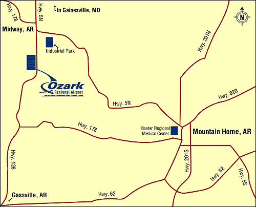
Ozark Regional Airport is
conveniently located 6 miles northwest of Mountain Home near the town
of Midway. The airport features a paved, lighted 5,000-foot runway and
a 6,800 square foot terminal. Many of the area resorts and hotels will
provide free courtesy shuttle service to and from the airport.

Location
& QuickFacts
| FAA
Information Effective: |
2005-10-27 |
| Airport
Identifier: |
BPK |
| Longitude/Latitude: |
092-28-13.9010W/36-22-08.1910N
-92.470528/36.368942 (Estimated) |
| Elevation: |
928
ft / 282.85 m (Surveyed) |
| Land: |
314 acres |
| From
nearest city: |
4
nautical miles NW of Mountain Home, AR |
| Location: |
Baxter County, AR |
| Magnetic
Variation: |
03E
(1995) |
Owner &
Manager
| Ownership: |
Publicly owned |
| Owner: |
Baxter
County |
| Address: |
County
Courthouse, 1 East 7th - Suite 303
Mountain Home, AR 72653 |
| Phone
number: |
870-425-2755 |
| Url: |
http://www.flytheozarks.com/
http://www.mtnhome.net/airport/ |
| Email: |
info@flytheozarks.com
|
| Manager: |
Jack Marchbank |
| Address: |
6462
Hwy. 126 North
Midway, Arkansas |
| Phone
number: |
870-481-5418
FBO PHONE - 870-481-5966 |
| Email: |
BCRA@baxtercounty.net
|
Airport
Operations and Facilities
| Airport
Use: |
Open to public |
| Wind
indicator: |
Yes |
| Segmented
Circle: |
Yes |
| Control
Tower: |
No |
| Attendance
Schedule: |
ALL/ALL/0700-1830 |
| Lighting
Schedule: |
DUSK-DAWN
ACTVT MIRL RY 05/23 & PAPI RYS 05 & 23 - CTAF. |
| Beacon
Color: |
Clear-Green
(lighted land airport) |
| Landing
fee charge: |
No |
| Sectional
chart: |
Kansas City |
| Region: |
ASW
- Southwest |
| Boundary
ARTCC: |
ZME - Memphis |
| Tie-in
FSS: |
JBR
- Jonesboro |
| FSS
on Airport: |
No |
| FSS
Phone: |
870-935-3471 |
| FSS
Toll Free: |
1-800-WX-BRIEF |
| NOTAMs
Facility: |
BPK
(NOTAM-d service avaliable) |
| Federal
Agreements: |
NGY |
Airport
Communications
|
CTAF: |
123.000 |
|
Unicom: |
123.000
|
| WX
ASOS: |
133.975
(870-481-5946) |
| WX
AWOS-3 |
at
FLP (7 nm SW) 132.075 (870-453-2380) |
| |
APCH/DEP
SVC PRVDD By MEMPHIS ARTCC on FREQS 126.85/286.6 (Harrison RCAG) |
Airport
Services
| Fuel
available: |
100LL
JET-A |
|
Airframe Repair: |
MAJOR |
| Power
Plant Repair: |
MAJOR |
Runway
Information
Runway
05/23
| Dimension: |
5001 x
75 ft / 1524.3 x 23 m |
| Surface: |
ASPH, Good Condition |
| Weight Limit: |
Single wheel: 17000 lbs.
|
| Edge
Lights: |
Medium |
| |
Runway 05 |
Runway 23 |
| Longitude: |
092-28-37.9170W |
092-27-49.8820W |
| Latitude: |
36-21-52.8910N |
36-22-23.4890N |
| Elevation: |
928.00 ft |
912.00 ft |
| Alignment: |
52 |
127 |
| Traffic
Pattern: |
Left |
Left |
| Markings: |
Non-precision
instrument, Good Condition |
Non-precision
instrument, Good Condition |
| Crossing
Height: |
41.00 ft |
45.00 ft |
| VASI: |
2-light PAPI
on left side |
2-light PAPI
on left side |
| Visual
Glide Angle: |
3.00° |
4.00° |
| Obstruction: |
18 ft road,
570.0 ft from runway, 20:1 slope to clear
GND GRADUALLY RISES AWAY FM RY APRXLY 3' WITHIN CLOSE-IN AREA. |
55 ft pline,
1300.0 ft from runway, 300 ft right of centerline, 20:1 slope
to clear |
|
Radio Navigation
Aids
|
ID |
Type |
Name |
Ch |
Freq |
Var |
Dist |
| VLX |
NDB |
Wilcox |
|
348.00 |
02E |
35.2 nm |
| AOV |
NDB |
Bilmart |
|
341.00 |
02E |
37.5 nm |
| PLK |
NDB |
Point Lookout/dcmsnd |
|
204.00 |
03E |
39.8 nm |
| UNO |
NDB |
Pomona |
|
335.00 |
02E |
41.1 nm |
| AJX |
NDB |
Ash Flat |
|
344.00 |
03E |
43.4 nm |
| FLP |
VOR/DME |
Flippin |
075X |
112.80 |
03E |
4.2 nm |
| HRO |
VOR/DME |
Harrison |
072X |
112.50 |
04E |
36.1 nm |
| HUW |
VOR/DME |
Hutton |
053X |
111.60 |
02E |
40.9 nm |
| DGD |
VORTAC |
Dogwood |
031X |
109.40 |
06E |
43.9 nm |
Remarks
- Flight school/Flight
training, Aircraft rental, Aerial tours/Aerial sightseeing, Pilot supplies
Ozark Regional Airport
6462 Hwy. 126 North
Midway, Arkansas
Tel (870) 481-5418
E-mail: info@flytheozarks.com
URL: http://www.flytheozarks.com/
Images
and information placed above are from
http://www.flytheozarks.com/
http://www.airport-data.com/airport/BPK/
http://www.mtnhome.net/airport/
We
thank them for the data!
|
General Info |
| Country |
United
States |
| State |
ARKANSAS
|
| FAA
ID |
BPK |
| Latitude |
36.368942
36° 22' 08.19" N |
| Longitude |
-92.470528
092° 28' 13.90" W |
| Elevation |
928
feet
283 meters |
| Near
City |
Mountain
Home |
We don't guarantee the information is fresh and accurate. The data may be wrong or outdated.
For more up-to-date information please refer to other sources.
|
|


