|
|
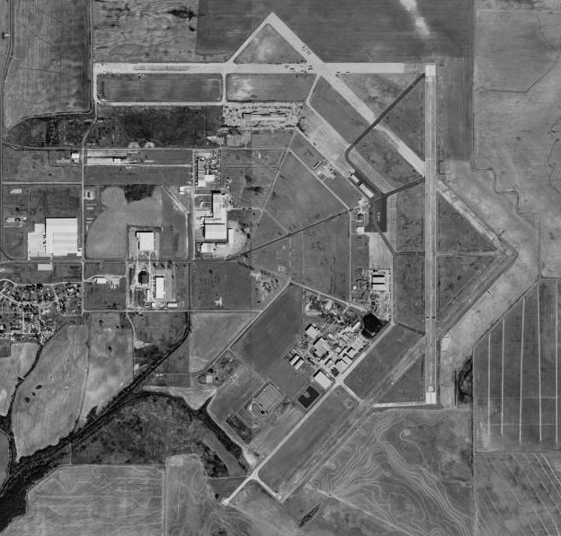
Newport Municipal Airport |
| Newport Municipal Airport |
 |
| USGS aerial photo, 13 February 1994 |
| IATA: none – ICAO: none – FAA LID: M19 |
| Summary |
| Airport type |
Public |
| Owner |
City of Newport |
| Location |
Newport, Arkansas |
| Elevation AMSL |
239 ft / 72 m |
| Coordinates |
35°38′25″N 091°10′50″W / 35.64028°N 91.18056°W / 35.64028; -91.18056 |
| Runways |
| Direction |
Length |
Surface |
| ft |
m |
| 4/22 |
5,000 |
1,524 |
Asphalt |
| 18/36 |
5,000 |
1,524 |
Asphalt |
 | |
Oblique airphoto of Newport Army Airfield, about 1945, looking east to west. |
Newport Municipal Airport (FAA LID: M19) is a general aviation airport located 5 miles NE of Newport, Arkansas.
It is owned and operated by the city of Newport. History
The airport was opened in December 1942 as Newport Army Airfield and was used by the United States Army Air Forces as a training base during World War II which conducted training as part of the 70,000 Pilot Training Program. It was assigned to the AAF Flying Training Command, Southeast Training Center (later Eastern Flying Training Command) as a basic (stage 2) pilot training airfield.
Instruction at the school consisted of teaching the cadets to fly in formation, fly by instruments or by aerial navigation, fly at night, and fly for long distances. Aviation Cadets who washed out of pilot training were usually sent to navigator or bombardier school. The initial aircraft complement numbered 24 Vultee BT-13 Valiant and BT-15 aircraft. The ten-week course consisted of 70 hours of flight training and 150 hours of ground training.
Four thousand Army pilots received basic training at Newport field from Dec. 25, 1942, to June 21, 1944. Some 425,000 hours were flown during the time, with only 20 fatalities. Two known auxiliary airfields, Erwin and Milltown, were used by the flight school at Newport AAF.
USAAF pilot training ended at Newport, and the United States Marine Corps began to utilize the airfield beginning in May 1944. The field was renamed Marine Corps Air Facility Newport and was home to Marine Aircraft Group 34 (MAG-34) and its SBD Dauntless aircraft and Marine Aircraft Group 62 (MAG-62) and its PBJ squadrons. One of Newport's shortcomings was a lack of local bombing and gunnery ranges which at the end of the war led to the Marine Corps deeding the airport to the City of Newport. None of the temporary structures built by the USAAF or USMC remain today. The few that survived the war were destroyed by a tornado in 1953.
The above content comes from Wikipedia and is published under free licenses – click here to read more.

Location & QuickFacts
| FAA
Information Effective: |
2005-10-27 |
|
Airport Identifier: |
M19 |
| Longitude/Latitude: |
091-10-34.9520W/35-38-15.7840N
-91.176376/35.637718 (Estimated) |
|
Elevation: |
239
ft / 72.85 m (Surveyed) |
| Land: |
331 acres |
|
From nearest city: |
5 nautical miles NE of Newport, AR |
| Location: |
Jackson County, AR |
|
Magnetic Variation: |
04E
(1980) |
Owner & Manager
| Ownership: |
Publicly owned |
|
Owner: |
City
Of Newport |
| Address: |
615 3rd St
Newport, AR 72112 |
|
Phone number: |
870-523-6568 |
| Manager: |
Jim Martin |
|
Address: |
8502
Victory Blvd
Newport, AR 72112 |
| Phone
number: |
870-523-3613 |
Airport Operations and Facilities
| Airport
Use: |
Open to public |
|
Wind indicator: |
Yes |
| Segmented
Circle: |
No |
|
Control Tower: |
No |
| Attendance
Schedule: |
ALL/MON-SAT/0800-1700,ALL/SUN/1300-1700 |
|
Lighting Schedule: |
DUSK-DAWN
ACTVT MIRL RY 18/36 - CTAF |
| Beacon
Color: |
Clear-Green
(lighted land airport) |
|
Landing fee charge: |
No |
| Sectional
chart: |
Memphis |
|
Region: |
ASW
- Southwest |
| Traffic
Pattern Alt: |
1000 ft |
|
Boundary ARTCC: |
ZME
- Memphis |
| Tie-in
FSS: |
JBR - Jonesboro |
|
FSS on Airport: |
No |
| FSS
Phone: |
870-935-3471 |
|
FSS Toll Free: |
1-800-WX-BRIEF |
| NOTAMs
Facility: |
JBR
(NOTAM-d service avaliable) |
|
Federal Agreements: |
NGPRY |
Airport
Communications
|
CTAF: |
122.800 |
|
Unicom: |
122.800 |
Airport
Services
| Fuel
available: |
100LLA
24 HR SELF SERVICE FUEL AVBL WITH CREDIT CARD. |
|
Airframe Repair: |
MAJOR |
| Power
Plant Repair: |
MAJOR |
|
Bottled Oxygen: |
NONE |
| Bulk
Oxygen: |
NONE |
Runway Information
Runway 04/22
| Dimension: |
5002
x 150 ft / 1524.6 x 45.7 m |
| Surface: |
CONC, Fair Condition |
| Weight Limit: |
Single wheel: 30000 lbs.
|
| |
Runway 04 |
Runway 22 |
| Longitude: |
091-10-59.4630W |
091-10-17.3630W |
| Latitude: |
35-37-47.8580N |
35-38-23.4410N |
| Elevation: |
235.00
ft |
237.00
ft |
| Alignment: |
44 |
127 |
| Traffic
Pattern: |
Left |
Left |
| Markings: |
Basic,
Poor Condition
RY 04/22 MARKINGS FADED. |
Basic, Poor Condition |
|
Runway 18/36
| Dimension: |
5002
x 150 ft / 1524.6 x 45.7 m |
| Surface: |
CONC, Fair Condition |
| Weight Limit: |
Single wheel: 30000 lbs.
|
| Edge
Lights: |
Medium |
| |
Runway 18 |
Runway 36 |
| Longitude: |
091-10-31.0260W |
091-10-32.1010W |
| Latitude: |
35-38-50.6940N |
35-38-01.2300N |
| Elevation: |
238.00
ft |
239.00
ft |
| Alignment: |
127 |
1 |
| Traffic
Pattern: |
Left |
Left |
| Markings: |
Non-precision
instrument, Fair Condition |
Precision instrument, Fair
Condition |
| Crossing
Height: |
42.00
ft |
31.00
ft |
| VASI: |
4-light
PAPI on left side |
4-light
PAPI on left side |
| Visual
Glide Angle: |
3.00° |
3.00° |
| Runway
End Identifier: |
Yes |
Yes |
| Obstruction: |
32
ft pline, 1740.0 ft from runway, 48:1 slope to clear |
, 50:1
slope to clear |
|
Radio Navigation Aids
|
ID |
Type |
Name |
Ch |
Freq |
Var |
Dist |
| EWP |
NDB |
Newport |
|
400.00 |
04E |
0.3 nm |
|
INY |
NDB |
Independence
County |
|
317.00 |
03E |
30.3 nm |
| TNZ |
NDB |
Lawrence County |
|
227.00 |
01E |
36.3 nm |
|
SRC |
NDB |
Searcy |
|
323.00 |
02E |
37.4 nm |
| AJX |
NDB |
Ash Flat |
|
344.00 |
03E |
38.8 nm |
|
PGR |
NDB |
Paragould |
|
383.00 |
01E |
41.3 nm |
| HBZ |
NDB |
Heber Springs |
|
256.00 |
03E |
41.5 nm |
|
BKZ |
NDB |
Brinkley |
|
242.00 |
02E |
45.5 nm |
| FCY |
NDB |
Forrest City |
|
332.00 |
01E |
46.3 nm |
|
VLX |
NDB |
Wilcox |
|
348.00 |
02E |
46.9 nm |
| JBR |
VOR/DME |
Jonesboro |
023X |
108.60 |
02E |
32.0 nm |
|
GQE |
VOR/DME |
Gilmore |
077X |
113.00 |
04E |
38.4 nm |
| ARG |
VORTAC |
Walnut Ridge |
092X |
114.50 |
04E |
30.4 nm |
Remarks
- NUMEROUS AGRICULTURAL OPNS YEAR ROUND.
- PRE DATES THE ACT.
Newport Municipal Airport
Address: Jackson County, AR
Tel: 870-523-3613
Images and information placed above are from
http://www.airport-data.com/airport/M19/
We
thank them for the data!
|
General Info |
| Country |
United
States |
| State |
ARKANSAS
|
| FAA
ID |
M19
|
| Latitude |
35-38-15.784N
|
| Longitude |
091-10-34.952W
|
| Elevation |
239
feet |
| Near
City |
NEWPORT
|
We don't guarantee the information is fresh and accurate. The data may be wrong or outdated.
For more up-to-date information please refer to other sources.
|
|