|
 |
|
||||
|
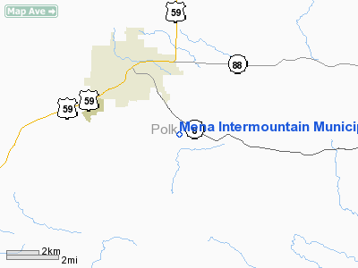
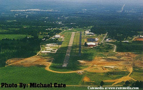
Mena Intermountain Municipal Airport (ICAO: KMEZ, FAA LID: MEZ) is a public airport located two miles (3 km) southeast of the central business district of Mena, a city in Polk County, Arkansas, United States. It is owned by City of Mena. Although most U.S. airports use the same three-letter location identifier for the FAA and IATA, Mena Intermountain Municipal Airport is assigned MEZ by the FAA but has no designation from the IATA (which assigned MEZ to Messina, South Africa). Facilities and aircraftMena Intermountain Municipal Airport covers an area of 556 acres (225 ha) which contains two asphalt paved runways: Runway 9/27 measuring 6,000 x 100 ft (1,829 x 30 m), and Runway 17/35 measuring 5,000 x 75 ft (1,524 x 23 m). For the 12-month period ending November 30, 2005, the airport had 27,500 aircraft operations, an average of 75 per day: 91% general aviation, 7% air taxi and 2% military. There are 53 aircraft based at this airport: 64% single engine, 28% multi-engine and 8% jet aircraft. Allegations regarding Bill ClintonDuring the Clinton presidential administration, there were accusations (most notably in the controversial film Clinton Chronicles) that Clinton, during his time as governor of Arkansas, and other high-ranking state officials were involved in some way with alleged illegal cocaine importation, money laundering, and drug use centered upon the airport in Mena.[1] These allegations have been disputed by several different investigations, including one by the Banking Committee of the U.S. House of Representatives. [2]. Iran ContraMena was home to "Operation Black Eagle" of the Iran-Contra affair. The above content comes from Wikipedia and is published under free licenses – click here to read more.
The Intermountain Municipal Airport in Mena, Arkansas provides complete and quality aircraft services.Whether you are in need of aircraft painting services, engine repair or rebuilding, airframe repair, upholstery, or avionics repair, your are at the right spot. Located in the Geographical Center of the United States, Mena is a unique setting to server all of the U.S. and more. Mena's Intermountain Municipal Airport is your one-stop-facility to provide all your aircraft repair, painting, upholstery, maintenance and modifications needs. History of the Mena Intermountain Municipal Airport An airport at Mena was the dream of interested pilots and hobby flyers in the 1930's. A rough flying field was started on the McBride property south of town in the early 40's. In 1942, Hartzell Geyer built the first hangar and opened a small flying school. In 1946 serious construction was begun as the Civil Aeronautics Commission ( now the FAA) chose the site as an emergency landing strip for commercial aircraft. Mayor Albert Middleton requested the property under Eminent Domain from the McBride estate. Mena is the approximate midway point between Fort Smith and Texarkana and was a desirable point being approximately 100 miles from the nearest airport. In the early years the grass field was maintained by an agreement with a farmer who mowed and bailed the runway for the hay. The portraits of two flight pioneers now hang at the airport office honoring the contributions of Hamp Edwards, an early flight instructor and Leo Overturf, an early airport businessman and pilot that was killed in a crash in the early 1970's. After development of the airstrip, several businesses began to service aircraft at the remote but centrally located airport. Popularity of the airport has continued to grow through the years. Presently the Regional Airport has a lighted and paved 5000 foot runway with support and mechanical services for most aircraft including small and mid-sized commercial airliners. The aircraft industry at Mena now employs more than 160 in upholstery, painting, engineering and general maintenance fields. The Mena Aircraft industry brings millions of dollars into the local economy each year. A second landing strip is now under construction and will be equipped for instrument landing. The new 6000 foot runway is a result of the progressive efforts of local business leaders. This addition will be a boost to the local economy for many years to come.
Mena Intermountain Municipal Airport Address: Tel: 479-394-4077 E-mail: mima@cswnet.com URL: http://www.menaairport.com/ Location & QuickFacts
Owner & Manager
Airport Operations and Facilities
Airport Communication
Airport Services
Runway InformationRunway 09/27
Runway 17/35
Radio Navigation Aids
Remarks
Images and information placed above are from
http://www.menaairport.com/
We don't guarantee the information is fresh and accurate. The data may be wrong or outdated. For more up-to-date information please refer to other sources. |
|||||||||||||||||||||||||||||||||||||||||||||||||||||||||||||||||||||||||||||||||||||||||||||||||||||||||||||||||||||||||||||||||||||||||||||||||||||||||||||||||||||||||||||||||||||||||||||||||||||||||||||||||||||||||||||||||||||||||||||||||||||||||||||||||||||||||||||||||||||||||||||||||||||||||||||||||||||||||||||||||||||

 |
|
Copyright 2004-2026 © by Airports-Worldwide.com, Vyshenskoho st. 36, Lviv 79010, Ukraine Legal Disclaimer |