 |
|
Location
& QuickFacts
| FAA
Information Effective: |
2005-10-27 |
|
Airport Identifier: |
AR36 |
| Longitude/Latitude: |
094-08-00.7330W/36-20-00.2710N
-94.133537/36.333409 (Estimated) |
|
Elevation: |
1350
ft / 411.48 m (Estimated) |
| Land: |
0 acres |
|
From nearest city: |
0
nautical miles W of Rogers, AR |
| Location: |
Benton
County, AR |
|
Magnetic Variation: |
05E
(1985) |
Owner
& Manager
|
Ownership: |
Privately
owned |
|
Owner: |
St
Mary-rogers Meml Hospital |
|
Address: |
1200
W Walnut Street
Rogers, AR 72756-3599 |
|
Phone number: |
501-636-0200 |
|
Manager: |
President |
|
Address: |
1200
W Walnut Street
Rogers, AR 72756-3599 |
|
Phone number: |
501-636-0200 |
Airport
Operations and Facilities
|
Airport Use: |
Private
MEDICAL. |
|
Wind indicator: |
No |
|
Segmented Circle: |
No |
|
Control Tower: |
No |
|
Attendance Schedule: |
ALL/ALL/ALL |
|
Lighting Schedule: |
PHONE
REQ
FOR PERIMETER LGTS CALL 501-636-0200. |
|
Landing fee charge: |
No |
|
Sectional chart: |
Kansas
City |
|
Region: |
ASW
- Southwest |
|
Boundary ARTCC: |
ZME
- Memphis |
|
Tie-in FSS: |
JBR
- Jonesboro |
| FSS
on Airport: |
No |
|
FSS Phone: |
870-935-3471 |
| FSS
Toll Free: |
1-800-WX-BRIEF |
Runway
Information
Helipad
H1
| Dimension: |
60 x 60
ft / 18.3 x 18.3 m |
| Surface: |
ASPH,
|
|
|
Runway
H1 |
Runway
|
|
Traffic Pattern: |
Left |
Left |
|
Radio
Navigation Aids
|
ID |
Type |
Name |
Ch |
Freq |
Var |
Dist |
| SLG |
NDB |
Siloam Springs |
|
284.00 |
04E |
19.3 nm |
|
PLK |
NDB |
Point
Lookout/dcmsnd |
|
204.00 |
03E |
47.1
nm |
| TQH |
NDB |
Tahlequah |
|
215.00 |
05E |
48.9 nm |
|
DAK |
VOR/DME |
Drake |
025X |
108.80 |
07E |
17.7
nm |
| EOS |
VOR/DME |
Neosho |
120X |
117.30 |
07E |
33.9 nm |
|
HRO |
VOR/DME |
Harrison |
072X |
112.50 |
04E |
44.6
nm |
| RZC |
VORTAC |
Razorback |
111X |
116.40 |
04E |
5.3 nm |
Remarks
- CONDL--PROVIDED
INGRESS/EGRESS ROUTES ARE NOT PLANNED FROM/TO THE EAST, SE OR WEST.
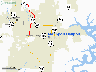
Medi-port Heliport
Address: Benton County,
AR
Tel: 501-636-0200
|
General Info |
| Country |
United
States |
| State |
ARKANSAS
|
| FAA
ID |
AR36
|
| Latitude |
36-20-00.271N
|
| Longitude |
094-08-00.733W
|
| Elevation |
1350
feet |
| Near
City |
ROGERS
|
We don't guarantee the information is fresh and accurate. The data may be wrong or outdated.
For more up-to-date information please refer to other sources.
|
|


