 |
|
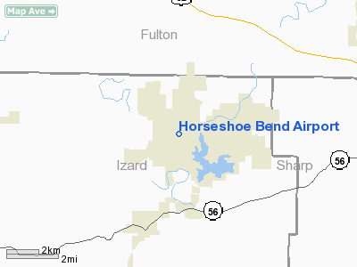
Location
& QuickFacts
|
FAA Information Effective: |
2005-10-27 |
|
Airport Identifier: |
6M2 |
|
Longitude/Latitude: |
091-45-19.7400W/36-13-16.9300N
-91.755483/36.221369 (Estimated) |
|
Elevation: |
782
ft / 238.35 m (Estimated) |
|
Land: |
35
acres |
|
From nearest city: |
1
nautical miles NE of Horseshoe Bend, AR |
|
Location: |
Izard
County, AR |
|
Magnetic Variation: |
03E
(1985) |
Owner &
Manager
|
Ownership: |
Publicly
owned |
|
Owner: |
City
Of Horsehoe Bend |
|
Address: |
City
Hall - 704 W Commerce
Horseshoe Bend, AR 72512 |
|
Phone number: |
870-670-5113 |
|
Manager: |
Airport
Commission
ECHLEY SCHATZMAN, CHAIRMAN, 870-670-5229. |
|
Address: |
704
W Commerce
Horseshoe Bend, AR 72512 |
|
Phone number: |
870-670-5113 |
Airport
Operations and Facilities
|
Airport Use: |
Open
to public |
|
Wind indicator: |
Yes |
|
Segmented Circle: |
No |
|
Control Tower: |
No |
|
Attendance Schedule: |
UNATNDD |
|
Lighting Schedule: |
DUSK-DAWN
ACTVT MIRL RY 13/31 - CTAF. |
|
Beacon Color: |
Clear-Green
(lighted land airport) |
|
Landing fee charge: |
No |
|
Sectional chart: |
Kansas
City |
|
Region: |
ASW
- Southwest |
|
Boundary ARTCC: |
ZME
- Memphis |
|
Tie-in FSS: |
JBR
- Jonesboro |
|
FSS on Airport: |
No |
|
FSS Phone: |
870-935-3471 |
|
FSS Toll Free: |
1-800-WX-BRIEF |
|
NOTAMs Facility: |
JBR
(NOTAM-d service avaliable) |
|
Federal Agreements: |
N |
Airport
Communications
|
CTAF: |
122.800 |
|
Unicom: |
122.800
|
Airport
Services
|
Fuel available: |
100LL
FOR FUEL DALGT HRS CALL 870-670-4569. FOR FUEL AFT DARK CTC LCL
POLICE 4 BLOCKS WEST OF ARPT- NO FEE. |
|
Airframe Repair: |
MAJOR |
|
Power Plant Repair: |
MAJOR |
Runway
Information
Runway
13/31
|
Dimension: |
4524
x 50 ft / 1378.9 x 15.2 m |
|
Surface: |
ASPH,
Good Condition |
|
Weight Limit: |
Single
wheel: 4000 lbs. |
|
Edge Lights: |
Medium |
| |
Runway 13 |
Runway 31 |
|
Longitude: |
091-45-42.2300W |
091-44-57.2300W |
|
Latitude: |
36-13-29.8900N |
36-13-03.9500N |
|
Elevation: |
782.00
ft |
778.00
ft |
|
Alignment: |
125 |
127 |
|
Traffic Pattern: |
Left |
Left |
|
Markings: |
Basic,
Good Condition |
Basic,
Good Condition |
|
Crossing Height: |
0.00
ft |
39.00
ft |
|
Displaced threshold: |
500.00
ft |
0.00
ft |
|
VASI: |
|
2-light PAPI on left side |
|
Visual Glide Angle: |
0.00° |
3.00° |
|
Obstruction: |
80 ft trees, 1120.0 ft from runway, 11:1 slope to clear
APCH RATIO 20:1 FM DSPLCD THLD.
TERRAIN RISES 681 FT BTN 200-1100 FT FM END OF RY. |
, 50:1 slope to clear |
|
Radio Navigation
Aids
| ID |
Type |
Name |
Ch |
Freq |
Var |
Dist |
|
AJX |
NDB |
Ash
Flat |
|
344.00 |
03E |
7.6
nm |
|
VLX |
NDB |
Wilcox |
|
348.00 |
02E |
26.9
nm |
|
INY |
NDB |
Independence
County |
|
317.00 |
03E |
31.0
nm |
|
UNO |
NDB |
Pomona |
|
335.00 |
02E |
40.1
nm |
|
TNZ |
NDB |
Lawrence
County |
|
227.00 |
01E |
40.4
nm |
|
HBZ |
NDB |
Heber
Springs |
|
256.00 |
03E |
44.3
nm |
|
EWP |
NDB |
Newport |
|
400.00 |
04E |
44.7
nm |
|
MNF |
NDB |
Mountain
View |
|
365.00 |
03E |
46.5
nm |
|
FLP |
VOR/DME |
Flippin |
075X |
112.80 |
03E |
34.4
nm |
|
HUW |
VOR/DME |
Hutton |
053X |
111.60 |
02E |
39.7
nm |
|
ARG |
VORTAC |
Walnut
Ridge |
092X |
114.50 |
04E |
39.5
nm |
Remarks
- RAPIDLY RISING TERRAIN
WITH TREES ON FINAL APCH RY 13.
- RECOMMEND TKOF RY 13
DUE TO RAPIDLY RISING TERRAIN NW OF ARPT.
- DEER ON & INVOF ARPT.
Horseshoe Bend Airport
Address:
Izard County, AR
Tel: 870-670-5113
Images and information placed
above are from
http://www.airport-data.com/airport/6M2/
We
thank them for the data!
|
General Info |
| Country |
United
States |
| State |
ARKANSAS
|
| FAA
ID |
6M2
|
| Latitude |
36-13-00.242N
|
| Longitude |
091-45-00.524W
|
| Elevation |
770
feet |
| Near
City |
HORSESHOE
BEND |
We don't guarantee the information is fresh and accurate. The data may be wrong or outdated.
For more up-to-date information please refer to other sources.
|
|


