 |
|

 |
http://www.airstripamerica.com/cgi-bin/apt_info?2A2 |
Location
& QuickFacts
|
FAA Information Effective: |
2005-10-27 |
|
Airport Identifier: |
2A2 |
|
Longitude/Latitude: |
092-24-13.7266W/35-39-02.5885N
-92.403813/35.650719 (Estimated) |
|
Elevation: |
1269
ft / 386.79 m (Surveyed) |
|
Land: |
506
acres |
|
From nearest city: |
5
nautical miles NE of Clinton, AR |
|
Location: |
Van
Buren County, AR |
|
Magnetic Variation: |
02E
(2000) |
Owner &
Manager
|
Ownership: |
Privately
owned |
|
Owner: |
Holley
Mountain Properties Inc |
|
Address: |
298
Northridge Rd.
Clinton, AR 72031 |
|
Phone number: |
501-745-5487 |
|
Manager: |
Jim
D. Collom |
|
Address: |
298
Northridge Rd.
Clinton, AR 72031 |
|
Phone number: |
501-745-8700 |
Airport
Operations and Facilities
|
Airport Use: |
Private |
|
Wind indicator: |
Yes |
|
Segmented Circle: |
No |
|
Control Tower: |
No |
|
Attendance Schedule: |
ALL/MON-FRI/0800-1700 |
|
Lighting Schedule: |
DUSK-2000
ACTVT MIRL RY 05/23, REIL RYS 05 & 23 - CTAF. |
|
Beacon Color: |
Clear-Green
(lighted land airport) |
|
Sectional chart: |
Memphis |
|
Region: |
ASW
- Southwest |
|
Boundary ARTCC: |
ZME
- Memphis |
|
Tie-in FSS: |
JBR
- Jonesboro |
|
FSS Phone: |
870-935-3471 |
|
FSS Toll Free: |
1-800-WX-BRIEF |
|
NOTAMs Facility: |
JBR
(NOTAM-d service avaliable) |
Airport
Communication
| CTAF: |
122.700 |
| Unicom: |
122.700 |
Airport
Services
|
Airframe Repair: |
MAJOR |
|
Power Plant Repair: |
MAJOR |
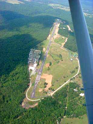
Runway Information
Runway 05/23
|
Dimension: |
4795
x 50 ft / 1461.5 x 15.2 m |
|
Surface: |
ASPH,
Good Condition |
|
Edge Lights: |
Medium |
| |
Runway
05 |
Runway
23 |
|
Longitude: |
092-24-38.0458W |
092-23-49.4052W |
|
Latitude: |
35-38-49.6151N |
35-39-15.5606N |
|
Elevation: |
1270.00
ft |
1270.00
ft |
|
Alignment: |
57 |
127 |
|
Traffic Pattern: |
Left |
Right |
|
Markings: |
Non-precision instrument, Good Condition |
Non-precision instrument, Good Condition |
|
Crossing Height: |
0.00
ft |
40.00
ft |
|
Displaced threshold: |
398.00
ft |
0.00
ft |
|
VASI: |
|
2-light PAPI on left side |
|
Visual Glide Angle: |
0.00° |
3.00° |
|
Runway End Identifier: |
Yes |
Yes |
|
Obstruction: |
15 ft trees, 560.0 ft from runway, 24:1 slope to clear
APCH SLOPE 50:1 TO DSPLCD THLD. |
, 50:1 slope to clear |
|
Helipad
H1
|
Dimension: |
40
x 40 ft / 12.2 x 12.2 m |
|
Surface: |
CONC,
Good Condition |
| |
Runway
H1 |
Runway
|
| Traffic Pattern: |
Left |
Left |
|
Radio Navigation
Aids
| ID |
Type |
Name |
Ch |
Freq |
Var |
Dist |
|
VLX |
NDB |
Wilcox |
|
348.00 |
02E |
19.9
nm |
|
HBZ |
NDB |
Heber
Springs |
|
256.00 |
03E |
20.9
nm |
|
INY |
NDB |
Independence
County |
|
317.00 |
03E |
30.1
nm |
|
CWS |
NDB |
Conway |
|
302.00 |
05E |
34.1
nm |
|
BDQ |
NDB |
Bridge |
|
208.00 |
04E |
34.3
nm |
|
MPJ |
NDB |
Morrilton |
|
410.00 |
07E |
40.9
nm |
|
RUE |
NDB |
Russellville |
|
379.00 |
03E |
41.3
nm |
|
SRC |
NDB |
Searcy |
|
323.00 |
02E |
42.1
nm |
|
TYV |
NDB |
Toneyville |
|
290.00 |
04E |
46.0
nm |
|
LRF |
TACAN |
Jacksonville |
029X |
|
04E |
45.7
nm |
|
FLP |
VOR/DME |
Flippin |
075X |
112.80 |
03E |
39.1
nm |
Remarks
- DEER ON & INVOF RY.
- RY H1 INGRESS TO NW;
EGRESS TO SE.
- PAEW ADJ TO RY.
- PAEW AER 05.
Holley Mountain Airpark
Address:
Van Buren County, AR
Tel:
501-745-8700
 |
http://www.airstripamerica.com/cgi-bin/apt_info?2A2 |
Images and information placed above are from
http://www.airport-data.com/airport/2A2/
http://www.airstripamerica.com/cgi-bin/apt_info?2A2
We
thank them for the data!
| General Info |
| Country |
United
States |
| State |
ARKANSAS
|
| FAA
ID |
2A2
|
| Latitude |
35-39-05.000N
|
| Longitude |
092-24-24.000W
|
| Elevation |
1270
feet |
| Near
City |
CLINTON
|
We don't guarantee the information is fresh and accurate. The data may be wrong or outdated.
For more up-to-date information please refer to other sources.
|
|


