 |
|
Fort Smith Regional Airport |
| Fort Smith Regional Airport |
| IATA: FSM – ICAO: KFSM |
| Summary |
| Airport type |
Public |
| Operator |
Fort Smith Airport Commission |
| Location |
Fort Smith, Arkansas |
| Elevation AMSL |
469 ft / 143 m |
| Coordinates |
35°20′12″N 94°22′03″W / 35.33667°N 94.3675°W / 35.33667; -94.3675Coordinates: 35°20′12″N 94°22′03″W / 35.33667°N 94.3675°W / 35.33667; -94.3675 |
| Runways |
| Direction |
Length |
Surface |
| ft |
m |
| 7/25 |
8,000 |
2,438 |
Asphalt |
| 1/19 |
5,002 |
1,525 |
Asphalt |
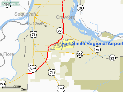
Fort Smith Regional Airport (IATA: FSM, ICAO: KFSM) is a joint civil-military public airport located three miles (5 km) southeast of the central business district (CBD) of Fort Smith, a city in Sebastian County, Arkansas, USA. FSM is mostly used for military aviation for Fort Chaffee and the 188th Fighter Wing (188 FW) of the Arkansas Air National Guard, but is also served by two commercial airlines: Northwest Airlink, (Mesaba Aviation and Pinnacle Airlines) and American Eagle. Most commercial airline traffic in the region originates out of Tulsa International Airport (TUL), 120 miles (190 km) northwest of Fort Smith, as well as Northwest Arkansas Regional Airport (XNA) in Highfill, Arkansas, approximately 85 miles (137 km) driving distance north of Fort Smith. Airlines
| Airlines |
Destinations |
| American Eagle |
Dallas/Fort Worth |
| Delta Connection operated by Mesaba Airlines and Pinnacle Airlines |
Memphis |
(The airport had flights non-stop to Atlanta, GA until 2009 by Atlantic/Southeast Airlines/Delta Connection.)
Military facilities
Since 1953, FSM has been home to Fort Smith Air National Guard Station and the 188th Fighter Wing (188 FW), an Air Combat Command (ACC)-gained unit of the Arkansas Air National Guard. The wing currently flies the A-10 Thunderbolt II aircraft. The 188 FW occupies 3 administrative, 46 industrial, and 3 services buildings at FSM totaling approximately 332,102 square feet (30,853.3 m) with 320 full-time personnel, primarily Air Force Active Guard and Reserve (AGR) and Air Reserve Technician (ART) personnel. Approximately 700 additional traditional part-time Air National Guard personnel are also assigned to the 188 FW.
The above content comes from Wikipedia and is published under free licenses – click here to read more.
About the Airport
Fort Smith Regional Airport, the region's newest passenger terminal,
is also your most convenient. Why wait in traffic? Why wait in long lines?
Why wait? Simply fly Fort Smith.
Mission Statement
As the "Airport of Choice", the Fort Smith Regional Airport
will be self-sustaining, exceed the expectations of quality service, and
meet the air transportation and economic development needs of our customers
and partners.
Vision
To be the Airport of Choice
Supported by Dedicated People and Great
Facilities and Service
Fort Smith Regional Airport Master Plan
Fort Smith is currently updating the Airport's Master
Plan. The project kicked off in May 2005 and will continue for approximately
12 months.
Military Use
The Fort Smith Regional Airport is proud
home of the Arkansas Air National Guard 188th Fighter
Wing. The wing currently operates F-16 aircraft with plans to convert
to A-10 aircraft in 2007 as a part of the 2005 Base Realignment and Closure
action. Information about their operation can be found at www.arftsm.ang.af.mil/html/index1.htm.
The airport also supports training activity from other
military units most notably the 314th Airlift Wing located at Little Rock
Air Force Base (Jacksonville, AR). The base supports the only C-130 training
function in the Department of Defense. Further information is available
at www.littlerock.af.mil.
History
Historical Highlights of the Fort Smith Regional Airport
from 1936 - 2004
1936:
The idea of a municipal airport was established, thus the beginning of
the Fort Smith Municipal Airport. An Airport Advisory Committee was appointed
and the Fort Smith Board of Directors purchased 320 acres with bond money.
1939:
Two sod runways, each measuring 3,500 length and 100 wide were built.
. . . . .
1999:
The vision of the new passenger terminal complex started to become a reality
when a 10 acre ramp was constructed at the site of the new terminal complex.
2001:
An airfield perimeter road was construction to enhance safety of the airfield
by allowing vehicle operations to be segregated from aircraft operations.
2002:
The new terminal complex was completed, and opened for airline service
September 29, 2002. The new terminal complex was completed at an approximate
cost of $12.8 million. The terminal complex includes the passenger terminal
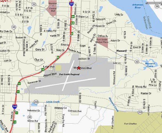
building and related parking lots. A new access road, McKennon Boulevard,
to the terminal complex was constructed by the City of Fort Smith, with
50% Federal funding. The passenger terminal building reflects the traditional
architectural heritage of Fort Smith while maintaining modern airport
geometry and design efficiency. The new terminal was designed to meet
current and future air traffic needs. This 52,200 square feet facility
houses the airlines, rental cars, and a restaurant, the Landing Café,
as well as, offices for Transportation Security Administration (TSA),
and the Airport Administration.
2005:
On February 17, 2005 the new passenger jet bridges were opened to the
public. The jet bridges provide passengers with protection from the weather
between the terminal building and the aircraft. Today the Fort Smith Regional
Airport is a vital transportation venue for the River Valley and plays
a strong role in the continued economic development of the City. As the
community moves forward, the airport's outlook for the future is a very
bright one, filled with continuous growth.
Location
& QuickFacts
| FAA
Information Effective: |
2005-10-27 |
| Airport
Identifier: |
FSM |
| Longitude/Latitude: |
094-22-02.8000W/35-20-11.7000N
-94.367444/35.336583 (Estimated) |
| Elevation: |
469
ft / 142.95 m (Surveyed) |
| Land: |
1359
acres |
| From
nearest city: |
3
nautical miles SE of Fort Smith, AR |
| Location: |
Sebastian
County, AR |
| Magnetic
Variation: |
05E
(1990) |
Owner &
Manager
| Ownership: |
Publicly
owned |
| Owner: |
Fort
Smith Arpt Commission |
| Address: |
6700
Mckennon Blvd Suite 200
Fort Smith, AR 72903 |
| Phone
number: |
479-452-7000 |
| URL: |
http://www.fortsmithairport.com/ |
| Address: |
6700
Mc Kennon Blvd Suite 200
Fort Smith, AR 72903 |
| Phone
number: |
479-452-7000 |
| E-mail: |
admin@fortsmithairport.com |
Airport
Operations and Facilities
| Airport
Use: |
Open
to public |
| Wind
indicator: |
Yes |
| Segmented
Circle: |
Yes |
| Control
Tower: |
Yes |
| Attendance
Schedule: |
ALL/ALL/ALL |
| Lighting
Schedule: |
DUSK-DAWN
WHEN ATCT CLSD ACTVT HIRL RY 07/25; MIRL RY 01/19; MALSR RYS 07
& 25 - CTAF. |
| Beacon
Color: |
Clear-Green
(lighted land airport) |
| Landing
fee charge: |
No |
| Sectional
chart: |
Memphis |
| Region: |
ASW
- Southwest |
| Boundary
ARTCC: |
ZME
- Memphis |
| Tie-in
FSS: |
JBR
- Jonesboro |
| FSS
on Airport: |
No |
| FSS
Phone: |
870-935-3471 |
| FSS
Toll Free: |
1-800-WX-BRIEF |
| NOTAMs
Facility: |
FSM
(NOTAM-d service avaliable) |
| Certification
type/date: |
AS
5/1973
24 HRS PPR FOR UNSKED ACR OPNS WITH MORE THAN 30 PSGR SEATS CALL
AMGR 479-452-7000. |
| Federal
Agreements: |
NGY |
Airport
Communications
| CTAF: |
118.300 |
| Unicom: |
122.950
|
Airport
Services
| Fuel
available: |
100LLA |
| Airframe
Repair: |
MAJOR |
| Power
Plant Repair: |
MAJOR |
| Bottled
Oxygen: |
NONE |
| Bulk
Oxygen: |
NONE |
Runway
Information
Runway
01/19
| Dimension: |
5002
x 150 ft / 1524.6 x 45.7 m |
| Surface: |
ASPH,
Good Condition |
| Surface
Treatment: |
Saw-cut
or plastic Grooved |
| Weight
Limit: |
Single
wheel: 55000 lbs.
Dual wheel: 70000 lbs.
Dual tandem wheel: 120000 lbs. |
| Edge
Lights: |
Medium |
| |
Runway
01 |
Runway
19 |
| Longitude: |
094-22-09.5012W |
094-21-47.7026W |
| Latitude: |
35-19-56.1272N |
35-20-42.2592N |
| Elevation: |
449.00
ft |
447.00
ft |
| Alignment: |
21 |
127 |
| Traffic
Pattern: |
Left |
Left |
| Markings: |
Non-precision
instrument, Good Condition |
Non-precision
instrument, Good Condition |
| Crossing
Height: |
0.00
ft |
40.00
ft |
| VASI: |
|
4-light
PAPI on left side |
| Visual
Glide Angle: |
0.00° |
3.00° |
| Obstruction: |
21
ft rr, 640.0 ft from runway, 313 ft right of centerline, 20:1
slope to clear |
56
ft tree, 1495.0 ft from runway, 365 ft right of centerline,
23:1 slope to clear |
| Decleard
distances: |
Take
off run available 5002.00 ft
Take off distance available 5002.00 ft
Actual stop distance available 5002.00 ft
Landing distance available 5002.00 ft |
Take
off run available 5002.00 ft
Take off distance available 5002.00 ft
Actual stop distance available 5002.00 ft
Landing distance available 5002.00 ft |
|
Runway
07/25
| Dimension: |
8000
x 150 ft / 2438.4 x 45.7 m |
| Surface: |
ASPH,
Good Condition |
| Surface
Treatment: |
Saw-cut
or plastic Grooved |
| Weight
Limit: |
Single
wheel: 75000 lbs.
Dual wheel: 175000 lbs.
Dual tandem wheel: 295000 lbs. |
| Edge
Lights: |
High |
| |
Runway
07 |
Runway
25 |
| Longitude: |
094-22-53.1316W |
094-21-17.7128W |
| Latitude: |
35-20-00.9873N |
35-20-13.0962N |
| Elevation: |
469.00
ft |
444.00
ft |
| Alignment: |
81 |
127 |
| ILS
Type: |
ILS
|
ILS
|
| Traffic
Pattern: |
Left |
Left |
| Markings: |
Precision
instrument, Good Condition |
Precision
instrument, Good Condition |
| Arresting: |
BAK14 |
BAK14 |
| Crossing
Height: |
0.00
ft |
60.00
ft |
| VASI: |
|
4-box on left
side |
| Visual
Glide Angle: |
0.00° |
2.90° |
| RVR
Equipment: |
|
touchdown |
| Approach
lights: |
MALSR |
MALSR |
| Obstruction: |
78
ft tree, 2102.0 ft from runway, 692 ft left of centerline,
24:1 slope to clear |
100
ft tree, 3910.0 ft from runway, 1032 ft right of centerline,
37:1 slope to clear |
| Decleard
distances: |
Take
off run available 8000.00 ft
Take off distance available 8000.00 ft
Actual stop distance available 8000.00 ft
Landing distance available 8000.00 ft |
Take
off run available 8000.00 ft
Take off distance available 8000.00 ft
Actual stop distance available 8000.00 ft
Landing distance available 8000.00 ft |
|
Radio Navigation
Aids
| ID |
Type |
Name |
Ch |
Freq |
Var |
Dist |
| IQS |
NDB |
Sallisaw |
|
520.00 |
05E |
21.3
nm |
|
CZE |
NDB |
Clarksville |
|
201.00 |
04E |
46.9
nm |
| TQH |
NDB |
Tahlequah |
|
215.00 |
05E |
47.2
nm |
|
MKO |
NDB |
Muskogee |
|
306.00 |
06E |
47.6
nm |
| MEZ |
NDB |
Mena |
|
242.00 |
04E |
48.0
nm |
|
DAK |
VOR/DME |
Drake |
025X |
108.80 |
07E |
43.3
nm |
| FSM |
VORTAC |
Fort
Smith |
041X |
110.40 |
07E |
5.6
nm |
|
PGO |
VORTAC |
Rich
Mountain |
082X |
113.50 |
04E |
41.2
nm |
Remarks
- RY 01
AIMING POINTS 1390 FT FM THLD.
- ACFT
TRNG PROHIBITED ON RY 01/19 (INCLG PRACTICE APCH; TGL & INSTR APCH)
BTN 1900-0900 MON-SAT DUE TO NOISE SENSITIVE AREAS N OF RY 01.
- ARRESTING
GEAR: RY 07 BAK-12(B)/14 LCTD 985 FT FM RY THLD; RY 25 BAK-12(B)/14
LCTD 1008 FT FM RY THLD.
- LNDG
FEE FOR ALL FAR 121 & FAR 135 OPNS.
- PPR FOR
ALL ACFT (INCLUDING US GOVT) ABOVE 100,000 LBS. CTC AMGR 0800-1700 MON-FRI
479-452-7000; MINIMUM 24 HRS IN ADVANCE.
- FLOCK
OF MIGRATORY BIRDS ON & INVOF ARPT.
Fort Smith Regional Airport
6700 McKennon Blvd., Suite 200
Fort Smith, AR 72903
479-452-7000
E-mail: admin@fortsmithairport.com
URL: http://www.fortsmithairport.com/
Images
and information placed above are from
http://www.airport-data.com/airport/FSM/
http://www.fortsmithairport.com/
We
thank them for the data!
|
General Info |
| Country |
United
States |
| State |
ARKANSAS
|
| FAA
ID |
FSM
|
| Latitude |
35-20-11.700N
|
| Longitude |
094-22-02.800W
|
| Elevation |
469
feet |
| Near
City |
FORT
SMITH |
We don't guarantee the information is fresh and accurate. The data may be wrong or outdated.
For more up-to-date information please refer to other sources.
|
|


