|
|
Boone County Airport
Boone County Regional Airport |
 |
| IATA: HRO – ICAO: KHRO – FAA LID: HRO |
| Summary |
| Airport type |
Public |
| Owner |
Boone County |
| Location |
Harrison, Arkansas |
| Elevation AMSL |
1,365 ft / 416 m |
| Coordinates |
36°15′41″N 093°09′17″W / 36.26139°N 93.15472°W / 36.26139; -93.15472 |
| Website |
BooneCountyAirport.com |
| Runways |
| Direction |
Length |
Surface |
| ft |
m |
| 18/36 |
6,161 |
1,878 |
Asphalt |
| Statistics (2007) |
| Aircraft operations |
16,100 |
| Based aircraft |
63 |
| Source: Federal Aviation Administration |
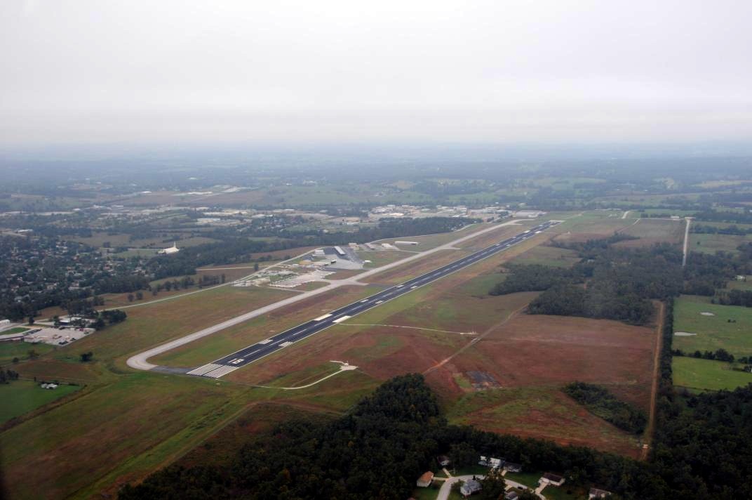
Boone County Airport (IATA: HRO, ICAO: KHRO, FAA LID: HRO), also known as Boone County Regional Airport, is a county-owned public-use airport located three miles (5 km) northwest of the central business district of Harrison, a city in Boone County, Arkansas, United States. The airport serves the surrounding areas including Branson, Missouri. It is mostly used for general aviation but is also served by one commercial airline. Service is subsidized by the Essential Air Service program. Facilities and aircraft
Boone County Airport covers an area of 425 acres (172 ha) which contains one asphalt paved runway (18/36) measuring 6,161 x 150 ft. (1,878 x 46 m).
For the 12-month period ending April 30, 2007, the airport had 16,100 aircraft operations, an average of 44 per day: 77% general aviation, 22% air taxi and 1% military. There are 63 aircraft based at this airport: 78% single engine, 17% multi-engine and 5% jet aircraft.
Airline and destinations
| Airlines |
Destinations |
| SeaPort Airlines |
Memphis , Kansas City |
The above content comes from Wikipedia and is published under free licenses – click here to read more.

Location
& QuickFacts
|
FAA
Information Effective: |
2005-10-27 |
|
Airport
Identifier: |
HRO |
|
Longitude/Latitude: |
093-09-17.0240W/36-15-41.4740N
-93.154729/36.261521 (Estimated) |
|
Elevation: |
1365
ft / 416.05 m (Surveyed) |
|
Land: |
425
acres |
|
From
nearest city: |
3
nautical miles NW of Harrison, AR |
|
Location: |
Boone
County, AR |
|
Magnetic
Variation: |
04E
(1990) |
Owner &
Manager
|
Ownership: |
Publicly
owned |
|
Owner: |
Boone
County |
|
Address: |
100
N Main Suite 300
Harrison, AR 72601 |
|
Phone
number: |
870-741-5760 |
|
Manager: |
Judy
Mc Cutcheon |
|
Address: |
Po
Box 1114
Harrison, AR 72601 |
|
Phone
number: |
870-741-6954 |
Airport
Operations and Facilities
|
Airport
Use: |
Open
to public |
|
Wind
indicator: |
Yes |
|
Segmented
Circle: |
Yes |
|
Control
Tower: |
No |
|
Attendance
Schedule: |
ALL/ALL/ALL |
|
Lighting
Schedule: |
DUSK-DAWN
ACTVT HIRL RY 18/36, REIL RY 18 & MALSR RY 36 - CTAF. |
|
Beacon
Color: |
Clear-Green
(lighted land airport) |
|
Landing
fee charge: |
No |
|
Sectional
chart: |
Kansas
City |
|
Region: |
ASW
- Southwest |
|
Traffic
Pattern Alt: |
836
ft |
|
Boundary
ARTCC: |
ZME
- Memphis |
|
Tie-in
FSS: |
JBR
- Jonesboro |
|
FSS
on Airport: |
No |
|
FSS
Phone: |
870-935-3471 |
|
FSS
Toll Free: |
1-800-WX-BRIEF |
|
NOTAMs
Facility: |
HRO
(NOTAM-d service avaliable) |
|
Federal
Agreements: |
NGXY |
Airport
Communications
|
CTAF: |
123.000 |
|
Unicom: |
123.000 |
Airport
Services
|
Fuel
available: |
100LLA |
|
Airframe
Repair: |
MINOR |
|
Power
Plant Repair: |
MINOR |
|
Bottled
Oxygen: |
NONE |
|
Bulk
Oxygen: |
NONE |
Runway
Information
Runway
18/36
|
Dimension: |
6161
x 150 ft / 1877.9 x 45.7 m |
|
Surface: |
ASPH, Good Condition |
|
Surface Treatment: |
Saw-cut
or plastic Grooved |
|
Weight
Limit: |
Single wheel: 30000
lbs.
Dual wheel: 50000 lbs. |
|
Edge Lights: |
High |
|
|
Runway
18 |
Runway
36 |
| Longitude: |
093-09-13.4012W |
093-09-20.6722W |
|
Latitude: |
36-16-11.7758N |
36-15-11.1408N |
| Elevation: |
1363.00
ft |
1351.00
ft |
|
Alignment: |
127 |
6 |
| ILS
Type: |
|
ILS/DME
|
|
Traffic Pattern: |
Left |
Left |
| Markings: |
Precision
instrument, Good Condition |
Precision
instrument, Good Condition |
|
Crossing Height: |
54.00 ft |
54.00 ft |
| VASI: |
4-box
on left side |
4-box
on left side |
|
Visual Glide
Angle: |
3.00° |
3.00° |
| Approach
lights: |
|
MALSR |
|
Runway End Identifier: |
Yes |
|
|
Radio Navigation
Aids
|
ID |
Type |
Name |
Ch |
Freq |
Var |
Dist |
|
PLK |
NDB |
Point
Lookout/dcmsnd |
|
204.00 |
03E |
22.3
nm |
|
AOV |
NDB |
Bilmart |
|
341.00 |
02E |
48.4 nm |
|
CZE |
NDB |
Clarksville |
|
201.00 |
04E |
49.4
nm |
|
HRO |
VOR/DME |
Harrison |
072X |
112.50 |
04E |
4.4 nm |
|
FLP |
VOR/DME |
Flippin |
075X |
112.80 |
03E |
33.8
nm |
|
RZC |
VORTAC |
Razorback |
111X |
116.40 |
04E |
46.9 nm |
|
DGD |
VORTAC |
Dogwood |
031X |
109.40 |
06E |
47.7
nm |
Remarks
- DEER & BIRDS ON & INVOF ARPT.
Boone County Airport
Address: Boone County, AR
Tel: 870-741-6954
Images and information
placed above are from
http://www.airport-data.com/airport/HRO/
We thank them for the data!
|
General Info |
|
Country |
United States
|
|
State |
ARKANSAS |
|
FAA ID |
HRO |
|
Latitude |
36-15-41.474N
|
|
Longitude |
093-09-17.024W
|
|
Elevation |
1365 feet |
|
Near City |
HARRISON |
We don't guarantee the information is fresh and accurate. The data may be wrong or outdated.
For more up-to-date information please refer to other sources.
|
|