 |
|
Arkansas International Airport |
| Arkansas International Airport |
 |
| USGS aerial image - 25 March 2001 |
| IATA: BYH – ICAO: KBYH – FAA LID: BYH |
| Summary |
| Airport type |
Public |
| Owner |
Gosnell Regional Airport Authority |
| Serves |
Blytheville, Arkansas |
| Elevation AMSL |
254 ft / 77 m |
| Coordinates |
35°57′52″N 089°56′38″W / 35.96444°N 89.94389°W / 35.96444; -89.94389 |
| Runways |
| Direction |
Length |
Surface |
| ft |
m |
| 18/36 |
11,602 |
3,536 |
Concrete |
| Statistics (2009) |
| Aircraft operations |
33,000 |
| Based aircraft |
15 |
| Source: Federal Aviation Administration |
Arkansas Int'l Airport Diagram
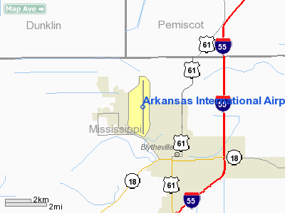
© Jeppesen Sanderson, Inc. Arkansas International Airport (ICAO: KBYH, FAA LID: BYH) is a public use airport located three nautical miles (6 km) northwest of the central business district of Blytheville, a city in Mississippi County, Arkansas, United States. It is owned by the Gosnell Regional Airport Authority. History
Arkansas International Airport was developed from the closed Eaker Air Force Base, after its closure by the United States Air Force on 15 December 1992.
In 2008, Aviation Repair Technologies (ART) established its headquarters at the facility and opened repair facilities for aircraft heavy maintenance, short-term aircraft storage, and aircraft engine disassembly.
- The company's heavy maintenance activities are focused on regional turboprop and jet aircraft, including the ATR 72, ATR 42, CRJ 200, CRJ 700, CRJ 900, Embraer 120, ERJ 135, ERJ 145, ERJ 170, and ERJ 190 aircraft.
- Its aircraft engine disassembly operation, named Turbine Support International (TSI), is a joint venture between ART and Air France-KLM. TSI is focused on disassembly of CFM56, CF6-80, and CF6-50 engine types.
- Also located at the airport is an aircraft jet engine test cell that was constructed in 1991 by the US Air Force and is capable of testing engines that produce up to 56,000 lbs of thrust, including CFM56, CF34, and other popular engine types. Aviation Repair Technologies holds an exclusive lease on the test cell through 2019.
- From its headquarters at the facility, ART also manages a network of thirteen line maintenance facilities located at major airports around the United States.
The facility secured a lease with USA Floral, a major floral distributor based near Washington, D.C., that needed a southern locale for its regular flights to South America to import flowers. USA Floral was expected to create hundreds of jobs in Blytheville.
The Arkansas Archaeological Society hosted a training program at the former air base from 2004-2006. Archaeologists have been studying the Mississippian culture that lived in the region, focusing on the years 900-1600.
Facilities and aircraft
Arkansas International Airport covers an area of 1,100 acres (445 ha) at an elevation of 254 feet (77 m) above mean sea level. It has one runway designated 18/36 with a concrete surface measuring 11,602 by 150 feet (3,536 x 46 m).
For the 12-month period ending August 31, 2009, the airport had 33,000 aircraft operations, an average of 90 per day: 58% general aviation and 42% military. At that time there were 15 aircraft based at this airport: 87% single-engine and 13% multi-engine.
The facility has 1,500,000 square feet (139,000 m) of available space, which makes it the second largest industrial complex in Arkansas. The complex consists of commercial, community, recreation, educational, garage, industrial, office, residential, and warehousing facilities, which makes it very open for many uses.
Because it was an Air Force base, it has room and facilities that are not available in many other complexes. Some of these extra functions include five million square feet of ramp space and 6 full size hangars. These full size hangars are large enough to accommodate a DC-10 or a Boeing 747. Facilities also include a full airplane maintenance and test hangar, with enough space to maintain the planes listed above. These buildings add up to approximately 300,000 square feet (28,000 m).
The airport has the second longest runway in the state of Arkansas at approximately 11,600 feet (3,500 m) in length. The airport also has very reasonable seasonal climate conditions, which makes it convenient for year-round travel. The airport can accommodate up to 50 aircraft, and has large hangar and storage areas for maintenance and repair needs.
The airport also accommodates deployment and pick-up of National Guard troops, as well as training grounds for military flight training maneuvers.
The above content comes from Wikipedia and is published under free licenses – click here to read more.
Location
& QuickFacts
|
FAA Information Effective: |
2005-10-27 |
|
Airport Identifier: |
BYH |
|
Longitude/Latitude: |
089-56-38.2350W/35-57-51.6500N
-89.943954/35.964347 (Estimated) |
|
Elevation: |
254
ft / 77.42 m (Surveyed) |
|
Land: |
1100
acres |
|
From nearest city: |
3
nautical miles NW of Blytheville, AR |
|
Location: |
Mississippi
County, AR |
|
Magnetic Variation: |
01E
(1995) |
Owner
& Manager
|
Ownership: |
Publicly
owned |
|
Owner: |
Gosnell
Reg Airport Authority |
|
Address: |
Po
Box 166
Blytheville, AR 72316-0166 |
|
Phone number: |
870-532-2100 |
|
Manager: |
Jerry
D. Vest |
|
Address: |
Po
Box 166
Blytheville, AR 72316-0166 |
|
Phone number: |
870-532-5628 |
Airport
Operations and Facilities
| Airport
Use: |
Open
to public |
|
Wind
indicator: |
Yes |
|
Segmented
Circle: |
No |
|
Control
Tower: |
No |
|
Attendance
Schedule: |
ALL/MON-FRI/0800-1700
ARPT UNATNDD HOLS. |
|
Lighting
Schedule: |
DUSK-DAWN
ACTVT HIRL RY 18/36 - CTAF. |
|
Beacon
Color: |
Clear-Green
(lighted land airport) |
|
Sectional
chart: |
Memphis |
|
Region: |
ASW
- Southwest |
|
Boundary
ARTCC: |
ZME
- Memphis |
|
Tie-in
FSS: |
JBR
- Jonesboro |
|
FSS
on Airport: |
No |
|
FSS
Phone: |
870-935-3471 |
|
FSS
Toll Free: |
1-800-WX-BRIEF |
|
NOTAMs
Facility: |
BYH
(NOTAM-d service avaliable) |
|
Federal
Agreements: |
N1P |
Airport
Communications
|
CTAF:
122.700 |
Unicom:
122.700 |
|
CTAF:
122.700 |
Unicom:
122.700 |
Airport
Services
|
Fuel
available: 100LLA |
Airframe
Repair: MAJOR |
|
Fuel
available: 100LLA |
Airframe
Repair: MAJOR |
Runway
Information
Runway
18/36
|
Dimension: |
11602 x
150 ft / 3536.3 x 45.7 m |
|
Surface: |
ASPH-CONC,
Good Condition |
|
Weight Limit: |
Single
wheel: 155000 lbs.
Dual wheel: 235000 lbs.
Dual
tandem wheel: 455000 lbs. |
|
Edge Lights: |
Non-standard
lighting system
NSTD HIRL; LCTD 85 FT FM RY EDGE & NSTD DSTC FM CNTRLN.
DEPTH PRECEPTION PROBLEMS MAY EXIST
DURG PERIODS OF DARKNESS. |
|
|
Runway
18 |
Runway
36 |
|
Longitude: |
089-56-38.2320W |
089-56-38.2380W |
|
Latitude: |
35-58-49.0140N |
35-56-54.2860N |
|
Elevation: |
250.00
ft |
252.00
ft |
|
Alignment: |
127 |
0 |
|
ILS Type: |
ILS/DME
|
|
|
Traffic Pattern: |
Left |
Left |
|
Markings: |
Precision
instrument, Fair Condition |
Precision
instrument, Fair Condition |
|
Crossing Height: |
54.00
ft |
51.00
ft |
|
VASI: |
4-box
on left side |
4-box
on left side |
|
Visual Glide Angle: |
3.00° |
3.00° |
|
RVR Equipment: |
touchdown |
touchdown |
|
Approach lights: |
ALSF1 |
SALS |
|
Runway End Identifier: |
No |
No |
|
Centerline Lights: |
No |
No |
|
Touchdown Lights: |
No |
No |
|
Radio
Navigation Aids
|
ID |
Type |
Name |
Ch |
Freq |
Var |
Dist |
|
IUI |
NDB |
Hicks |
|
350.00 |
01E |
5.6
nm |
|
MXA |
NDB |
Manila |
|
282.00 |
01E |
11.3
nm |
|
TKX |
NDB |
Kennett |
|
358.00 |
00E |
16.5
nm |
|
BPW |
NDB |
Osceola |
|
239.00 |
02E |
16.7
nm |
|
DNT |
NDB |
Nally
Dunston |
|
343.00 |
01W |
26.2
nm |
|
PGR |
NDB |
Paragould |
|
383.00 |
01E |
28.2
nm |
|
COO |
NDB |
Covington |
|
326.00 |
02E |
28.5
nm |
|
MIG |
NDB |
Millington |
|
232.00 |
04E |
41.2
nm |
|
SPQ |
NDB |
Spain |
|
414.00 |
04E |
46.2
nm |
|
FD |
NDB |
Earli |
|
278.00 |
03E |
46.2
nm |
|
DXE |
NDB |
Dexter |
|
423.00 |
00E |
49.5
nm |
|
TNZ |
NDB |
Lawrence
County |
|
227.00 |
01E |
49.7
nm |
|
GOJ |
VOR |
Gosnell |
|
111.80 |
01E |
0.8
nm |
|
JBR |
VOR/DME |
Jonesboro |
023X |
108.60 |
02E |
31.8
nm |
|
GQE |
VOR/DME |
Gilmore |
077X |
113.00 |
04E |
45.4
nm |
|
DYR |
VORTAC |
Dyersburg |
115X |
116.80 |
03E |
30.6
nm |
|
MAW |
VORTAC |
Malden |
049X |
111.20 |
03E |
35.5
nm |
|
ARG |
VORTAC |
Walnut
Ridge |
092X |
114.50 |
04E |
49.9
nm |
Remarks
- FOR SVC AFT HRS CALL
870-780-6455; NO FEE CHARGED.
Arkansas
International
Airport
Address:
Mississippi County, AR
Tel:
870-532-5628
Images and information placed above are from
http://www.airport-data.com/airport/BYH/
We thank them for the data!
|
General Info |
|
Country |
United
States |
|
State |
ARKANSAS
|
|
FAA
ID |
BYH
|
|
Latitude |
35-57-51.670N
|
|
Longitude |
089-56-36.420W
|
|
Elevation |
251
feet |
|
Near
City |
BLYTHEVILLE
|
We don't guarantee the information is fresh and accurate. The data may be wrong or outdated.
For more up-to-date information please refer to other sources.
|
|


