|
|
Winslow-lindbergh Regional Airport |
| Winslow-Lindbergh Regional Airport |
 |
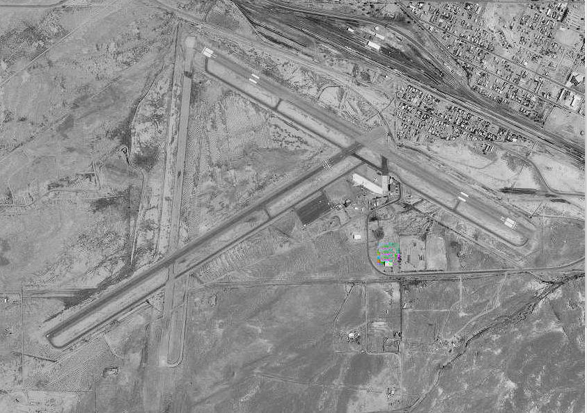
| USGS aerial photo, 1997 |
| IATA: INW – ICAO: KINW – FAA LID: INW |
| Summary |
| Airport type |
Public |
| Owner |
City of Winslow |
| Serves |
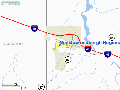
Winslow, Arizona |
| Elevation AMSL |
4,941 ft / 1,506 m |
| Coordinates |
35°01′19″N 110°43′21″W / 35.02194°N 110.7225°W / 35.02194; -110.7225 |
| Runways |
| Direction |
Length |
Surface |
| ft |
m |
| 4/22 |
7,499 |
2,286 |
Asphalt |
| 11/29 |
7,100 |
2,164 |
Asphalt |
| Statistics (2009) |
| Aircraft operations |
19,250 |
| Based aircraft |
11 |
| Source: Federal Aviation Administration |
Winslow-Lindbergh Regional Airport (IATA: INW, ICAO: KINW, FAA LID: INW) is a city-owned public-use airport located one nautical mile (1.85 km) west of the central business district of Winslow, a city in Navajo County, Arizona, United States. The airport is included in the FAA's National Plan of Integrated Airport Systems for 2009–2013, which categorizes it as a general aviation facility. The U.S. Forest Service operates a firefighting Air Tanker base here. The airport is not currently served by any commercial airlines. History
The airport was founded in 1929 by Transcontinental Air Transport as a landing site for a transcontinental air route. During World War II the airfield was used by the United States Army Air Force Air Transport Command as a training base for pilots.
Facilities and aircraft
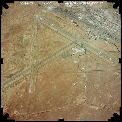
Winslow-Lindbergh Regional Airport covers an area of 900 acres (364 ha) at an elevation of 4,941 feet (1,506 m) above mean sea level. It has two asphalt paved runways: 4/22 is 7,499 by 150 feet (2,286 x 46 m) and 11/29 is 7,100 by 150 feet (2,164 x 46 m).
For the 12-month period ending April 18, 2009, the airport had 19,250 aircraft operations, an average of 52 per day: 99% general aviation and 1% military. At that time there were 11 aircraft based at this airport: 64% single-engine, 27% multi-engine and 9% helicopter.
The above content comes from Wikipedia and is published under free licenses – click here to read more.
Regular Meetings of The Winslow Airport Commission:
 Appointments shall be made for a period of three(3) years
each, with the terms of the members so staggered that no more than two
(2) terms will expire in any one year. In the event of death, resignation
or removal of a member, the vacancy may be filled for only the unexpired
term. The term of all members shall extend until their successors are
qualified. Meetings are held the third Tuesday of the month at 4:00pm,
(unless there is no quorum) and are held at the Airport Terminal Building,
Airport Road, Winslow, Arizona.
Appointments shall be made for a period of three(3) years
each, with the terms of the members so staggered that no more than two
(2) terms will expire in any one year. In the event of death, resignation
or removal of a member, the vacancy may be filled for only the unexpired
term. The term of all members shall extend until their successors are
qualified. Meetings are held the third Tuesday of the month at 4:00pm,
(unless there is no quorum) and are held at the Airport Terminal Building,
Airport Road, Winslow, Arizona.
Location & QuickFacts
|
FAA
Information Effective: |
2005-10-27 |
|
Airport Identifier: |
INW |
|
Longitude/Latitude: |
110-43-21.1000W/35-01-18.9000N
-110.722528/35.021917 (Estimated) |
|
Elevation: |
4941 ft / 1506.02 m (Surveyed) |
|
Land: |
900 acres |
|
From nearest city: |
1
nautical miles W of Winslow, AZ |
|
Location: |
Navajo County, AZ |
|
Magnetic Variation: |
13E (1985) |
Owner & Manager
|
Ownership: |
Publicly owned |
|
Owner: |
City Of Winslow |
|
Address: |
21 Williamson Ave
Winslow, AZ 86047 |
|
Phone number: |
928-289-2422 |
|
Manager: |
John Roche
NORM STEWARD, AMGR, 928-289-2429 |
|
Address: |
21 Williamson Ave
Winslow, AZ 86047 |
|
Phone number: |
928-289-2423
JOHN R. ROCHE, JR., CITY ADMINISTRATOR (928) 289-2423. |
Airport Operations and Facilities
|
Airport
Use: |
Open to public |
|
Wind indicator: |
Yes |
|
Segmented Circle: |
Yes |
|
Control Tower: |
No |
|
Attendance Schedule: |
NOV-MAR/ALL/0800-1700,APR-OCT/ALL/0700-1800 |
|
Lighting Schedule: |
DUSK-DAWN
DURG DALGT HRS ACTVT REIL RYS 11 & 22; VASI RYS 11 & 29
& 22 - CTAF. |
|
Beacon Color: |
Clear-Green (lighted land airport) |
|
Landing fee charge: |
No
LANDING FEE FOR COMMERICAL ACFT. OVERNIGHT TIEDOWN FEE. |
|
Sectional chart: |
Phoenix |
|
Region: |
AWP - Western-Pacific |
|
Traffic Pattern
Alt: |
1000 ft |
|
Boundary ARTCC: |
ZAB - Albuquerque |
|
Tie-in FSS: |
PRC - Prescott |
|
FSS on Airport: |
No |
|
FSS Phone: |
928-778-7810 |
|
FSS Toll Free: |
1-800-WX-BRIEF |
|
NOTAMs Facility: |
INW (NOTAM-d service avaliable) |
|
Federal Agreements: |
NGPY3 |
Airport Communications
|
CTAF: |
122.800 |
|
Unicom: |
122.800 |
Airport Services
|
Fuel
available: |
100LLA |
|
Airframe
Repair: |
MINOR |
|
Power
Plant Repair: |
MINOR |
|
Bottled Oxygen: |
NONE |
|
Bulk Oxygen: |
NONE |
Runway Information
Runway 04/22
|
Dimension: |
7499
x 150 ft / 2285.7 x 45.7 m |
|
Surface: |
ASPH,
Good Condition |
|
Weight Limit: |
Single
wheel: 50000 lbs.
Dual wheel: 80000 lbs.
Dual tandem wheel: 125000 lbs. |
|
Edge Lights: |
Medium |
|
|
Runway 04 |
Runway 22 |
|
Longitude: |
110-44-16.3610W |
110-42-59.4220W |
|
Latitude: |
35-00-51.3680N |
35-01-29.9930N |
|
Elevation: |
4941.00 ft |
4881.00 ft |
|
Alignment: |
59 |
127 |
|
Traffic Pattern: |
Left |
Left |
|
Markings: |
Basic, Fair Condition |
Basic, Fair Condition |
|
Crossing Height: |
0.00 ft |
26.00 ft |
|
Displaced threshold: |
0.00 ft |
1258.00 ft |
|
VASI: |
|
4-box on left side
VASI RY 22 OTS INDEFLY. |
|
Visual Glide Angle: |
0.00� |
3.00� |
|
Runway End Identifier: |
No |
Yes
RY 22 REIL OTS INDEFLY. |
|
Centerline Lights: |
No |
No |
|
Touchdown Lights: |
No |
No |
|
Obstruction: |
72
ft pole, 1917.0 ft from runway, 130 ft left of centerline,
23:1 slope to clear |
30
ft poles, 400.0 ft from runway, 6:1 slope to clear
APCH RATIO 50:1 TO DSPLCD THR.
CONT FLOOD DITCH 10 FT DEEP & +4 FT DIKE 50 FT FROM EOR. |
|
Runway 11/29
|
Dimension: |
7100
x 150 ft / 2164.1 x 45.7 m |
|
Surface: |
ASPH,
Good Condition |
|
Weight Limit: |
Single
wheel: 60000 lbs.
Dual wheel: 70000 lbs.
Dual tandem wheel: 110000 lbs. |
|
Edge Lights: |
Medium |
|
|
Runway 11 |
Runway 29 |
|
Longitude: |
110-43-40.3580W |
110-42-26.1980W |
|
Latitude: |
35-01-44.9040N |
35-01-10.1520N |
|
Elevation: |
4899.00 ft |
4870.00 ft |
|
Alignment: |
120 |
127 |
|
Traffic Pattern: |
Right |
Left |
|
Markings: |
Non-precision instrument, Poor Condition |
Non-precision instrument, Poor Condition |
|
Crossing Height: |
40.00 ft |
26.00 ft |
|
Displaced threshold: |
0.00 ft |
373.00 ft |
|
VASI: |
4-box on left side |
4-box on left side |
|
Visual Glide Angle: |
3.00� |
3.00� |
|
Runway End Identifier: |
Yes |
No |
|
Centerline Lights: |
No |
No |
|
Touchdown Lights: |
No |
No |
|
Obstruction: |
19
ft tree, 591.0 ft from runway, 90 ft left of centerline, 20:1
slope to clear |
42
ft tower, 1008.0 ft from runway, 19:1 slope to clear
APCH RATIO 32:1 TO DSPLCD THR.
+4 FT FENCE 200 FT FROM RY END; ACROSS RY END. |
|
Radio Navigation Aids
|
ID |
Type |
Name |
Ch |
Freq |
Var |
Dist |
|
PUU |
NDB |
Pulliam |
|
379.00 |
13E |
47.2
nm |
|
FLG |
VOR/DME |
Flagstaff |
085Y |
113.85 |
14E |
47.4
nm |
|
INW |
VORTAC |
Winslow |
073X |
112.60 |
14E |
4.3
nm |
Remarks
-
FBO OPER NOV-MAR 0800-1700.
-
ESTABD PRIOR TO 1959.
Based Aircraft
|
Aircraft
based on field: |
9 |
|
Single Engine Airplanes: |
7 |
|
Multi Engine Airplanes: |
2 |
Operational Statistics
|
Aircraft
Operations: |
76/Day |
|
Air Taxi: |
13.2% |
|
General Aviation
Local: |
14.5% |
|
General Aviation
Itinerant: |
54.2% |
|
Military: |
18.1% |
Winslow-lindbergh Regional Airport
Address:
Navajo County,
AZ
Airport Road
Winslow, Arizona 86047
Phone: (928) 289-2429
Fax: (928) 289-9298
URL: http://ci.winslow.az.us/airport.html
|
 |
(Click on the photo to
enlarge) |
Images and information placed above are from
http://www.airport-data.com/airport/INW/
http://www.dot.state.az.us/aviation/airports/airports_list.asp?FAA=INW
http://ci.winslow.az.us/airport.html
We thank them for the data!
| General
Info |
| Country |
United
States |
| State |
ARIZONA
|
| FAA ID |
INW |
| Latitude |
35-01-18.900N
|
| Longitude |
110-43-21.100W
|
| Elevation |
4941 feet
|
| Near City |
WINSLOW
|
We don't guarantee the information is fresh and accurate. The data may be wrong or outdated.
For more up-to-date information please refer to other sources.
|
|