|
|
| Window Rock Airport |
| IATA: none – ICAO: KRQE – FAA LID: RQE |
| Summary |
| Airport type |
Public |
| Operator |
The Navajo Nation |
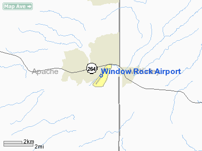
| Location |
Window Rock, Arizona |
| Elevation AMSL |
6,742 ft / 2,055 m |
| Coordinates |
35°39′07″N 109°04′03″W / 35.65194°N 109.0675°W / 35.65194; -109.0675Coordinates: 35°39′07″N 109°04′03″W / 35.65194°N 109.0675°W / 35.65194; -109.0675 |
| Runways |
| Direction |
Length |
Surface |
| ft |
m |
| 2/20 |
7,000 |
2,134 |
Asphalt |
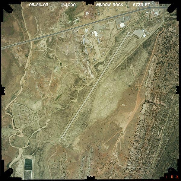
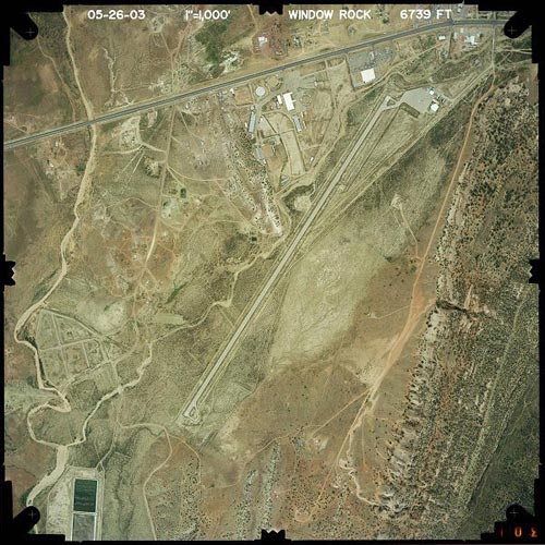
Window Rock Airport (ICAO: KRQE, FAA LID: RQE) is a public-use general aviation airport located one mile (1.6 km) south of the central business district of Window Rock, a city in Apache County, Arizona, United States.
This is one of six airports owned by the Navajo Nation; the other five being Chinle Airport (E91), Kayenta Airport (0V7) and Tuba City Airport (T03) in Arizona, plus Crownpoint Airport (0E8) and Shiprock Airport (5V5) in New Mexico.
Facilities
Window Rock Airport covers an area of 88 acres (36 ha) and has one runway:
- Runway 2/20: 7,000 x 75 ft (2,134 x 23 m), Surface: Asphalt
The above content comes from Wikipedia and is published under free licenses – click here to read more.
Location & QuickFacts
|
FAA
Information Effective: |
2005-10-27 |
|
Airport Identifier: |
RQE |
|
Longitude/Latitude: |
109-04-02.6000W/35-39-07.4000N
-109.067389/35.652056 (Estimated) |
|
Elevation: |
6742 ft / 2054.96 m (Surveyed) |
|
Land: |
88 acres |
|
From nearest city: |
1
nautical miles S of Window Rock, AZ |
|
Location: |
Apache County, AZ |
|
Magnetic Variation: |
13E (1980) |
Owner & Manager
|
Ownership: |
Publicly owned |
|
Owner: |
Navajo Nation-c/o Navajo Dot |
|
Address: |
P.o. Box 4620
Window Rock, AZ 86515 |
|
Phone number: |
520-871-6466 |
|
Manager: |
Wayne Hunter |
|
Address: |
P.o. Box 706
Window Rock, AZ 86515 |
|
Phone number: |
520-871-6466 |
Airport Operations and Facilities
|
Airport
Use: |
Open to public |
|
Wind indicator: |
Yes |
|
Segmented Circle: |
No |
|
Control Tower: |
No |
|
Attendance Schedule: |
ALL/MON-FRI/0800-1700 |
|
Lighting Schedule: |
DUSK-DAWN
ACTVT MIRL RY 02/20 & REIL RY 02 - CTAF. |
|
Beacon Color: |
Yellow (unlighted seaplane base)
BCN OTS INDEFLY. |
|
Landing fee charge: |
No |
|
Sectional chart: |
Denver |
|
Region: |
AWP - Western-Pacific |
|
Boundary ARTCC: |
ZAB - Albuquerque |
|
Tie-in FSS: |
PRC - Prescott |
|
FSS on Airport: |
No |
|
FSS Phone: |
928-778-7810 |
|
FSS Toll Free: |
1-800-WX-BRIEF |
|
NOTAMs Facility: |
RQE (NOTAM-d service avaliable) |
|
Federal Agreements: |
NGY |
Airport Communications
|
CTAF: |
122.800 |
|
Unicom: |
122.800 |
Airport Services
|
Airframe
Repair: |
NONE |
|
Power
Plant Repair: |
NONE |
|
Bottled
Oxygen: |
NONE |
|
Bulk
Oxygen: |
NONE |
Runway Information
Runway 02/20
|
Dimension: |
7000
x 75 ft / 2133.6 x 22.9 m |
|
Surface: |
ASPH,
Fair Condition |
|
Weight Limit: |
Single
wheel: 30000 lbs.
Dual wheel: 45000 lbs.
Dual tandem wheel: 75000 lbs. |
|
Edge Lights: |
Medium |
|
|
Runway 02 |
Runway 20 |
|
Longitude: |
109-04-26.2980W |
109-03-38.8090W |
|
Latitude: |
35-38-38.7740N |
35-39-36.1130N |
|
Elevation: |
6702.00 ft |
6742.00 ft |
|
Alignment: |
34 |
127 |
|
Traffic Pattern: |
Left |
Right |
|
Markings: |
Basic, Good Condition |
Basic, Good Condition |
|
Crossing Height: |
36.00 ft |
0.00 ft |
|
VASI: |
2-light PAPI on left side |
|
|
Visual Glide Angle: |
3.00� |
0.00� |
|
Runway End Identifier: |
Yes |
No |
|
Centerline Lights: |
No |
No |
|
Touchdown Lights: |
No |
No |
|
Obstruction: |
18
ft hill, 645.0 ft from runway, 125 ft right of centerline,
24:1 slope to clear
4 FT FENCE 195 FT FM EOR. |
8
ft trees, 400.0 ft from runway, 100 ft right of centerline,
24:1 slope to clear
4 FT FENCE 195 FT FM EOR. |
|
Radio Navigation Aids
|
ID |
Type |
Name |
Ch |
Freq |
Var |
Dist |
|
AWR |
NDB |
Window
Rock |
|
254.00 |
12E |
0.7
nm |
|
GUP |
VORTAC |
Gallup |
098X |
115.10 |
14E |
14.2
nm |
|
ZUN |
VORTAC |
Zuni |
081X |
113.40 |
14E |
41.5
nm |
Remarks
-
HILLS AND CLIFFS ALL
QUADRANTS.
-
TURBULENCE MAY BE EXPERIENCED
INVOF ARPT.
-
LIVESTOCK ON & INVOF
ARPT.
-
NORTH TWY CLSD INDEFLY.
-
RY 02/20 CLSD TO ACFT
OVER 24,000 LBS INDEFLY.
Based Aircraft
|
Aircraft
based on field: |
8 |
|
Single Engine Airplanes: |
3 |
|
Multi Engine Airplanes: |
5 |
Operational Statistics
|
Aircraft
Operations: |
135/Week |
|
General Aviation
Local: |
21.4% |
|
General Aviation
Itinerant: |
78.6% |
Window Rock Airport
Address:
Apache County, AZ
Tel:
520-871-6466
|
 |
(Click on the photo to
enlarge) |
Images and information placed above are from
http://www.airport-data.com/airport/RQE/
http://www.dot.state.az.us/aviation/airports/airports_list.asp?FAA=RQE
We thank them for the data!
| General
Info |
| Country |
United
States |
| State |
ARIZONA
|
| FAA ID |
RQE |
| Latitude |
35-39-07.400N
|
| Longitude |
109-04-02.600W
|
| Elevation |
6742 feet
|
| Near City |
WINDOW
ROCK |
We don't guarantee the information is fresh and accurate. The data may be wrong or outdated.
For more up-to-date information please refer to other sources.
|
|