|
|
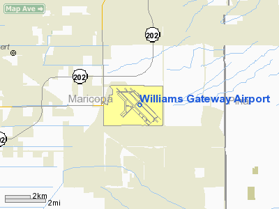
| Phoenix-Mesa Gateway Airport |
 |
| IATA: AZA – ICAO: KIWA – FAA LID: IWA |
| Summary |
| Airport type |
Public |
| Owner |
Williams Gateway Airport Authority |
| Location |
Mesa, Arizona |
| Elevation AMSL |
1,382 ft / 421 m |
| Coordinates |
33°18′28″N 111°39′20″W / 33.30778°N 111.65556°W / 33.30778; -111.65556 |
| Website |
PhxMesaGateway.org |
| Runways |
| Direction |
Length |
Surface |
| ft |
m |
| 12C/30C |
10,200 |
3,109 |
Asphalt/Concrete |
| 12L/30R |
9,300 |
2,835 |
Concrete |
| 12R/30L |
10,400 |
3,170 |
Concrete |
| Statistics (2005) |
| Aircraft operations |
276,642 |
| Based aircraft |
114 |
| Source: Federal Aviation Administration |
Phoenix-Mesa Gateway Airport (IATA: AZA, ICAO: KIWA, FAA LID: IWA), formerly Williams Gateway Airport and formerly Williams Air Force Base, is a commercial airport located in the southeastern area of the city of Mesa, Arizona, and 20 miles (32 km) southeast of Phoenix, in Maricopa County, Arizona, United States. The airport is owned and operated by the Williams Gateway Airport Authority. It serves as a focus city for Allegiant Air. The airport authority is governed by a five member board, composed of the mayors and tribal governor of the town of Gilbert, city of Mesa, town of Queen Creek, Gila River Indian Community and the city of Phoenix.
As per Federal Aviation Administration records, the airport had 1,655 passenger boardings (or enplanements) in calendar year 2005 and 3,790 enplanements (all unscheduled) in 2006. According to the FAA's National Plan of Integrated Airport Systems for 2007–2011, Phoenix-Mesa Gateway was designated as a reliever airport, which is a general aviation airport that may be used to relieve congestion at a large commercial service airport. Allegiant Air began offering scheduled commercial service from this airport in October 2007.
Although most U.S. airports use the same three-letter location identifier for the FAA and IATA, Phoenix-Mesa Gateway Airport is assigned IWA by the FAA and AZA by the IATA (which assigned IWA to Yuzhny Airport in Ivanovo, Russia). The airport's former IATA code was CHD. History
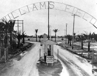
Phoenix-Mesa Gateway Airport was built in 1941 and inaugurated in 1942 by the United States military as Williams Air Base. It served as a flight training field during World War II for military pilots. Military forces established a pilot school there, and many war airplanes that are now considered to be classics were seen there on a daily basis.
In 1948, Williams became the first jet training base, and in 1966 it was the first site of the Undergraduate Pilot Training (UPT) program.
The 1991 Base Realignment and Closure (BRAC) Commission recommended closing the base as its operating costs were too costly for the United States government; the base continued operating until 1993.
 | |
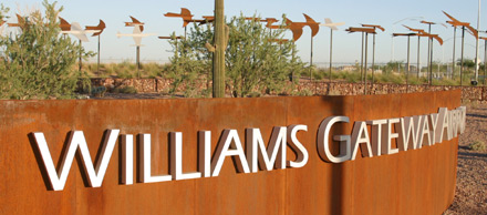
Entrance to Phoenix-Mesa Gateway Airport
|
As the base was being shut down, it was decided that, with the growing traffic at Sky Harbor International Airport in Phoenix, an alternative airport would be needed in the area. The runway was expanded to accommodate jets, and the facility reopened in 1994 as Williams Gateway Airport. Bids began to be made for some airlines to begin flights almost immediately.
In 2004, charter airline Ryan International Airlines began offering MD-82 jet flights from there to Bullhead City International Airport in Bullhead City, Arizona, which is adjacent to Laughlin, Nevada, and many resorts.
In recent years, the airport has again become a center of flight training. Several large flight schools now take advantage of the great flying weather in the Phoenix valley.
 | |
Logo using airport's former name
|
On July 31, 2007, the low-cost Las Vegas-based carrier Allegiant Air announced plans to open a focus city from Phoenix-Mesa Gateway Airport, connecting the Phoenix metropolitan area to 13 destinations. First service commenced on October 25, 2007 and additional cities commencing throughout the remainder of October and complete by November 21, 2007.
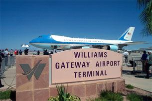
In a press release on September 17, 2007, the Williams Gateway Airport Authority governing board approved a name change for Williams Gateway Airport effective October 15, 2007, after which the airport would be known as the Phoenix-Mesa Gateway Airport. The board cited a desire "to have the airport reach its highest potential in creating jobs and commercial service development" as the reason behind the change.
Facilities and aircraft
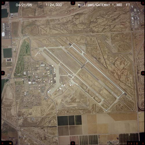
Phoenix-Mesa Gateway Airport covers an area of 3,020 acres (1,222 ha) which contains three paved runways:
- Runway 12C/30C: 10,200 x 150 ft (3,109 x 46 m), Surface: Asphalt/Concrete
- Runway 12L/30R: 9,300 x 150 ft (2,835 x 46 m), Surface: Concrete
- Runway 12R/30L: 10,400 x 150 ft (3,170 x 46 m), Surface: Concrete
For the 12-month period ending December 31, 2006, the airport had 280,719 aircraft operations, an average of 769 per day: 93% general aviation, 4% military, 3% air taxi and <1% scheduled commercial. There are 111 aircraft based at this airport: 58% single-engine, 8% multi-engine, 19% jet and 15% helicopter.
Airlines and destinations
 | |
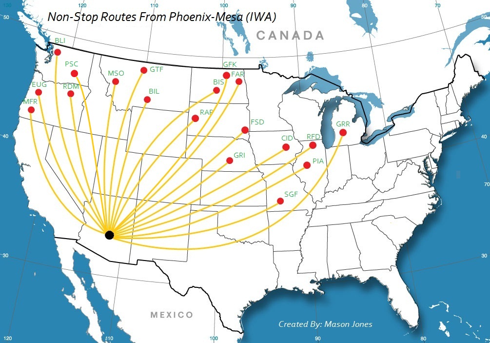
Destinations served from Phoenix-Mesa Gateway Airport
|
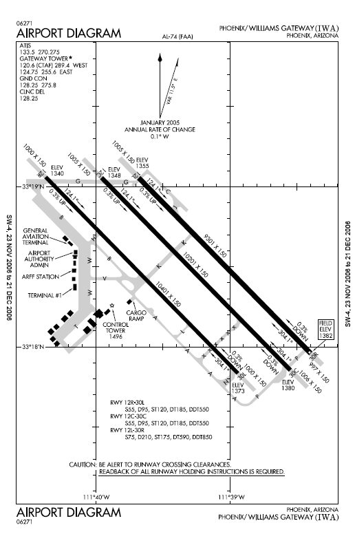 | |
FAA diagram of AZA
|
| Airlines |
Destinations |
| Allegiant Air |
Bellingham, Billings, Bismarck, Bozeman [begins November 12], Cedar Rapids/Iowa City, Chicago/Rockford, Colorado Springs, Eugene, Fargo, Fayetteville (AR) [begins November 18], Fort Collins [begins October 8], Grand Forks, Grand Island, Grand Rapids, Great Falls, Idaho Falls [begins November 12], Medford, Missoula, Moline [begins November 18], Peoria, Pasco, Rapid City, Redmond/Bend, Sioux Falls, South Bend, Springfield (MO), Wichita |
Other
- Air Evac (Medevac airline)
- Fighter Combat International
Training
- Advanced Training Systems International, a fighter combat and maintenance training school
- Mesa Pilot Development
- Airline Transport Professionals
- University of North Dakota Aerospace
- Chandler Gilbert Community College A&P Training
Board of directors
In 1994, the Willams Gateway Airport Authority was established with a three member board with representation from the three cities immediately adjacent to Williams Field. The original governing board consisted of the mayors of the town of Gilbert, city of Mesa, and town of Queen Creek, who continue as members today.
In later years, the Gila River Indian Community and the city of Phoenix joined the Williams Gateway Airport Authority board. Gila River Indian Community joined in 1995 and the City of Phoenix joined in 2006.
Now that the change of the Williams Gateway Airport name to Phoenix-Mesa Gateway Airport has occurred, the board approved resolution and ordinance does not change, diminish, give away, negate nor reduce any of the five board of directors and their respective city, town or tribal government member voting authority and respective ownership. Phoenix-Mesa Gateway Airport continues to be owned and operated by the Williams Gateway Airport Authority.
A five-member airport Board of Directors is composed of elected officials from neighboring cities and a tribal government. Authority communities are as of 2007:
- Gilbert
- Gila River Indian Community
- Mesa
- Queen Creek
- Phoenix
The above content comes from Wikipedia and is published under free licenses – click here to read more.
Williams Gateway Airport in Mesa/Phoenix, Arizona, offers
the perfect climate for aerospace. In addition to being a reliever to
Phoenix Sky Harbor International Airport, Williams Gateway serves a variety
of aircraft including corporate, cargo, general aviation and military.
The airport's three expansive runways (10,401 feet; 10,201 feet; and 9,301
feet) allow for excellent access for every type of aircraft operation
from a single-engine Cessna to the Boeing 747-400.
 WGA
is developing as an international aerospace center with aircraft manufacturing,
maintenance, modification, testing and pilot training. Currently, more
than 20 aviation companies operate on the facility, and the remaining
1,000 acres available for aviation company locations is in high demand. WGA
is developing as an international aerospace center with aircraft manufacturing,
maintenance, modification, testing and pilot training. Currently, more
than 20 aviation companies operate on the facility, and the remaining
1,000 acres available for aviation company locations is in high demand.
In addition to the area's skilled labor force, excellent
year-round flying weather and access to international markets, WGA's assets
make it a prime location for global-minded companies. WGA has been designated
as foreign Trade Zone #221 as well as a Military Reuse Zone, offering
aviation companies a significant financial edge in the global marketplace.
WGA is governed by an airport authority consisting of
Mesa, Gilbert, Queen Creek and the Gila River Indian Community. Because
of its successful conversion from Williams Air Force Base, other base
reuse facilities across the country now look to WGA and its board for
direction in their own redevelopment efforts. WGA now has more than 1,000
jobs and is on its way to becoming a major employment hub for high paying
jobs in the East Valley. The airport's current annual economic impact
on the community is more than $251 million and continues to grow exponentially
as development progresses.
History
 The
former Williams Air Force Base played a strategic role in America's aviation
history. Over a span of 52 years, more than 26,500 men and women earned
their wings at Williams. Gearing up for the combat pilot demands of World
War II, the Army Air Corps broke ground in Southeast Mesa, Ariz. for its
Advanced Flying School on July 16, 1941. In February 1942, the growing
military base's name was changed to Williams Field to honor Charles Linton
Williams, an Arizona-born pilot. The facility was redesignated as Williams
Air Force Base (WAFB) in January 1948. WAFB was the U.S. Air Force's foremost
pilot training facility, graduating more student pilots and instructors
than any other base in the country and supplying 25 percent of the Air
Force's pilots annually. WAFB provided training for a variety of fighter
and bomber aircraft including the AT-9, AT-17, P-38, AT-6, B-17, B-24,
P-51, P-47, F-86, F-100, T-37 and T-38. The
former Williams Air Force Base played a strategic role in America's aviation
history. Over a span of 52 years, more than 26,500 men and women earned
their wings at Williams. Gearing up for the combat pilot demands of World
War II, the Army Air Corps broke ground in Southeast Mesa, Ariz. for its
Advanced Flying School on July 16, 1941. In February 1942, the growing
military base's name was changed to Williams Field to honor Charles Linton
Williams, an Arizona-born pilot. The facility was redesignated as Williams
Air Force Base (WAFB) in January 1948. WAFB was the U.S. Air Force's foremost
pilot training facility, graduating more student pilots and instructors
than any other base in the country and supplying 25 percent of the Air
Force's pilots annually. WAFB provided training for a variety of fighter
and bomber aircraft including the AT-9, AT-17, P-38, AT-6, B-17, B-24,
P-51, P-47, F-86, F-100, T-37 and T-38.
 WAFB
was closed in 1993 and created a loss of more than 3,800 jobs and $300
million in annual economic activity. The state and communities began work
immediately to redevelop the base after the announcement of closure in
1991. The Governor's Economic Reuse Advisory Board was appointed by then
Governor Fife Symington in 1991 to coordinate reuse efforts. The Williams
Air Force Base Economic Reuse Plan was spearheaded by the Reuse Advisory
Board and approved by the Governor of Arizona in 1992. The plan determined
the base be developed as an aerospace center and an educational, research
and training facility with the airport serving as a reliever to Phoenix
Sky Harbor International Airport. Aviation uses identified included commercial
passenger service, aircraft manufacturing, maintenance, modification,
air cargo operations and flight training. WAFB
was closed in 1993 and created a loss of more than 3,800 jobs and $300
million in annual economic activity. The state and communities began work
immediately to redevelop the base after the announcement of closure in
1991. The Governor's Economic Reuse Advisory Board was appointed by then
Governor Fife Symington in 1991 to coordinate reuse efforts. The Williams
Air Force Base Economic Reuse Plan was spearheaded by the Reuse Advisory
Board and approved by the Governor of Arizona in 1992. The plan determined
the base be developed as an aerospace center and an educational, research
and training facility with the airport serving as a reliever to Phoenix
Sky Harbor International Airport. Aviation uses identified included commercial
passenger service, aircraft manufacturing, maintenance, modification,
air cargo operations and flight training.
 To
work toward ownership and operation of the airport, an Intergovernmental
Agreement Group (IGA) was established on Oct. 15, 1992. The IGA developed
legislation to create the Williams Gateway Airport Authority (WGAA). The
airport officially opened in March 1994 and the WGAA was established in
May 1994; this allowed the IGA to be dissolved. Today, the WGAA Board
consists of the mayors from the City of Mesa and Towns of Gilbert and
Queen Creek and the Governor of the Gila River Indian Community. To
work toward ownership and operation of the airport, an Intergovernmental
Agreement Group (IGA) was established on Oct. 15, 1992. The IGA developed
legislation to create the Williams Gateway Airport Authority (WGAA). The
airport officially opened in March 1994 and the WGAA was established in
May 1994; this allowed the IGA to be dissolved. Today, the WGAA Board
consists of the mayors from the City of Mesa and Towns of Gilbert and
Queen Creek and the Governor of the Gila River Indian Community.
Cooperation among the various jurisdictions surrounding
Williams Gateway Airport, the campus and the business community, coupled
with innovative planning efforts has set the stage for successful development
of Williams Gateway Airport for civilian use.
Location & QuickFacts
|
FAA
Information Effective: |
2005-10-27 |
|
Airport Identifier: |
IWA |
|
Longitude/Latitude: |
111-39-19.7000W/33-18-28.2000N
-111.655472/33.307833 (Estimated) |
|
Elevation: |
1382 ft / 421.23 m (Surveyed) |
|
Land: |
3020 acres |
|
From nearest city: |
20 nautical miles SE of Phoenix, AZ |
|
Location: |
Maricopa County, AZ |
|
Magnetic Variation: |
13E (1980) |
Owner & Manager
|
Ownership: |
Publicly owned |
|
Owner: |
Williams Gateway Airport Auth |
|
Address: |
6001 Sossaman Rd
Mesa, AZ 85212 |
|
Phone
number: |
480-988-7600 |
|
Manager: |
Lynn Kusy
ARPT OPERATIONS DIR - WALT FIX(480) 988-7709. |
|
Address: |
6001 Sossaman Rd
Mesa, AZ 85212-0212 |
|
Phone
number: |
480-988-7700 |
Airport Operations and Facilities
|
Airport
Use: |
Open to public |
|
Wind indicator: |
Yes |
|
Segmented Circle: |
Yes |
|
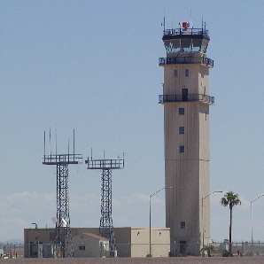
Control Tower: |
Yes |
|
Attendance Schedule: |
ALL/ALL/ALL |
|
Lighting Schedule: |
DUSK-DAWN |
|
Beacon Color: |
Clear-Green (lighted land airport) |
|
Landing fee charge: |
Yes
NO LDG FEE FOR US GOV OWNED, NON-REVENUE AND FLIGHT TRAINING ACFT
UP TO 35,000 LBS. |
|
Sectional chart: |
Phoenix |
|
Region: |
AWP - Western-Pacific |
|
Traffic Pattern
Alt: |
1218 ft |
|
Boundary ARTCC: |
ZAB - Albuquerque |
|
Tie-in FSS: |
PRC - Prescott |
|
FSS on Airport: |
No |
|
FSS Phone: |
928-778-7810 |
|
FSS Toll Free: |
1-800-WX-BRIEF |
|
NOTAMs Facility: |
IWA (NOTAM-d service avaliable) |
|
Certification type/date: |
BU 3/1999 |
|
Federal Agreements: |
N |
Airport Communications
Airport Services
|
Fuel
available: |
100LLA |
|
Airframe
Repair: |
MINOR |
|
Bottled Oxygen: |
HIGH/LOW |
Runway
Information
Runway 12C/30C
|
Dimension: |
10201
x 150 ft / 3109.3 x 45.7 m |
|
Surface: |
ASPH-CONC, Good Condition
RY 12C FIRST 1000 FT CONC, RY 30 C FIRST 3500 FT CONC, REMAINING
CENTER PORTION ASPH. |
|
Weight Limit: |
Single
wheel: 55000 lbs.
Dual wheel: 95000 lbs.
Dual tandem wheel: 185000 lbs.
Dual dual tandem wheel: 550000 lbs. |
|
Edge Lights: |
Medium |
|
|
Runway 12C |
Runway 30C |
|
Longitude: |
111-39-57.3230W |
111-38-33.1880W |
|
Latitude: |
33-19-03.4030N |
33-17-51.3350N |
|
Elevation: |
1348.00 ft |
1380.00 ft |
|
Alignment: |
127 |
127 |
|
ILS Type: |
|
LOC/GS |
|
Traffic Pattern: |
Left |
Left |
|
Markings: |
Precision instrument, Good Condition |
Precision instrument, Good Condition |
|
Arresting: |
MA1A |
MA1A |
|
Crossing Height: |
50.00 ft |
41.00 ft |
|
VASI: |
4-light PAPI on left side |
4-light PAPI on left side |
|
Visual Glide Angle: |
3.00� |
3.00� |
|
Runway 12L/30R
|
Dimension: |
9301
x 150 ft / 2834.9 x 45.7 m |
|
Surface: |
CONC,
Good Condition
RY 12C FIRST 1000 FT CONC, RY 30 C FIRST 3500 FT CONC, REMAINING
CENTER PORTION ASPH. |
|
Weight Limit: |
Single
wheel: 75000 lbs.
Dual wheel: 210000 lbs.
Dual tandem wheel: 590000 lbs.
Dual dual tandem wheel: 850000 lbs. |
|
Edge Lights: |
High |
|
|
Runway 12L |
Runway 30R |
|
Longitude: |
111-39-40.7290W |
111-38-24.0180W |
|
Latitude: |
33-19-03.3240N |
33-17-57.6060N |
|
Elevation: |
1354.00 ft |
1382.00 ft |
|
Alignment: |
127 |
127 |
|
Traffic Pattern: |
Left |
Right |
|
Markings: |
Precision instrument, Good Condition |
Precision instrument, Good Condition |
|
Arresting: |
MA1A |
MA1A |
|
Crossing Height: |
74.00 ft |
75.00 ft |
|
VASI: |
4-light PAPI on left side |
4-light PAPI on left side |
|
Visual Glide Angle: |
3.00� |
3.00� |
|
Runway End Identifier: |
Yes |
Yes |
|
Runway 12R/30L
|
Dimension: |
10401
x 150 ft / 3170.2 x 45.7 m |
|
Surface: |
CONC,
Good Condition
RY 12C FIRST 1000 FT CONC, RY 30 C FIRST 3500 FT CONC, REMAINING
CENTER PORTION ASPH. |
|
Weight Limit: |
Single
wheel: 55000 lbs.
Dual wheel: 95000 lbs.
Dual tandem wheel: 185000 lbs.
Dual dual tandem wheel: 550000 lbs. |
|
Edge Lights: |
Medium |
|
|
Runway 12R |
Runway 30L |
|
Longitude: |
111-40-22.3230W |
111-38-56.5360W |
|
Latitude: |
33-19-03.6140N |
33-17-50.1420N |
|
Elevation: |
1340.00 ft |
1373.00 ft |
|
Alignment: |
127 |
127 |
|
Traffic Pattern: |
Right |
Left |
|
Markings: |
Precision instrument, Good Condition |
Precision instrument, Good Condition |
|
Arresting: |
MA1A |
MA1A |
|
Centerline Lights: |
|
No |
|
Radio Navigation Aids
|
ID |
Type |
Name |
Ch |
Freq |
Var |
Dist |
|
CHD |
NDB |
Chandler |
|
407.00 |
12E |
8.1
nm |
|
FFZ |
NDB |
Falcon
Field |
|
281.00 |
12E |
10.0
nm |
|
SDL |
NDB |
Scottsdale |
|
224.00 |
12E |
23.1
nm |
|
GAZ |
NDB |
Globe |
|
255.00 |
13E |
49.7
nm |
|
LUF |
TACAN |
Luke |
077X |
|
13E |
38.9
nm |
|
IWA |
VORTAC |
Willie |
080X |
113.30 |
13E |
0.3
nm |
|
PXR |
VORTAC |
Phoenix |
103X |
115.60 |
12E |
17.5
nm |
|
TFD |
VORTAC |
Stanfield |
095X |
114.80 |
12E |
28.4
nm |
|
PHX |
VOT |
Phoenix
Sky Harbor |
|
109.00 |
|
19.3
nm |
Remarks
-
VOLUNTARY NOISE ABATEMENT
PROCEDURES IN EFFECT. AVOID LOW OVERFLIGHT OF NOISE SENSITIVE AREAS
SURROUNDING ARPT. FOR NOISE ABATEMENT INFO CTC ARPT OPNS 602-565-7967
BTN 0600-2200 OR 480-988-7700 BTN 2200-0600.
-
TWY K SOUTH OF TWY A
CLSD INDEFLY.
-
BE ALERT TO INTENSE
HELICOPTER TRAINING ACTIVITY DURING DAYLIGHT HRS.
-
TRANSIENT PARKING ON
THE MIDDLE RAMP ONLY.
-
OCNL WILDLIFE INVOF
ARPT.
Based Aircraft
|
Aircraft
based on field: |
111 |
|
Single Engine Airplanes: |
59 |
|
Multi Engine Airplanes: |
10 |
|
Jet Engine Airplanes: |
24 |
|
Helicopters: |
18 |
Operational Statistics
|
Aircraft
Operations: |
663/Day |
|
Air Carrier: |
0.4% |
|
Air Taxi: |
2.8% |
|
General Aviation
Local: |
61.8% |
|
General Aviation
Itinerant: |
29.7% |
|
Military: |
4.9% |
Williams Gateway Airport
5835 S. Sossaman Rd.
Mesa, Arizona 85212 USA
Tel: 480-988-7600 Fax: 480-988-2315
E-mail: poakley@flywga.org
URL: http://www.flywga.org/
|
 |
(Click on the photo to
enlarge) |
Images and information placed above are from
http://www.airport-data.com/airport/IWA/
http://www.dot.state.az.us/aviation/airports/airports_list.asp?FAA=IWA
http://www.flywga.org/
http://www.visitingphx.com/gateway.html
We thank them for the data!
| General
Info |
| Country |
United
States |
| State |
ARIZONA
|
| FAA ID |
IWA |
| Latitude |
33-18-28.200N
|
| Longitude |
111-39-19.700W
|
| Elevation |
1382 feet
|
| Near City |
PHOENIX
|
We don't guarantee the information is fresh and accurate. The data may be wrong or outdated.
For more up-to-date information please refer to other sources.
|
|