|
|
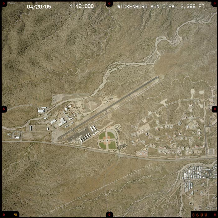
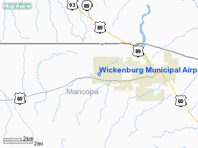
Wickenburg Municipal Airport |
Location & QuickFacts
|
FAA
Information Effective: |
2005-10-27 |
|
Airport Identifier: |
E25 |
|
Longitude/Latitude: |
112-47-54.6460W/33-58-08.1060N
-112.798513/33.968918 (Estimated) |
|
Elevation: |
2386 ft / 727.25 m (Estimated) |
|
Land: |
100 acres |
|
From nearest city: |
3
nautical miles W of Wickenburg, AZ |
|
Location: |
Maricopa County, AZ |
|
Magnetic Variation: |
13E (1985) |
Owner & Manager
|
Ownership: |
Publicly owned |
|
Owner: |
Town Of Wickenburg |
|
Address: |
155 North Tegner St Suite A
Wickenburg, AZ 85390 |
|
Phone number: |
602-506-1622 |
|
Manager: |
Jerry Stricklin |
|
Address: |
155 North Tegner St Suite A
Wickenburg, AZ 85390 |
|
Phone number: |
928-668-0512 |
Airport Operations and Facilities
|
Airport
Use: |
Open to public |
|
Wind indicator: |
Yes |
|
Segmented Circle: |
Yes |
|
Control Tower: |
No |
|
Attendance Schedule: |
ALL/ALL/0700-1900 |
|
Lighting Schedule: |
DUSK-DAWN
ACTVT MIRL RWY 05/23 - 123.0. |
|
Beacon Color: |
Clear-Green (lighted land airport) |
|
Landing fee charge: |
No |
|
Sectional chart: |
Phoenix |
|
Region: |
AWP - Western-Pacific |
|
Traffic Pattern
Alt: |
1000 ft |
|
Boundary ARTCC: |
ZAB - Albuquerque |
|
Tie-in FSS: |
PRC - Prescott |
|
FSS on Airport: |
No |
|
FSS Phone: |
928-778-7810 |
|
FSS Toll Free: |
1-800-WX-BRIEF |
|
NOTAMs Facility: |
PRC (NOTAM-d service avaliable) |
|
Federal Agreements: |
NGYS |
Airport Communications
|
CTAF: |
123.000 |
|
Unicom: |
123.000 |
Airport Services
|
Fuel
available: |
100LLA
FOR FUEL AFTER HOURS CALL 928-684-5690. |
|
Airframe
Repair: |
MINOR |
|
Power
Plant Repair: |
MINOR |
|
Bulk Oxygen: |
NONE |
Runway Information
Runway 05/23
|
Dimension: |
5050
x 75 ft / 1539.2 x 22.9 m |
|
Surface: |
ASPH,
Good Condition |
|
Weight Limit: |
Single
wheel: 16000 lbs. |
|
Edge Lights: |
Medium |
|
|
Runway 05 |
Runway 23 |
|
Elevation: |
2423.00 ft |
2379.00 ft |
|
Traffic Pattern: |
Left |
Right |
|
Markings: |
Basic, Good Condition |
Basic, Good Condition |
|
Crossing Height: |
0.00 ft |
40.00 ft |
|
Displaced threshold: |
530.00 ft |
0.00 ft |
|
VASI: |
|
4-light PAPI on left side |
|
Visual Glide Angle: |
0.00� |
3.00� |
|
Runway End Identifier: |
No |
No |
|
Centerline Lights: |
No |
No |
|
Touchdown Lights: |
No |
No |
|
Obstruction: |
15
ft hwy, 250.0 ft from runway, 125 ft right of centerline,
3:1 slope to clear
APCH RATIO 50:1 FM DSPLCD THR.
RY 05 - 5 FT FENCE 195 FT FM EOR 100 FT RIGHT. |
5
ft fence, 300.0 ft from runway, 20:1 slope to clear |
|
Radio Navigation Aids
|
ID |
Type |
Name |
Ch |
Freq |
Var |
Dist |
|
SDL |
NDB |
Scottsdale |
|
224.00 |
12E |
49.0
nm |
|
LUF |
TACAN |
Luke |
077X |
|
13E |
33.3
nm |
|
BXK |
VORTAC |
Buckeye |
043X |
110.60 |
14E |
31.0
nm |
|
DRK |
VORTAC |
Drake |
088X |
114.10 |
14E |
46.8
nm |
|
PRC |
VOT |
Prescott |
|
110.00 |
|
45.1
nm |
Based Aircraft
|
Aircraft
based on field: |
43 |
|
Single Engine Airplanes: |
37 |
|
Multi Engine Airplanes: |
4 |
|
Helicopters: |
2 |
Operational Statistics
|
Aircraft
Operations: |
50/Day |
|
Air Taxi: |
1.7% |
|
General Aviation
Local: |
54.4% |
|
General Aviation
Itinerant: |
41.1% |
|
Military: |
2.8% |
Wickenburg Municipal Airport
Address:
Maricopa County,
AZ
Tel:
602-506-1622,
928-668-0512
|
 |
(Click on the photo to
enlarge) |
Images and information placed above are from
http://www.airport-data.com/airport/E25/
http://www.dot.state.az.us/aviation/airports/airports_list.asp?FAA=E25
We thank them for the
data!
| General
Info |
| Country |
United
States |
| State |
ARIZONA
|
| FAA ID |
E25 |
| Latitude |
33-58-08.106N
|
| Longitude |
112-47-54.646W
|
| Elevation |
2386 feet
|
| Near City |
WICKENBURG
|
We don't guarantee the information is fresh and accurate. The data may be wrong or outdated.
For more up-to-date information please refer to other sources.
|
|