|
|
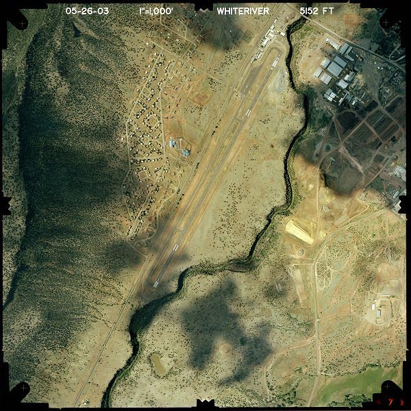
Location & QuickFacts
|
FAA
Information Effective: |
2005-10-27 |
|
Airport Identifier: |
E24 |
|
Longitude/Latitude: |
109-59-12.3570W/33-48-45.1820N
-109.986766/33.812551 (Estimated) |
|
Elevation: |
5152 ft / 1570.33 m (Estimated) |
|
Land: |
112 acres |
|
From nearest city: |
1
nautical miles SW of Whiteriver, AZ |
|
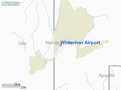
Location: |
Navajo County, AZ |
|
Magnetic Variation: |
12E (1985) |
Owner & Manager
|
Ownership: |
Publicly owned |
|
Owner: |
White Mtn Apache Tribe |
|
Address: |
P.o.box 581
Whiteriver, AZ 85941 |
|
Phone number: |
520-338-4346 |
|
Manager: |
Ken Butler |
|
Address: |
Box 560
Whiteriver, AZ 85941 |
|
Phone number: |
520-338-5321 |
Airport Operations and Facilities
|
Airport
Use: |
Open to public |
|
Wind indicator: |
Yes |
|
Segmented Circle: |
Yes |
|
Control Tower: |
No |
|
Attendance Schedule: |
APR-OCT/MON-FRI/0700-1730,NOV-MAR/MON-FRI/0800-1630 |
|
Lighting Schedule: |
DUSK-DAWN |
|
Landing fee charge: |
No |
|
Sectional chart: |
Phoenix |
|
Region: |
AWP - Western-Pacific |
|
Boundary ARTCC: |
ZAB - Albuquerque |
|
Tie-in FSS: |
PRC - Prescott |
|
FSS on Airport: |
No |
|
FSS Phone: |
928-778-7810 |
|
FSS Toll Free: |
1-800-WX-BRIEF |
|
NOTAMs Facility: |
PRC (NOTAM-d service avaliable) |
|
Federal Agreements: |
N |
Airport Communications
|
CTAF: |
122.800 |
|
Unicom: |
122.800
UNICOM MON BY USDOI DURG FIRE SEASON ONLY MAY -AUGUST. |
Airport Services
|
Airframe
Repair: |
NONE |
|
Power
Plant Repair: |
NONE |
|
Bottled Oxygen: |
NONE |
|
Bulk Oxygen: |
NONE |
Runway Information
Runway 01/19
|
Dimension: |
6288
x 75 ft / 1916.6 x 22.9 m |
|
Surface: |
ASPH,
Fair Condition |
|
Weight Limit: |
Single
wheel: 16000 lbs. |
|
Edge Lights: |
Medium |
|
|
Runway 01 |
Runway 19 |
|
Traffic Pattern: |
Right |
Left |
|
Markings: |
Nonstandard, Poor Condition
/19 NSTD MARKINGS UNDERSIZED AND FADED. |
Nonstandard, Poor Condition |
|
Displaced threshold: |
0.00 ft |
200.00 ft |
|
Runway End Identifier: |
No |
No |
|
Centerline Lights: |
No |
No |
|
Touchdown Lights: |
No |
No |
|
Radio Navigation Aids
|
ID |
Type |
Name |
Ch |
Freq |
Var |
Dist |
|
SOW |
NDB |
Show
Low |
|
206.00 |
13E |
27.4
nm |
|
GAZ |
NDB |
Globe |
|
255.00 |
13E |
43.8
nm |
Remarks
-
<
CANYON>
-
HEAVY FIRE SUPPRESSION
WORK MAR-OCT.
-
RED BALLS ON PLINE WIRES.
-
MOUNTAINS ALL QUADRANTS.
-
WATCH FOR JOGGERS ON
AIRPORT.
-
ESTABD PRIOR TO 15 MAY
1959.
Based Aircraft
|
Aircraft
based on field: |
6 |
|
Single Engine Airplanes: |
3 |
|
Multi Engine Airplanes: |
2 |
|
Helicopters: |
1 |
Operational Statistics
|
Aircraft
Operations: |
83/Week |
|
Air Taxi: |
18.6% |
|
General Aviation
Local: |
19.8% |
|
General Aviation
Itinerant: |
60.2% |
|
Military: |
1.4% |
Whiteriver Airport
Address:
Navajo County,
AZ
Tel:
520-338-4346,
520-338-5321
|
 |
(Click on the photo to
enlarge) |
Images and information placed above are from
http://www.airport-data.com/airport/E24/
http://www.dot.state.az.us/aviation/airports/airports_list.asp?FAA=E24
We thank them for the data!
| General
Info |
| Country |
United
States |
| State |
ARIZONA
|
| FAA ID |
E24 |
| Latitude |
33-48-45.182N
|
| Longitude |
109-59-12.357W
|
| Elevation |
5152 feet
|
| Near City |
WHITERIVER
|
We don't guarantee the information is fresh and accurate. The data may be wrong or outdated.
For more up-to-date information please refer to other sources.
|
|