 |
|
Location & QuickFacts
|
FAA
Information Effective: |
2005-10-27 |
|
Airport Identifier: |
AZ70 |
|
Longitude/Latitude: |
112-18-32.5950W/34-37-38.0870N
-112.309054/34.627246 (Estimated) |
|
Elevation: |
4800 ft / 1463.04 m (Estimated) |
|
Land: |
0
acres |
|
From nearest city: |
0
nautical miles N of Prescott Valley, AZ |
|
Location: |
Yavapai County, AZ |
|
Magnetic Variation: |
13E (1990) |
Owner & Manager
|
Ownership: |
Privately owned |
|
Owner: |
Thomas G. Klein |
|
Address: |
9225 E Bighorn
Prescott Valley, AZ 86314 |
|
Phone number: |
602-772-0695 |
|
Manager: |
Thomas G. Klein |
|
Address: |
9225 E Bighorn
Prescott Valley, AZ 86314 |
|
Phone number: |
602-772-0695 |
Airport Operations and Facilities
|
Airport
Use: |
Private |
|
Wind indicator: |
Yes |
|
Segmented Circle: |
No |
|
Control Tower: |
No |
|
Attendance Schedule: |
UNATNDD |
|
Lighting Schedule: |
PHONE REQ
FOR FLOODLGTS PHONE (602) 772-0695. |
|
Beacon Color: |
Clear-Green-Yellow (heliport) |
|
Sectional chart: |
Phoenix |
|
Region: |
AWP - Western-Pacific |
|
Boundary ARTCC: |
ZAB - Albuquerque |
|
Tie-in FSS: |
PRC - Prescott |
|
FSS on Airport: |
No |
|
FSS Phone: |
928-778-7810 |
|
FSS Toll Free: |
1-800-WX-BRIEF |
Runway Information
Helipad H1
|
Dimension: |
40
x 20 ft / 12.2 x 6.1 m |
|
Surface: |
CONC-TURF, |
|
|
Runway H1 |
Runway |
|
Traffic Pattern: |
Left |
Left |
|
Radio Navigation Aids
|
ID |
Type |
Name |
Ch |
Freq |
Var |
Dist |
|
PUU |
NDB |
Pulliam |
|
379.00 |
13E |
44.1
nm |
|
FLG |
VOR/DME |
Flagstaff |
085Y |
113.85 |
14E |
44.2
nm |
|
DRK |
VORTAC |
Drake |
088X |
114.10 |
14E |
9.6
nm |
|
PRC |
VOT |
Prescott |
|
110.00 |
|
5.7
nm |
Remarks
-
PROVIDED DVFR/PVT USE;
INGRESS/EGRESS 220 DEG-280 DEG; 360 DEG-050 DEG.
Based Aircraft
|
Aircraft
based on field: |
1 |
|
Helicopters: |
1 |
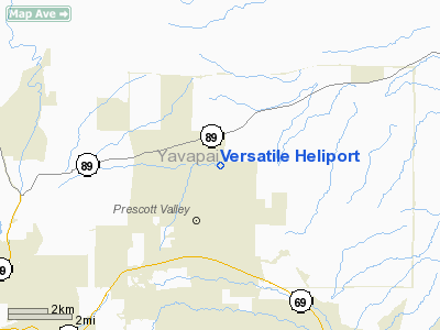
Versatile Heliport
Address:
Yavapai County,
AZ
Tel:
602-772-0695
Images and information placed above are from
http://www.airport-data.com/airport/AZ70/
We thank them for the data!
| General
Info |
| Country |
United
States |
| State |
ARIZONA
|
| FAA ID |
AZ70 |
| Latitude |
34-37-38.087N
|
| Longitude |
112-18-32.595W
|
| Elevation |
4800 feet
|
| Near City |
PRESCOTT
VALLEY |
We don't guarantee the information is fresh and accurate. The data may be wrong or outdated.
For more up-to-date information please refer to other sources.
|
|


