|
|
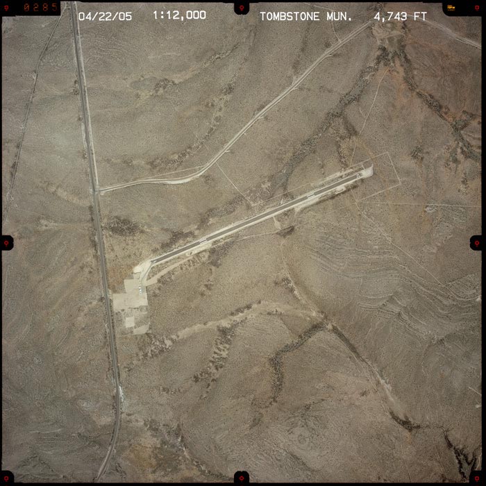
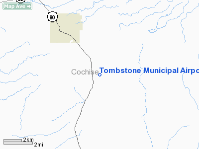
Tombstone Municipal Airport |
Location & QuickFacts
|
FAA
Information Effective: |
2005-10-27 |
|
Airport Identifier: |
P29 |
|
Longitude/Latitude: |
110-01-22.2740W/31-40-15.3300N
-110.022854/31.670925 (Estimated) |
|
Elevation: |
4743 ft / 1445.67 m (Surveyed) |
|
Land: |
144 acres |
|
From nearest city: |
3
nautical miles SE of Tombstone, AZ |
|
Location: |
Cochise County, AZ |
|
Magnetic Variation: |
12E (1985) |
Owner & Manager
|
Ownership: |
Publicly owned |
|
Owner: |
City Of Tombstone |
|
Address: |
City Hall, 315 E. Freemont St.
Tucson, AZ 85638 |
|
Phone number: |
520-457-3256 |
|
Manager: |
Sonny Adams |
|
Address: |
1581 N. Orante, Us Hwy 80
Tombstone, AZ 85638 |
|
Phone number: |
520-457-3287
OR 520-457-2202. |
Airport Operations and Facilities
|
Airport
Use: |
Open to public |
|
Wind indicator: |
Yes |
|
Segmented Circle: |
No |
|
Control Tower: |
No |
|
Attendance Schedule: |
UNATNDD |
|
Landing fee charge: |
No |
|
Sectional chart: |
Phoenix |
|
Region: |
AWP - Western-Pacific |
|
Boundary ARTCC: |
ZAB - Albuquerque |
|
Tie-in FSS: |
PRC - Prescott |
|
FSS on Airport: |
No |
|
FSS Phone: |
928-778-7810 |
|
FSS Toll Free: |
1-800-WX-BRIEF |
|
NOTAMs Facility: |
PRC (NOTAM-d service avaliable) |
|
Federal Agreements: |
1 |
Airport Communications
Airport Services
|
Airframe
Repair: |
NONE |
|
Power
Plant Repair: |
NONE |
|
Bottled Oxygen: |
NONE |
|
Bulk Oxygen: |
NONE |
Runway Information
Runway 06/24
|
Dimension: |
4610 x 65 ft /
1405.1 x 19.8 m |
|
Surface: |
DIRT,
Good Condition |
|
|
Runway 06 |
Runway 24 |
|
Elevation: |
4743.00 ft |
0.00 ft |
|
Traffic Pattern: |
Left |
Left |
|
Markings: |
None, |
None, |
|
Runway End Identifier: |
No |
No |
|
Centerline Lights: |
No |
No |
|
Touchdown Lights: |
No |
No |
|
Obstruction: |
20
ft tree, 294.0 ft from runway, 670 ft left of centerline,
4:1 slope to clear |
,
50:1 slope to clear
DRAINAGE DITCH LCTD 220 FT EAST OF RY 24, PERPENDICULAR TO
RY CNTRLN. |
|
Radio Navigation Aids
|
ID |
Type |
Name |
Ch |
Freq |
Var |
Dist |
|
DAO |
NDB |
Dragoo |
|
410.00 |
13E |
17.2
nm |
|
ENZ |
NDB |
Nogales |
|
394.00 |
12E |
44.8
nm |
|
ARH |
TACAN |
Fort
Huachuca |
053X |
|
12E |
17.0
nm |
|
FHU |
VOR |
Libby |
|
113.60 |
13E |
17.7
nm |
|
OLS |
VOR/DME |
Nogales |
019X |
108.20 |
12E |
45.0
nm |
|
DUG |
VORTAC |
Douglas |
025X |
108.80 |
13E |
24.6
nm |
|
CIE |
VORTAC |
Cochise |
105X |
115.80 |
13E |
25.6
nm |
Remarks
-
NUMEROUS TREES AND BUSHES
BTN 1 + 15 FT IN HEIGHT WITHIN PRIMARY SFC.
-
ESTABD PRIOR TO 15 MAY
1959.
Based Aircraft
|
Aircraft
based on field: |
2 |
|
Single Engine Airplanes: |
2 |
Operational Statistics
|
Aircraft
Operations: |
25/Month |
|
General Aviation
Itinerant: |
100.0% |
Tombstone Municipal
Airport
Address:
Cochise County,
AZ
Tel:
520-457-3256,
520-457-3287
|
 |
(Click on the image to enlarge) |
Images and information placed above are from
http://www.airport-data.com/airport/P29/
http://www.dot.state.az.us/aviation/airports/airports_list.asp?FAA=P29
We thank them for the data!
| General
Info |
| Country |
United
States |
| State |
ARIZONA
|
| FAA ID |
P29 |
| Latitude |
31-40-15.330N
|
| Longitude |
110-01-22.274W
|
| Elevation |
4743 feet
|
| Near City |
TOMBSTONE
|
We don't guarantee the information is fresh and accurate. The data may be wrong or outdated.
For more up-to-date information please refer to other sources.
|
|