|
|
| Temple Bar Airport |
| IATA: none – ICAO: none – FAA LID: U30 |
| Summary |
| Airport type |
Public |
| Owner |
National Park Service |
| Serves |
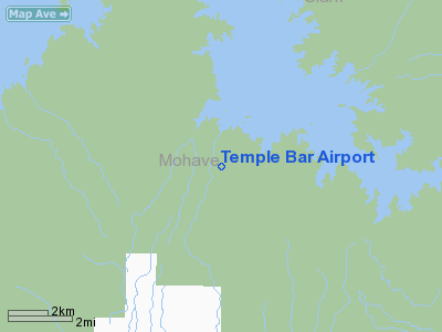
Temple Bar, Arizona |
| Elevation AMSL |
1,549 ft / 472 m |
| Coordinates |
36°01′14″N 114°20′06″W / 36.02056°N 114.335°W / 36.02056; -114.335 |
| Runways |
| Direction |
Length |
Surface |
| ft |
m |
| 18/36 |
3,500 |
1,067 |
Asphalt |
| Statistics (2010) |
| Aircraft operations |
950 |
| Source: Federal Aviation Administration |
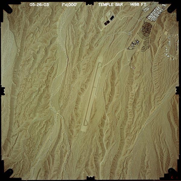
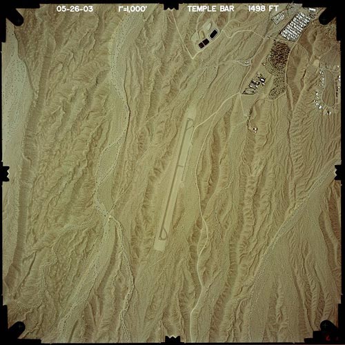
Temple Bar Airport (FAA LID: U30) is a public use airport in Mohave County, Arizona, United States. It is one nautical mile (1.85 km) southwest of the Temple Bar Marina, located on Lake Mead's Temple Basin. The airport is owned by the National Park Service.
Facilities and aircraft
Temple Bar Airport covers an area of 75 acres (30 ha) at an elevation of 1,549 feet (472 m) above mean sea level. It has one runway designated 18/36 with an asphalt surface measuring 3,500 by 50 feet (1,067 x 15 m). For the 12-month period ending April 20, 2010, the airport had 950 aircraft operations, an average of 79 per month: 74% general aviation and 26% air taxi.
The above content comes from Wikipedia and is published under free licenses – click here to read more.
Location & QuickFacts
|
FAA
Information Effective: |
2005-10-27 |
|
Airport Identifier: |
U30 |
|
Longitude/Latitude: |
114-20-06.8860W/36-01-13.9460N
-114.335246/36.020541 (Estimated) |
|
Elevation: |
1549 ft / 472.14 m (Surveyed) |
|
Land: |
75 acres |
|
From nearest city: |
1
nautical miles SW of Temple Bar, AZ |
|
Location: |
Mohave County, AZ |
|
Magnetic Variation: |
14E (1985) |
Owner & Manager
|
Ownership: |
Publicly owned |
|
Owner: |
National Park Service
LAKE MEAD NATIONAL RECREATION AREA. |
|
Address: |
601 Nevada Hwy
Boulder City, NV 89005 |
|
Phone number: |
702-293-8908 |
|
Manager: |
Bruce Lenon, Air Opns Mgr
OR PHONE 520-767-3401. |
|
Address: |
601 Nevada Hwy
Boulder City, NV 89005 |
|
Phone number: |
702-293-8908 |
Airport Operations and Facilities
|
Airport
Use: |
Open to public |
|
Wind indicator: |
Yes |
|
Segmented Circle: |
Yes |
|
Control Tower: |
No |
|
Attendance Schedule: |
UNATNDD |
|
Landing fee charge: |
No |
|
Sectional chart: |
Las Vegas |
|
Region: |
AWP - Western-Pacific |
|
Boundary ARTCC: |
ZLA - Los Angeles |
|
Tie-in FSS: |
PRC - Prescott |
|
FSS on Airport: |
No |
|
FSS Phone: |
928-778-7810 |
|
FSS Toll Free: |
1-800-WX-BRIEF |
|
NOTAMs Facility: |
PRC (NOTAM-d service avaliable) |
|
Federal Agreements: |
N |
Airport Communications
|
CTAF: |
122.800 |
|
Unicom: |
122.800
CALL 122.8 FOR TRANSPORTATION CONCESSIONAIR. |
Airport Services
|
Airframe
Repair: |
NONE |
|
Power
Plant Repair: |
NONE |
|
Bottled Oxygen: |
NONE |
|
Bulk Oxygen: |
NONE |
Runway Information
Runway 18/36
|
Dimension: |
3500 x 50 ft /
1066.8 x 15.2 m |
|
Surface: |
ASPH,
Fair Condition
RY 18/36 GRASS GROWING THROUGH NUMEROUS CRACKS. |
|
Weight Limit: |
Single
wheel: 10000 lbs. |
|
|
Runway 18 |
Runway 36 |
|
Traffic Pattern: |
Right |
Left |
|
Markings: |
Nonstandard, Fair Condition
NSTD NUMERALS ON RY 18. |
Nonstandard, Fair Condition
NSTD NUMERALS RY 36. |
|
Runway End Identifier: |
No |
No |
|
Centerline Lights: |
No |
No |
|
Touchdown Lights: |
No |
No |
|
Obstruction: |
,
50:1 slope to clear |
120
ft pline, 3000.0 ft from runway, 23:1 slope to clear
RY 36 RISING TERRAIN BEGINS AT RY END AND CONTINUES FULL LENGTH
OF APCH. |
|
Radio Navigation Aids
|
ID |
Type |
Name |
Ch |
Freq |
Var |
Dist |
|
LSV |
TACAN |
Nellis |
012X |
|
15E |
36.1
nm |
|
IGM |
VOR/DME |
Kingman |
025X |
108.80 |
15E |
49.7
nm |
|
BLD |
VORTAC |
Boulder
City |
114X |
116.70 |
15E |
25.7
nm |
|
LAS |
VORTAC |
Las
Vegas |
116X |
116.90 |
15E |
40.2
nm |
|
MMM |
VORTAC |
Mormon
Mesa |
090X |
114.30 |
16E |
45.1
nm |
|
PGS |
VORTAC |
Peach
Springs |
057X |
112.00 |
15E |
45.3
nm |
|
VGT |
VOT |
North
Las Vegas |
|
108.20 |
|
43.7
nm |
Remarks
-
LANDING IS RECOMMENDED
UPHILL TO THE SOUTH.
-
DO NOT USE TIE DOWN
AREA AS PARL TWY; BACK TAXI ON RY.
-
RY 36 TERRAIN RISES
AT CONSTANT RATE ABOVE RY.
-
BE ALERT TO PAVEMENT
WASHED OUT TO A DEPTH OF 6-8 IN UNDER EAST TIEDOWN CABLE
-
RY 18/36 20 FT BERM
180 FT WEST ALONG FULL LENGTH OF RY.
-
WILDLIFE ON & INVOF
ARPT.
Operational Statistics
|
Aircraft
Operations: |
35/Week |
|
Air Taxi: |
22.2% |
|
General Aviation
Itinerant: |
77.8% |
Temple Bar Airport
Address:
Mohave County,
AZ
Tel:
702-293-8908
|
 |
(Click on the image to enlarge) |
Images and information placed above are from
http://www.airport-data.com/airport/U30/
http://www.dot.state.az.us/aviation/airports/airports_list.asp?FAA=U30
We thank them for the data!
| General
Info |
| Country |
United
States |
| State |
ARIZONA
|
| FAA ID |
U30 |
| Latitude |
36-01-13.946N
|
| Longitude |
114-20-06.886W
|
| Elevation |
1549 feet
|
| Near City |
TEMPLE
BAR |
We don't guarantee the information is fresh and accurate. The data may be wrong or outdated.
For more up-to-date information please refer to other sources.
|
|