|
|
| Taylor Airport |
| IATA: TYZ – ICAO: KTYL – FAA LID: TYL |
| Summary |
| Airport type |
Public |
| Owner |
Town of Taylor |
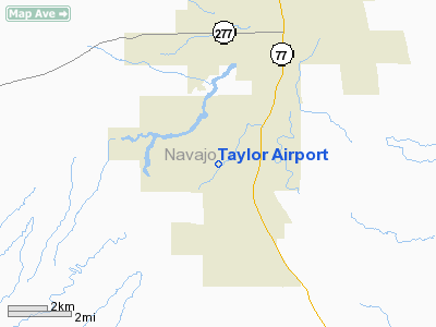
| Location |
Taylor, Arizona |
| Elevation AMSL |
5,820 ft / 1,774 m |
| Coordinates |
34°27′10″N 110°06′53″W / 34.45278°N 110.11472°W / 34.45278; -110.11472 |
| Runways |
| Direction |
Length |
Surface |
| ft |
m |
| 3/21 |
7,000 |
2,134 |
Asphalt |
| Statistics (2006) |
| Aircraft operations |
2,700 |
| Source: Federal Aviation Administration |
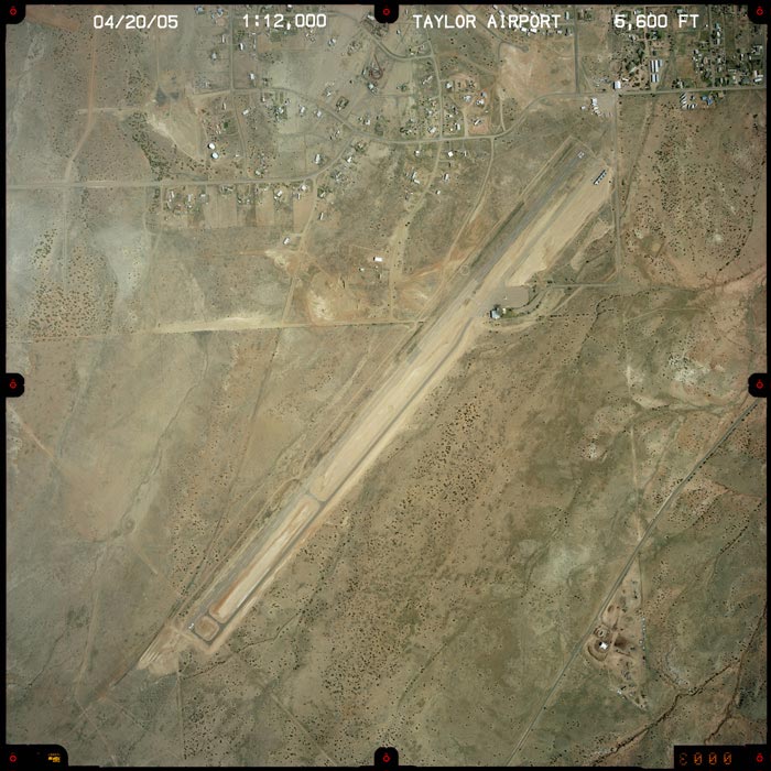
Taylor Airport (IATA: TYZ, ICAO: KTYL, FAA LID: TYL), also known as Taylor Municipal Airport, is a public airport located two miles (3 km) southwest of the central business district of Taylor, a city in Navajo County, Arizona, United States. The airport covers 102 acres (41 ha) and has one runway.
Although most U.S. airports use the same three-letter location identifier for the FAA and IATA, Taylor Airport is assigned TYL by the FAA and TYZ by the IATA (which assigned TYL to Capitan Montes Airport in Talara, Perú).
The above content comes from Wikipedia and is published under free licenses – click here to read more.
Location & QuickFacts
|
FAA
Information Effective: |
2005-10-27 |
|
Airport Identifier: |
TYL |
|
Longitude/Latitude: |
110-06-53.3000W/34-27-10.2000N
-110.114806/34.452833 (Estimated) |
|
Elevation: |
5820 ft / 1773.94 m (Surveyed) |
|
Land: |
102 acres |
|
From nearest city: |
2
nautical miles SW of Taylor, AZ |
|
Location: |
Navajo County, AZ |
|
Magnetic Variation: |
12E (2000) |
Owner & Manager
|
Ownership: |
Publicly owned |
|
Owner: |
Town Of Taylor |
|
Address: |
Box 158
Taylor, AZ 85939 |
|
Phone number: |
520-536-7366 |
|
Manager: |
Richard Prior |
|
Address: |
Box 158
Taylor, AZ 85939 |
|
Phone number: |
928-536-7366 |
Airport Operations and Facilities
|
Airport
Use: |
Open to public |
|
Wind indicator: |
Yes |
|
Segmented Circle: |
Yes |
|
Control Tower: |
No |
|
Attendance Schedule: |
ALL/MON-SAT/DALGT |
|
Lighting Schedule: |
DUSK-DAWN
ACTVT MIRL RY 03/21 - CTAF. |
|
Beacon Color: |
Clear-Green (lighted land airport) |
|
Landing fee charge: |
No |
|
Sectional chart: |
Phoenix |
|
Region: |
AWP - Western-Pacific |
|
Boundary ARTCC: |
ZAB - Albuquerque |
|
Tie-in FSS: |
PRC - Prescott |
|
FSS on Airport: |
No |
|
FSS Phone: |
928-778-7810 |
|
FSS Toll Free: |
1-800-WX-BRIEF |
|
NOTAMs Facility: |
PRC (NOTAM-d service avaliable) |
|
Federal Agreements: |
NGY |
Airport Communications
|
CTAF: |
122.700 |
|
Unicom: |
122.700 |
Airport Services
|
Fuel
available: |
100LL |
|
Airframe
Repair: |
MINOR |
|
Power
Plant Repair: |
MINOR |
|
Bottled Oxygen: |
NONE |
Runway Information
Runway 03/21
|
Dimension: |
7200 x 75 ft /
2194.6 x 22.9 m |
|
Surface: |
ASPH,
Good Condition |
|
Edge Lights: |
Medium |
|
|
Runway 03 |
Runway 21 |
|
Longitude: |
110-07-21.6100W |
110-06-25.1000W |
|
Latitude: |
34-26-43.4400N |
34-27-37.1300N |
|
Elevation: |
5820.00 ft |
5715.00 ft |
|
Alignment: |
41 |
127 |
|
Traffic Pattern: |
Left |
Left |
|
Markings: |
Basic, Good Condition |
Basic, Good Condition |
|
Crossing Height: |
36.00 ft |
20.00 ft |
|
VASI: |
2-light PAPI on left side |
2-light PAPI on left side |
|
Visual Glide Angle: |
4.00� |
3.00� |
|
Runway End Identifier: |
Yes |
Yes |
|
Radio Navigation Aids
|
ID |
Type |
Name |
Ch |
Freq |
Var |
Dist |
|
SOW |
NDB |
Show
Low |
|
206.00 |
13E |
12.3
nm |
|
SJN |
VORTAC |
St
Johns |
070X |
112.30 |
12E |
48.2
nm |
|
INW |
VORTAC |
Winslow |
073X |
112.60 |
14E |
49.7
nm |
Remarks
-
MILITARY TFC NEAR AIRPORT.
-
+75 FT TREES 450 FT
EAST OF RY CNTRLN.
Based Aircraft
|
Aircraft
based on field: |
7 |
|
Single Engine Airplanes: |
7 |
Operational Statistics
|
Aircraft
Operations: |
93/Week |
|
Air Taxi: |
22.9% |
|
General Aviation
Local: |
62.5% |
|
General Aviation
Itinerant: |
14.6% |
Taylor
Airport
Address:
Navajo County,
AZ
Tel:
520-536-7366,
928-536-7366
|
 |
(Click on the image to enlarge) |
Images and information placed above are from
http://www.airport-data.com/airport/TYL/
http://www.dot.state.az.us/aviation/airports/airports_list.asp?FAA=TYL
We thank them for the data!
| General
Info |
| Country |
United
States |
| State |
ARIZONA
|
| FAA ID |
TYL |
| Latitude |
34-27-10.200N
|
| Longitude |
110-06-53.300W
|
| Elevation |
5820 feet
|
| Near City |
TAYLOR
|
We don't guarantee the information is fresh and accurate. The data may be wrong or outdated.
For more up-to-date information please refer to other sources.
|
|