|
|
Superior Municipal Airport |
Location & QuickFacts
|
FAA
Information Effective: |
2005-10-27 |
|
Airport Identifier: |
E81 |
|
Longitude/Latitude: |
111-07-37.4340W/33-16-40.2020N
-111.127065/33.277834 (Estimated) |
|
Elevation: |
2646 ft / 806.50 m (Estimated) |
|
Land: |
265 acres |
|
From nearest city: |
2
nautical miles SW of Superior, AZ |
|
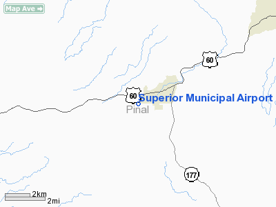
Location: |
Pinal County, AZ |
|
Magnetic Variation: |
12E (1985) |
Owner & Manager
|
Ownership: |
Publicly owned |
|
Owner: |
Town Of Superior |
|
Address: |
734 Main Street
Superior, AZ 85273 |
|
Phone number: |
520-689-2484 |
|
Manager: |
Arthur Derham |
|
Address: |
Box 1246
Apache Junction, AZ 85217 |
|
Phone number: |
480-982-0227 |
Airport Operations and Facilities
|
Airport
Use: |
Open to public |
|
Wind indicator: |
Yes |
|
Segmented Circle: |
No |
|
Control Tower: |
No |
|
Attendance Schedule: |
UNATNDD |
|
Landing fee charge: |
No |
|
Sectional chart: |
Phoenix |
|
Region: |
AWP - Western-Pacific |
|
Boundary ARTCC: |
ZAB - Albuquerque |
|
Tie-in FSS: |
PRC - Prescott |
|
FSS on Airport: |
No |
|
FSS Phone: |
928-778-7810 |
|
FSS Toll Free: |
1-800-WX-BRIEF |
|
NOTAMs Facility: |
PRC (NOTAM-d service avaliable) |
|
Federal Agreements: |
S |
Airport Communications
Airport Services
|
Airframe
Repair: |
NONE |
|
Power
Plant Repair: |
NONE |
|
Bottled Oxygen: |
NONE |
|
Bulk Oxygen: |
NONE |
Runway Information
Runway 04/22
|
Dimension: |
3500 x 75 ft /
1066.8 x 22.9 m |
|
Surface: |
DIRT,
Poor Condition
RY 04/22 LOOSE GRAVEL & WEEDS ON RY SFC. |
|
|
Runway 04 |
Runway 22 |
|
Traffic Pattern: |
Left |
Left |
|
Markings: |
None,
RY 04/22 THLDS & EDGES MKD WITH YELLOW TIRES 200 FT APART. |
None, |
|
Runway End Identifier: |
No |
No |
|
Centerline Lights: |
No |
No |
|
Touchdown Lights: |
No |
No |
|
Obstruction: |
8
ft brush, 70.0 ft from runway, 35 ft right of centerline,
3:1 slope to clear |
4
ft tree, 130.0 ft from runway, 30 ft right of centerline,
32:1 slope to clear |
|
Radio Navigation Aids
|
ID |
Type |
Name |
Ch |
Freq |
Var |
Dist |
|
GAZ |
NDB |
Globe |
|
255.00 |
13E |
23.6
nm |
|
FFZ |
NDB |
Falcon
Field |
|
281.00 |
12E |
32.4
nm |
|
CHD |
NDB |
Chandler |
|
407.00 |
12E |
34.2
nm |
|
SDL |
NDB |
Scottsdale |
|
224.00 |
12E |
44.5
nm |
|
IWA |
VORTAC |
Willie |
080X |
113.30 |
13E |
26.4
nm |
|
PXR |
VORTAC |
Phoenix |
103X |
115.60 |
12E |
43.3
nm |
|
TFD |
VORTAC |
Stanfield |
095X |
114.80 |
12E |
45.9
nm |
|
PHX |
VOT |
Phoenix
Sky Harbor |
|
109.00 |
|
45.2
nm |
Remarks
-
OBSTNS BRUSH NE RWY;
TERRAIN & SMELTER STACKS NE; HILLS & MTN SSW THRU SW OF ARPT.
-
AMGR RECOMMENDS LNDG
UPHILL TO THE NE.
-
ARPT LEASED TO SUPERSTITION
FOOT HILLS CORP.
-
RY 04/22 HAS BRUSH AND
TREES TO A HEIGHT OF 12 FEET ON BOTH SIDES OF THE RY.
-
(ARPT STATUS) ARPT CLSD
INDEFLY.
-
ESTABD PRIOR TO 5/15/59.
Operational Statistics
|
Aircraft
Operations: |
34/Month |
|
General Aviation
Local: |
50.0% |
|
General Aviation
Itinerant: |
50.0% |
Superior Municipal Airport
Address:
Pinal County,
AZ
Tel:
520-689-2484,
480-982-0227
|
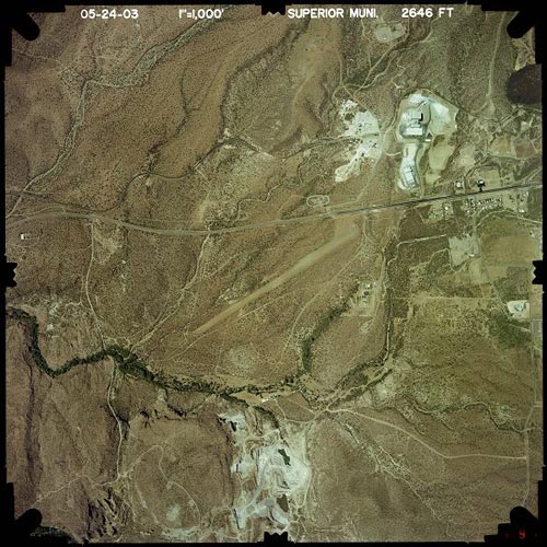 |
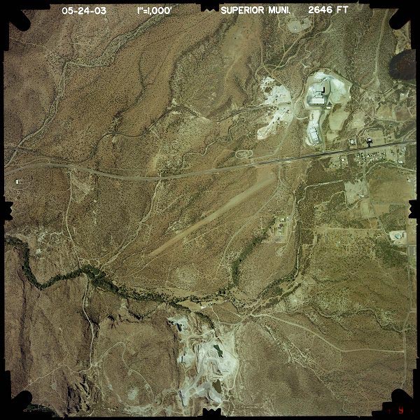
(Click on the image to enlarge) |
Images and information placed above are from
http://www.airport-data.com/airport/E81/
http://www.dot.state.az.us/aviation/airports/airports_list.asp?FAA=E81
We thank them for the data!
| General
Info |
| Country |
United
States |
| State |
ARIZONA
|
| FAA ID |
E81 |
| Latitude |
33-16-40.202N
|
| Longitude |
111-07-37.434W
|
| Elevation |
2646 feet
|
| Near City |
SUPERIOR
|
We don't guarantee the information is fresh and accurate. The data may be wrong or outdated.
For more up-to-date information please refer to other sources.
|
|