|
|
| Sun Valley Airport |
 |
| IATA: none – ICAO: none – FAA LID: A20 |
| Summary |
| Airport type |
Public |
| Owner |
Corrigan Nav Strat LLC & PTR LLC |
| Serves |
Bullhead City, Arizona |
| Elevation AMSL |
725 ft / 221 m |
| Coordinates |
35°00′20″N 114°33′54″W / 35.00556°N 114.565°W / 35.00556; -114.565 |
| Website |
BullheadCityAirport.com |
| Runways |
| Direction |
Length |
Surface |
| ft |
m |
| 18/36 |
3,700 |
1,128 |
Asphalt |
| Statistics (2007) |
| Aircraft operations |
14,400 |
| Based aircraft |
22 |
| Source: Federal Aviation Administration |
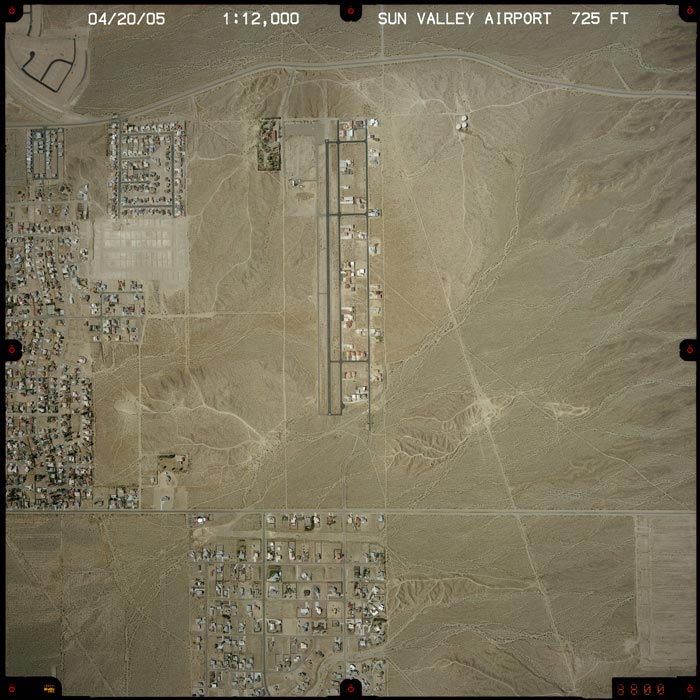
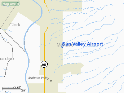
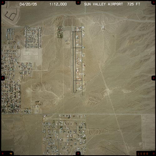
Sun Valley Airport (FAA LID: A20) is a privately-owned public-use airport and residential airpark located seven miles (11 km) south of the central business district of Bullhead City, in Mohave County, Arizona, United States.
Facilities and aircraft
Sun Valley Airport covers an area of 100 acres (40 ha) which contains one [[as[halt]] paved runway (18/36) measuring 3,700 x 42 ft (1,128 x 13 m). For the 12-month period ending May 2, 2007, the airport had 14,400 general aviation aircraft operations, an average of 39 per day. At that time there were 22 aircraft based at this airport: 91% single-engine and 9% multi-engine.
The above content comes from Wikipedia and is published under free licenses – click here to read more.
Location & QuickFacts
|
FAA
Information Effective: |
2005-10-27 |
|
Airport Identifier: |
A20 |
|
Longitude/Latitude: |
114-33-47.8690W/35-00-45.0060N
-114.563297/35.012502 (Estimated) |
|
Elevation: |
725 ft / 220.98 m (Estimated) |
|
Land: |
50 acres |
|
From nearest city: |
7
nautical miles S of Bullhead City, AZ |
|
Location: |
Mohave County, AZ |
|
Magnetic Variation: |
14E (1985) |
Owner & Manager
|
Ownership: |
Privately owned |
|
Owner: |
Mohave Sun Valley Co
MILAN ZIEMAN |
|
Address: |
5050 Bison Ave
Bullhead City, AZ 86430 |
|
Phone number: |
702-458-8897 |
|
Manager: |
Jean Doyle |
|
Address: |
5050 Bison Ave
Bullhead City, AZ 86430 |
|
Phone number: |
928-768-7765 |
Airport Operations and Facilities
|
Airport
Use: |
Private |
|
Wind indicator: |
Yes |
|
Segmented Circle: |
Yes |
|
Control Tower: |
No |
|
Attendance Schedule: |
ALL/ALL/IREG |
|
Lighting Schedule: |
RDO-CTL
ACTVT LIRL RY 18/36 - CTAF |
|
Landing fee charge: |
No |
|
Sectional chart: |
Phoenix |
|
Region: |
AWP - Western-Pacific |
|
Boundary ARTCC: |
ZLA - Los Angeles |
|
Tie-in FSS: |
PRC - Prescott |
|
FSS on Airport: |
No |
|
FSS Phone: |
928-778-7810 |
|
FSS Toll Free: |
1-800-WX-BRIEF |
|
NOTAMs Facility: |
PRC (NOTAM-d service avaliable) |
Airport Communications
|
CTAF: |
122.975 |
|
Unicom: |
122.975 |
Airport Services
|
Fuel
available: |
100LL |
|
Airframe
Repair: |
MINOR |
|
Power
Plant Repair: |
MINOR |
Runway Information
Runway 18/36
|
Dimension: |
3700 x 42 ft /
1127.8 x 12.8 m |
|
Surface: |
ASPH,
Fair Condition |
|
Edge Lights: |
Low
LIRL RY 18/36 OTS INDEFLY. |
|
|
Runway 18 |
Runway 36 |
|
Traffic Pattern: |
Left |
Right |
|
Markings: |
Nonstandard, Good Condition
/36 NSTD MARKINGS; NARROW CNTRLN STRIPES. |
Nonstandard, Good Condition |
|
Obstruction: |
10
ft road, 265.0 ft from runway, 6:1 slope to clear |
,
50:1 slope to clear
+6 FT BRUSH, 115 FT FM EOR 45 FT LEFT. |
|
Radio Navigation Aids
|
ID |
Type |
Name |
Ch |
Freq |
Var |
Dist |
|
IGM |
VOR/DME |
Kingman |
025X |
108.80 |
15E |
34.3
nm |
|
EED |
VORTAC |
Needles |
099X |
115.20 |
15E |
15.5
nm |
|
GFS |
VORTAC |
Goffs |
091X |
114.40 |
15E |
31.0
nm |
Remarks
-
SHALLOW DITCH 25 FT
IN LENGTH LOCATED 40 FT R OF RY 36.
-
ACCESS TO ARPT RQRS
A 4 DIGIT CODE AT GATE ENTRANCE. CALL AMGR TO OBTAIN CODE PRIOR TO ENTRY.
-
VFR ONLY.
Based Aircraft
|
Aircraft
based on field: |
11 |
|
Single Engine Airplanes: |
11 |
Operational Statistics
|
Aircraft
Operations: |
15/Week |
|
General Aviation
Local: |
100.0% |
Sun Valley Airport
Address:
Mohave County,
AZ
Tel:
702-458-8897,
928-768-7765
|
 |
(Click on the image to enlarge) |
Images and information placed above are from
http://www.airport-data.com/airport/A20/
http://www.dot.state.az.us/aviation/airports/airports_list.asp?FAA=A20
We thank them for the data!
| General
Info |
| Country |
United
States |
| State |
ARIZONA
|
| FAA ID |
A20 |
| Latitude |
35-00-45.006N
|
| Longitude |
114-33-47.869W
|
| Elevation |
725 feet
|
| Near City |
BULLHEAD
CITY |
We don't guarantee the information is fresh and accurate. The data may be wrong or outdated.
For more up-to-date information please refer to other sources.
|
|