|
 |
|
||||
|
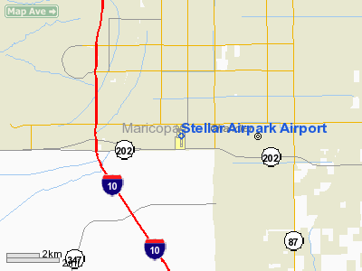
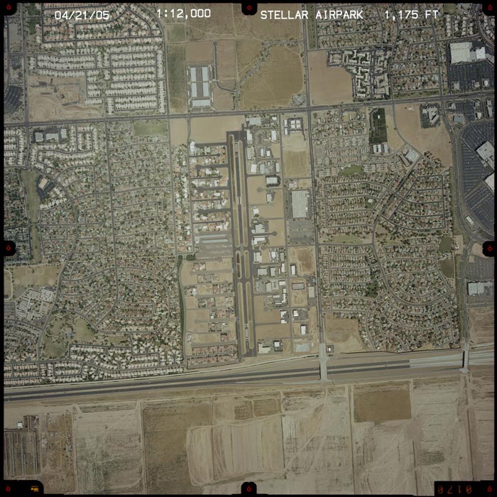
Stellar Airpark (IATA: SLJ, FAA LID: P19) is a public-use airport and residential airpark located three miles (5 km) west of the central business district of Chandler, a city in Maricopa County, Arizona, United States. It is privately-owned by the Stellar Runway Utilizers Association, Inc. Facilities and aircraftStellar Airpark covers an area of 200 acres (81 ha) which contains one asphalt paved runway (17/35) measuring 3,913 x 60 ft (1,193 x 18 m). For the 12-month period ending July 31, 2005, the airport had 39,000 aircraft operations, an average of 106 per day, all of which were general aviation. There are 152 aircraft based at this airport: 88% single engine, 7% multi-engine, 3% jet aircraft, 2% helicopters and 1% ultralight. The above content comes from Wikipedia and is published under free licenses – click here to read more.
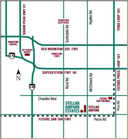
Location Located south of Chandler Boulevard and west of McClintock Road, only one mile west of the Pima/Loop 101 Freeway, three miles east of the 1-10 Freeway, and immediately north of the future San Tan Freeway. Just east is the new one million square foot Wescor San Tan shopping and entertainment mall. No other airpark community puts you within easy reach
of so many attractions. Downtown Phoenix with its sports and entertainment
is just 20 minutes away, Sky Harbor and downtown Tempe within 15 minutes
and downtown Scottsdale within 20. 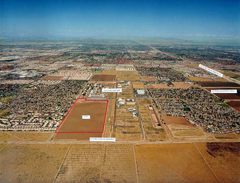
Location & QuickFacts
|
|||||||||||||||||||||||||||||||||||||||||||||||||||||||||||||||||||||||||||||||||||||||||||||||||||||||||||||||||||||||||||||||||||||||||||||||||||||||||||||||||||||||||||||||||||||||||||||||||||||||||||||||||||||||||||||||||||||||||||||||||||||||||||||||||||||||||||||||||||||||||||||||||||||||||||||||||||||||||||||||||||||||||||||||||||||||
|
Ownership: |
Privately owned |
| Owner: |
Stellar Runway Utilizers Assn, Inc. |
| Address: |
4303 West Jupiter Way |
| Phone number: |
480-961-1502 |
| Manager: |
Mike Kramer |
| Address: |
4303 West Jupiter Way |
| Phone number: |
480-961-1502 |
|
Airport Use: |
Private |
| Wind indicator: |
Yes |
| Segmented Circle: |
No |
| Control Tower: |
No |
| Attendance Schedule: |
UNATNDD |
| Lighting Schedule: |
DUSK-DAWN |
| Beacon Color: |
Clear-Green (lighted land airport) |
| Landing fee charge: |
No |
| Sectional chart: |
Phoenix |
| Region: |
AWP - Western-Pacific |
| Traffic Pattern Alt: |
823 ft |
| Boundary ARTCC: |
ZAB - Albuquerque |
| Tie-in FSS: |
PRC - Prescott |
| FSS on Airport: |
No |
| FSS Phone: |
928-778-7810 |
| FSS Toll Free: |
1-800-WX-BRIEF |
| NOTAMs Facility: |
PRC (NOTAM-d service avaliable) |
|
CTAF: |
122.900 |
|
Fuel available: |
100LLA |
|
Airframe Repair: |
MINOR |
|
Power Plant Repair: |
MINOR |
| Bulk Oxygen: |
NONE |
|
Dimension: |
3913 x 60 ft / 1192.7 x 18.3 m |
|||||||||||||||||||||||||||||||||||||||||||||
| Surface: |
ASPH, Good Condition |
|||||||||||||||||||||||||||||||||||||||||||||
| Edge Lights: |
Medium |
|||||||||||||||||||||||||||||||||||||||||||||
|
||||||||||||||||||||||||||||||||||||||||||||||
|
ID |
Type |
Name |
Ch |
Freq |
Var |
Dist |
| CHD |
NDB |
Chandler |
|
407.00 |
12E |
5.7 nm |
| FFZ |
NDB |
Falcon Field |
|
281.00 |
12E |
13.4 nm |
| SDL |
NDB |
Scottsdale |
|
224.00 |
12E |
19.9 nm |
| LUF |
TACAN |
Luke |
077X |
|
13E |
27.4 nm |
| PXR |
VORTAC |
Phoenix |
103X |
115.60 |
12E |
8.5 nm |
| IWA |
VORTAC |
Willie |
080X |
113.30 |
13E |
13.3 nm |
| TFD |
VORTAC |
Stanfield |
095X |
114.80 |
12E |
24.8 nm |
| GBN |
VORTAC |
Gila Bend |
113X |
116.60 |
14E |
43.4 nm |
| BXK |
VORTAC |
Buckeye |
043X |
110.60 |
14E |
46.6 nm |
| PHX |
VOT |
Phoenix Sky Harbor |
|
109.00 |
|
9.4 nm |
|
Aircraft based on field: |
152 |
| Single Engine Airplanes: |
133 |
| Multi Engine Airplanes: |
6 |
| Jet Engine Airplanes: |
2 |
| Helicopters: |
10 |
| Gliders: |
1 |
|
Aircraft Operations: |
113/Day |
| General Aviation Local: |
75.6% |
| General Aviation Itinerant: |
24.4% |
| Military: |
0.0% |
Stellar Airpark Airport
Address: South of Chandler Blvd.
between Rural & McClintock
Phone: (480) 991-9111
Email: dgannon@mark-taylor.com
URL: http://www.stellarairpark.com/AirPark_old/airpark_new/Home.asp
 |
(Click on the image to enlarge) |
http://www.airport-data.com/airport/P19/
http://www.dot.state.az.us/aviation/airports/airports_list.asp?FAA=P19
http://www.stellarairpark.com/AirPark_old/airpark_new/Home.asp
We thank them for the data!
| General Info | |
|---|---|
| Country | United States |
| State | ARIZONA |
| FAA ID | P19 |
| Latitude | 33-17-54.700N |
| Longitude | 111-54-56.800W |
| Elevation | 1177 feet |
| Near City | CHANDLER |

 |
|
Copyright 2004-2026 © by Airports-Worldwide.com, Vyshenskoho st. 36, Lviv 79010, Ukraine Legal Disclaimer |