|
|
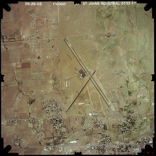
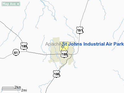
St Johns Industrial Air Park Airport |
Location & QuickFacts
|
FAA
Information Effective: |
2005-10-27 |
|
Airport Identifier: |
SJN |
|
Longitude/Latitude: |
109-22-43.5000W/34-31-06.8000N
-109.378750/34.518556 (Estimated) |
|
Elevation: |
5736 ft / 1748.33 m (Surveyed) |
|
Land: |
112 acres |
|
From nearest city: |
9
nautical miles N of St Johns, AZ |
|
Location: |
Apache County, AZ |
|
Magnetic Variation: |
12E (1985) |
Owner & Manager
|
Ownership: |
Publicly owned |
|
Owner: |
City Of St. Johns |
|
Address: |
P.o. Box 455
St. Johns, AZ 85936 |
|
Phone
number: |
520-337-4517 |
|
Manager: |
Gary Liston |
|
Address: |
P.o. Box 455
St. Johns, AZ 85936 |
|
Phone
number: |
520-337-4254 |
Airport Operations and Facilities
|
Airport
Use: |
Open to public |
|
Wind indicator: |
Yes |
|
Segmented Circle: |
Yes |
|
Control Tower: |
No |
|
Attendance Schedule: |
ALL/ALL/ALL |
|
Lighting Schedule: |
DUSK-DAWN |
|
Beacon Color: |
Clear-Green (lighted land airport) |
|
Sectional chart: |
Phoenix |
|
Region: |
AWP - Western-Pacific |
|
Traffic Pattern
Alt: |
1000 ft |
|
Boundary ARTCC: |
ZAB - Albuquerque |
|
Tie-in FSS: |
PRC - Prescott |
|
FSS on Airport: |
No |
|
FSS Phone: |
928-778-7810 |
|
FSS Toll Free: |
1-800-WX-BRIEF |
|
NOTAMs Facility: |
SJN (NOTAM-d service avaliable) |
|
Federal Agreements: |
NGY |
Airport Communications
|
CTAF: |
122.800 |
|
Unicom: |
122.800 |
Airport Services
|
Fuel
available: |
100LLA MOGAS |
|
Airframe
Repair: |
MINOR |
|
Power
Plant Repair: |
MINOR |
|
Bottled Oxygen: |
NONE |
|
Bulk Oxygen: |
NONE |
Runway Information
Runway 03/21
|
Dimension: |
3400 x 60 ft /
1036.3 x 18.3 m
RY 03 200 FT GRAVEL CLEAR AREA ON S END OF RY. |
|
Surface: |
ASPH,
Good Condition |
|
Weight Limit: |
Single
wheel: 55000 lbs. |
|
|
Runway 03 |
Runway 21 |
|
Longitude: |
109-22-59.4930W |
109-22-35.0660W |
|
Latitude: |
34-30-45.5910N |
34-31-12.4530N |
|
Elevation: |
5727.00 ft |
5735.00 ft |
|
Alignment: |
37 |
127 |
|
Traffic Pattern: |
Left |
Left |
|
Markings: |
Basic, Good Condition |
Basic, Good Condition |
|
Displaced threshold: |
190.00 ft |
0.00 ft |
|
Runway End Identifier: |
No |
No |
|
Centerline Lights: |
No |
No |
|
Touchdown Lights: |
No |
No |
|
Obstruction: |
45
ft tree, 385.0 ft from runway, 2:1 slope to clear
APCH RATIO 12:1 TO DSPLCD THR. |
,
50:1 slope to clear |
|
Runway 14/32
|
Dimension: |
5322 x 75 ft /
1622.1 x 22.9 m
RY 03 200 FT GRAVEL CLEAR AREA ON S END OF RY. |
|
Surface: |
ASPH,
Good Condition |
|
Weight Limit: |
Single
wheel: 90000 lbs. |
|
Edge Lights: |
Medium |
|
|
Runway 14 |
Runway 32 |
|
Longitude: |
109-22-57.8010W |
109-22-24.4260W |
|
Latitude: |
34-31-34.2310N |
34-30-49.4350N |
|
Elevation: |
5734.00 ft |
5736.00 ft |
|
Alignment: |
127 |
127 |
|
Traffic Pattern: |
Left |
Left |
|
Markings: |
Basic, Good Condition |
Non-precision instrument, Good Condition |
|
Crossing Height: |
40.00 ft |
40.00 ft |
|
Displaced threshold: |
189.00 ft |
0.00 ft |
|
VASI: |
2-light PAPI on left side |
2-light PAPI on right side |
|
Visual Glide Angle: |
3.00� |
3.00� |
|
Runway End Identifier: |
No |
Yes |
|
Centerline Lights: |
No |
No |
|
Touchdown Lights: |
No |
No |
|
Obstruction: |
33
ft pole, 1050.0 ft from runway, 25:1 slope to clear
APCH RATIO 37:1 TO DSPLCD THR.
+15 FT ROAD (DEPRESSED -6 FT); 9 FT ROAD 10 FT FROM RY END
& 0B. |
12
ft bldg, 363.0 ft from runway, 100 ft left of centerline,
13:1 slope to clear |
|
Radio Navigation Aids
|
ID |
Type |
Name |
Ch |
Freq |
Var |
Dist |
|
SOW |
NDB |
Show
Low |
|
206.00 |
13E |
34.7
nm |
|
SJN |
VORTAC |
St
Johns |
070X |
112.30 |
12E |
13.0
nm |
|
ZUN |
VORTAC |
Zuni |
081X |
113.40 |
14E |
29.1
nm |
Remarks
-
MILITARY TFC NEAR AIRPORT.
-
RY 03/21 HAS WHITE REFLECTORS
ENTIRE LENGTH OF RY ON BOTH SIDES.
-
RY 21 THLD LGTS OTS
INDEFLY. NON-STD THLD REFLECTORS IN PLACE.
-
TWY PARALLEL TO RY 14/32
HAS REFLECTORS ENTIRE LENGTH OF TWY ON BOTH SIDES.
Based Aircraft
|
Aircraft
based on field: |
15 |
|
Single Engine Airplanes: |
15 |
Operational Statistics
|
Aircraft
Operations: |
289/Week |
|
Air Taxi: |
26.7% |
|
General Aviation
Local: |
20.0% |
|
General Aviation
Itinerant: |
46.7% |
|
Military: |
6.7% |
St Johns Industrial
Air Park Airport
Address:
Apache County,
AZ
Tel:
520-337-4517,
520-337-4254
|
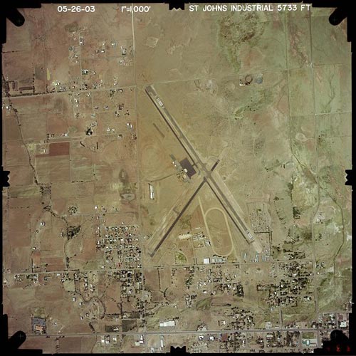 |
(Click on the image to enlarge) |
Images and information placed above are from
http://www.airport-data.com/airport/SJN/
http://www.dot.state.az.us/aviation/airports/airports_list.asp?FAA=SJN
We thank them for the data!
| General
Info |
| Country |
United
States |
| State |
ARIZONA
|
| FAA ID |
SJN |
| Latitude |
34-31-06.800N
|
| Longitude |
109-22-43.500W
|
| Elevation |
5736 feet
|
| Near City |
ST JOHNS
|
We don't guarantee the information is fresh and accurate. The data may be wrong or outdated.
For more up-to-date information please refer to other sources.
|
|