 |
|
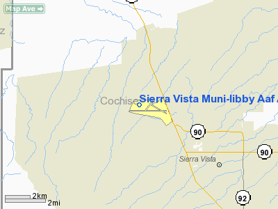
Sierra Vista Municipal-libby Army Airfield Airport |
Sierra Vista Municipal Airport
Libby Army Airfield |
 |
| IATA: FHU – ICAO: KFHU – FAA LID: FHU |
| Summary |
| Airport type |
Public / Military |
| Operator |
City of Sierra Vista and
United States Army |
| Serves |
Sierra Vista, Arizona |
| Location |
Fort Huachuca |
| Elevation AMSL |
4,719 ft / 1,438 m |
| Coordinates |
31°35′18″N 110°20′40″W / 31.58833°N 110.34444°W / 31.58833; -110.34444 |
| Runways |
| Direction |
Length |
Surface |
| ft |
m |
| 8/26 |
12,001 |
3,658 |
Concrete |
| 12/30 |
5,366 |
1,636 |
Asphalt/Concrete |
| 3/21 |
4,285 |
1,306 |
Asphalt/Concrete |
| Helipads |
| Number |
Length |
Surface |
| ft |
m |
| H1 |
40 |
12 |
Asphalt |
| Statistics (2006) |
| Aircraft operations |
157,184 |
| Based aircraft |
118 |
| Source: Federal Aviation Administration |
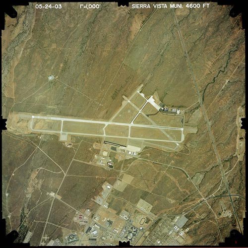
Sierra Vista Municipal Airport (IATA: FHU, ICAO: KFHU, FAA LID: FHU), a joint-use airport which shares facilities with Libby Army Airfield, is located on Fort Huachuca in Sierra Vista, a city in Cochise County, Arizona, United States. The airport has three runways and one helipad. It is mostly used for military aviation for the surrounding military base.
As per Federal Aviation Administration records, the airport had 1,304 passenger boardings (enplanements) in calendar year 2005 and 2,041 enplanements in 2006. According to the FAA's National Plan of Integrated Airport Systems for 2007–2011, Sierra Vista is a general aviation airport (the commercial service category requires at least 2,500 passenger boardings per year). Scheduled commercial service by Great Lakes Airlines to Phoenix Sky Harbor International Airport ended on February 28, 2007.
Facilities and aircraft
Sierra Vista Municipal/Libby Army Airfield has three runways and one helipad:
- Runway 8/26: 12,001 x 150 ft (3,658 x 46 m), Surface: Concrete
- Runway 12/30: 5,366 x 100 ft (1,636 x 30 m), Surface: Asphalt/Concrete
- Runway 3/21: 4,285 x 75 ft (1,306 x 23 m), Surface: Asphalt/Concrete
- Helipad H1: 40 x 40 ft (12 x 12 m), Surface: Asphalt
For the 12-month period ending December 31, 2006, the airport had 157,184 aircraft operations, an average of 430 per day: 74% military, 24% general aviation, 1% scheduled commercial and <1% air taxi. There are 118 aircraft based at this airport: 59% single engine, 24% military, 7% multi engine, 7% helicopters and 3% ultralights.
The above content comes from Wikipedia and is published under free licenses – click here to read more.
Location & QuickFacts
|
FAA
Information Effective: |
2005-10-27 |
|
Airport Identifier: |
FHU |
|
Longitude/Latitude: |
110-20-39.8000W/31-35-18.5000N
-110.344389/31.588472 (Estimated) |
|
Elevation: |
4719 ft / 1438.35 m (Surveyed) |
|
Land: |
0
acres |
|
From nearest city: |
3
nautical miles N of Fort Huachuca Sierra Vista, AZ |
|
Location: |
Cochise County, AZ |
|
Magnetic Variation: |
13E (1965) |
Owner & Manager
|
Ownership: |
Army owned |
|
Owner: |
Us Army Intelligence Ctr
APRON, TRML & NE END OWNED BY CITY OF SIERRA VISTA. |
|
Address: |
Fort Huachuca
Fort Huachuca, AZ 85613 |
|
Phone number: |
520-538-2860 |
|
Manager: |
Michael Hemesath |
|
Address: |
401 Giulio Cesare Ave
Sierra Vista, AZ 85635 |
|
Phone number: |
520-458-5775
LIBBY ARMY AIRFIELD ADDNL PHONE NUMBERS: 520-538-2860/2861/2862.
JIM ROSE -BASE OPS MGR - 520-538-2861. |
Airport Operations and Facilities
|
Wind indicator: |
Yes |
|
Segmented Circle: |
No |
|
Control Tower: |
Yes |
|
Attendance Schedule: |
ALL/MON-SUN/0700-1700 |
|
Lighting Schedule: |
DUSK-DAWN
ACTVT MIRL RY 03/21, HIRL RY 08/26, MIRL RY 12/30, PAPI RYS 12 &
30, PERIMETER LGT H1-CTAF. PAPI RYS 08 & 26 OPERATE CONTINUOUSLY. |
|
Beacon Color: |
Clear-Green (lighted land airport) |
|
Landing fee charge: |
No |
|
Sectional chart: |
Phoenix |
|
Region: |
AWP - Western-Pacific |
|
Boundary ARTCC: |
ZAB - Albuquerque |
|
Tie-in FSS: |
PRC - Prescott |
|
FSS on Airport: |
No |
|
FSS Phone: |
928-778-7810 |
|
FSS Toll Free: |
1-800-WX-BRIEF |
|
NOTAMs Facility: |
FHU (NOTAM-d service avaliable) |
|
Certification type/date: |
AS 4/1988 |
|
Federal Agreements: |
NGSY |
Airport Communications
|
CTAF: |
124.950 |
|
Unicom: |
122.950 |
Airport Services
|
Fuel
available: |
100 A
FUEL AVBL 0700-1700, 7 DAYS/WK, AFTER HRS 520-803-6462 (SVC FEE). |
|
Airframe
Repair: |
NONE |
|
Power
Plant Repair: |
NONE |
|
Bottled Oxygen: |
NONE |
|
Bulk Oxygen: |
NONE |
Runway Information
Runway 03/21
|
Dimension: |
4285
x 75 ft / 1306.1 x 22.9 m |
|
Surface: |
ASPH-CONC, |
|
Edge Lights: |
Medium |
|
|
Runway 03 |
Runway 21 |
|
Longitude: |
110-20-56.2906W |
110-20-26.7031W |
|
Latitude: |
31-35-10.1480N |
31-35-44.1424N |
|
Elevation: |
4670.00 ft |
4585.00 ft |
|
Alignment: |
37 |
127 |
|
Traffic Pattern: |
Left |
Right |
|
Markings: |
Non-precision instrument, Good Condition |
Non-precision instrument, Good Condition |
|
Displaced threshold: |
1253.00 ft |
0.00 ft |
|
Runway End Identifier: |
No |
No |
|
Centerline Lights: |
No |
No |
|
Touchdown Lights: |
No |
No |
|
Runway 08/26
|
Dimension: |
12001
x 150 ft / 3657.9 x 45.7 m |
|
Surface: |
CONC,
|
|
Weight Limit: |
Single
wheel: 70000 lbs.
Dual wheel: 200000 lbs.
Dual tandem wheel: 400000 lbs.
Dual dual tandem wheel: 700000 lbs. |
|
Edge Lights: |
High |
|
|
Runway 08 |
Runway 26 |
|
Longitude: |
110-22-01.3797W |
110-19-42.6768W |
|
Latitude: |
31-35-15.2281N |
31-35-15.4464N |
|
Elevation: |
4719.00 ft |
4599.00 ft |
|
Alignment: |
90 |
127 |
|
ILS Type: |
|
LOC/GS |
|
Traffic Pattern: |
Left |
Right |
|
Markings: |
Precision instrument, Good Condition |
Precision instrument, Good Condition |
|
Arresting: |
BAK14 |
BAK14 |
|
Crossing Height: |
26.00 ft |
0.00 ft |
|
VASI: |
4-light PAPI on left side |
4-light PAPI on left side |
|
Visual Glide Angle: |
3.00� |
3.00� |
|
Runway 12/30
|
Dimension: |
5366
x 100 ft / 1635.6 x 30.5 m |
|
Surface: |
ASPH-CONC, |
|
Weight Limit: |
Single
wheel: 46000 lbs.
Dual wheel: 106000 lbs.
Dual tandem wheel: 137000 lbs.
Dual dual tandem wheel: 172000 lbs. |
|
Edge Lights: |
Medium |
|
|
Runway 12 |
Runway 30 |
|
Longitude: |
110-20-35.7654W |
110-19-46.0296W |
|
Latitude: |
31-35-34.3510N |
31-35-02.6253N |
|
Elevation: |
4612.00 ft |
4615.00 ft |
|
Alignment: |
127 |
127 |
|
Traffic Pattern: |
Left |
Right |
|
Markings: |
Non-precision instrument, Good Condition |
Non-precision instrument, Good Condition |
|
Crossing Height: |
51.00 ft |
51.00 ft |
|
VASI: |
4-light PAPI on left side |
4-light PAPI on right side |
|
Visual Glide Angle: |
3.00� |
3.00� |
|
Runway End Identifier: |
No |
No |
|
Centerline Lights: |
No |
No |
|
Touchdown Lights: |
No |
No |
|
Helipad H1
|
Dimension: |
40
x 40 ft / 12.2 x 12.2 m |
|
Surface: |
ASPH,
|
|
|
Runway H1 |
Runway |
|
Traffic Pattern: |
Left |
Left |
|
Radio Navigation Aids
|
ID |
Type |
Name |
Ch |
Freq |
Var |
Dist |
|
DAO |
NDB |
Dragoo |
|
410.00 |
13E |
0.2
nm |
|
ENZ |
NDB |
Nogales |
|
394.00 |
12E |
27.6
nm |
|
NOG |
NDB |
Nogales |
|
265.00 |
13E |
39.7
nm |
|
ARH |
TACAN |
Fort
Huachuca |
053X |
|
12E |
0.3
nm |
|
DMA |
TACAN |
Davis
Monthan |
123X |
|
12E |
43.9
nm |
|
FHU |
VOR |
Libby |
|
113.60 |
13E |
0.5
nm |
|
OLS |
VOR/DME |
Nogales |
019X |
108.20 |
12E |
27.9
nm |
|
DUG |
VORTAC |
Douglas |
025X |
108.80 |
13E |
38.7
nm |
|
CIE |
VORTAC |
Cochise |
105X |
115.80 |
13E |
40.1
nm |
|
TUS |
VORTAC |
Tucson |
107X |
116.00 |
12E |
42.1
nm |
Remarks
-
WHEN CLASS D AIRSPACE
IN EFFECT UNMANNED AERIAL VEHICLES OPER SFC TO 7000 FT MSL.
-
USAF WX FCST AVBL 0500-2000
FROM DAVIS MONTHAN AFB.
-
TWY G AND TWY J LTD
TO SW ACFT MAX 33,000 LBS; TWY K LTD TO SW ACFT MAX 50,000 LBS; TWY
D AND ACFT APRON ON NW SIDE LTD TO DW ACFT MAX 100,000 LBS.
-
CIRCLING NOT AUTHORIZED
SOUTH OF RYS 8 AND 30.
-
JOINT-USE CIVIL-MILITARY
ARPT; EXTENSIVE MILITARY JET OPNS WEEKDAYS. BIRD HAZARD VCNTY ALL RYS
ON TKOFS & APCHS. DEER ON & INVOF ALL RYS & TWYS ESPECIALLY
AT NIGHT.
-
BIRD HAZARD EXISTS ALL
RYS.
-
CIVILIAN ACFT PPR TO
ENTER MILITARY RAMP.
-
FUEL - POL AVBL 1330-0100Z
MON-FRI, EXC HOL, OT 24 HR PN. DSN 879-2860/62. POL SVC RQR CREW MEMBER
ATTEND TO SPECIFY FUEL/OIL RQR. FUEL LTD TO 6000 GAL. J8 (NC-100,A)
-
TRAN ALERT - TRAN ACFT,
CTC LIBBY ATC OR BASE OPS TO COORD PRK.
-
A GEAR: RWY-08 BAK-12A(B)
(1200')
-
A-GEAR: RWY-26 BAK-12A(B)
(1200')
-
CAUTION: EXP WIND SHEAR
ON APCH TO ALL RWY; ARPT SW WIND MAY NOT BE REPRESENTATIVE OF WIND ON
FINAL APCH. DUR PWR OUTAGE, LGT/LO CLNC ACFT BE ALERT FOR RAISED BAK-12(B)/14
ARRESTING GEAR. WHEN CLASS D AIRSPACE EFF UNMANNED AERIAL VEH (UAV)
OPR SFC TO 7000'. EXTV MIL JET OPR WKDAYS.
-
CAUTION: BIRD AND DEER
HAZ.
-
CSTMS/AG/IMG: AVBL WITH
72 HR PN FOR US MIL OR DOD CONTRACT ACFT ONLY.
-
MISC: ALL TRAN AND RON
ACFT USING MIL SIDE MUST SIGN IN AT BASE OPS PRIOR TO DEP FLT LINE.
72 HR PPR FOR USE OF ASSAULT STRIP LCTD 5 NM NE. NON-SKED ARR ACFT REQ
ASSISTANCE, CTC EOC 533-2291/2292.
-
ALL ACFT USING MILITARY
TSNT PARKING SIGN IN AT BASE OPNS PRIOR TO LEAVING FLT LINE.
-
MILITARY USE: OPR 1400-2359Z
MON-FRI, EXC HOL, OT 72 HR PPR DSN 879-2860/2862, C520-538-2860/2862.
SEE FLIP AP/1 SUPPLEMENTARY ARPT RMK.
-
RADAR: SEE TERMINAL
FLIP FOR RADAR MINIMA.
-
MISC: WX OBS/FCST 0900-0100Z
MON-FRI. REMOTE BRIEFING SVC AVBL 25TH OWS DAVIS-MONTHAN AFB DSN 228-6598/6599/6588,
C520-228-6598/6599/6588, 1-877-451-8367, EXT 1.
-
RSTD: 24 HR PPR FOR
ALL TRAN MILITARY ACFT. CIV ACFT PPR TO ENTER MIL RAMP. TWY G AND J
LTD TO S33; TWY K LTD TO S50; CIR NOT AUTH S OF RWY 08 AND 30.
-
(CONTACT TITLE) COPY
OF JOINT USE AGREEMENT WITH US ARMY CAN BE OBTAINED FM-DIST ENGR, US
ARMY ENGR DIST, BOX 2711, LOS ANGELES, CA 90053.
-
EXPECT WINDSHEAR ON
APCH TO ALL RWYS.
-
TFC PAT: FIXED WING
ACFT NORTH; ROTARY WING SOUTH TFC PAT; ALT FIXED WING RECIPROCATING
5700 FT; ROTOR WING 5500 FT; FIXED WING TURBOPROP/JET 6200 FT.
-
PER JOINT USE AGREEMENT.
Based Aircraft
|
Aircraft
based on field: |
85 |
|
Single Engine Airplanes: |
39 |
|
Multi Engine Airplanes: |
9 |
|
Helicopters: |
8 |
|
Military: |
28 |
|
Ultralights: |
1 |
Operational Statistics
|
Aircraft
Operations: |
305/Day |
|
Air Taxi: |
5.4% |
|
General Aviation
Local: |
14.8% |
|
General Aviation
Itinerant: |
3.7% |
|
Military: |
76.0% |
Sierra Vista Muni-libby
Aaf Airport
Address:
Cochise County,
AZ
Tel:
520-538-2860,
520-458-5775
|
 |
(Click on the image to enlarge) |
Images and information placed above are from
http://www.airport-data.com/airport/FHU/
http://www.dot.state.az.us/aviation/airports/airports_list.asp?FAA=FHU
We thank them for the data!
| General
Info |
| Country |
United
States |
| State |
ARIZONA
|
| FAA ID |
FHU |
| Latitude |
31-35-18.500N
|
| Longitude |
110-20-39.800W
|
| Elevation |
4719 feet
|
| Near City |
FORT HUACHUCA
SIERRA VISTA |
We don't guarantee the information is fresh and accurate. The data may be wrong or outdated.
For more up-to-date information please refer to other sources.
|
|


