|
|
Show Low Regional Airport |
| Show Low Regional Airport |
 |
| IATA: SOW – ICAO: KSOW – FAA LID: SOW |
| Summary |
| Airport type |
Public |
| Owner |
City of Show Low |
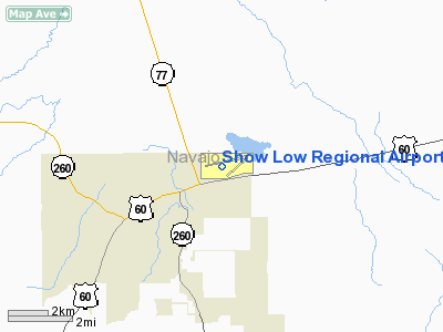
| Location |
Show Low, Arizona |
| Elevation AMSL |
6,415 ft / 1,955 m |
| Coordinates |
34°15′56″N 110°00′20″W / 34.26556°N 110.00556°W / 34.26556; -110.00556 |
| Runways |
| Direction |
Length |
Surface |
| ft |
m |
| 3/21 |
3,937 |
1,200 |
Asphalt |
| 6/24 |
7,200 |
2,195 |
Asphalt |
| Statistics (2006) |
| Aircraft operations |
34,014 |
| Source: Federal Aviation Administration |
Show Low Regional Airport (IATA: SOW, ICAO: KSOW, FAA LID: SOW) is a public airport located two miles (3 km) east of the central business district of Show Low, a city in Navajo County, Arizona, United States. It is mostly used for general aviation but is also served by one commercial airline. Service is subsidized by the Essential Air Service program.
As per Federal Aviation Administration records, the airport had 4,860 commercial passenger boardings (enplanements) in calendar year 2005 and 4,771 enplanements in 2006. According to the FAA's National Plan of Integrated Airport Systems for 2007–2011, Show Low Regional Airport is classified as commercial service - non-primary because it has between 2,500 and 10,000 passenger boardings per year. Airline and destination
| Airlines |
Destinations |
| Great Lakes Airlines |
Phoenix |
Facilities and aircraft
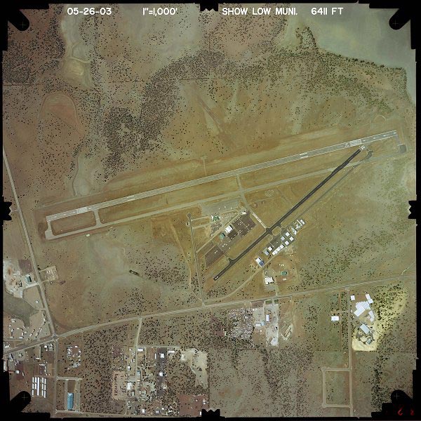
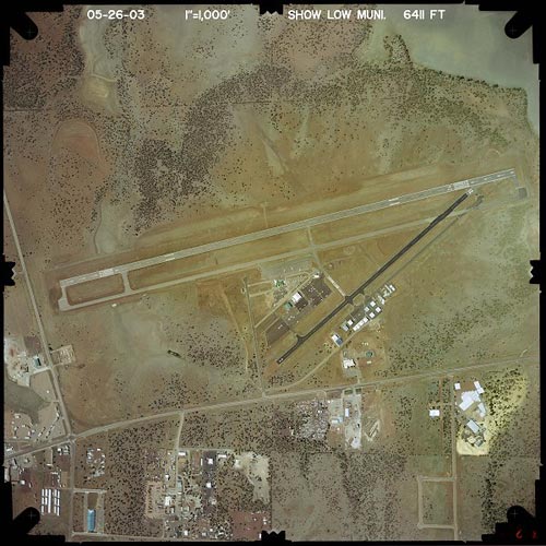
Show Low Regional Airport covers an area of 691 acres (280 ha) which contains two asphalt paved runways: 3/21 measuring 3,937 x 60 ft (1,200 x 18 m) and 6/24 measuring 7,200 x 100 ft (2,195 x 30 m).
For the 12-month period ending December 31, 2006, the airport had 34,014 aircraft operations, an average of 93 per day: 70% general aviation, 26% air taxi, 4% scheduled commercial and <1% military.
The above content comes from Wikipedia and is published under free licenses – click here to read more.
Location & QuickFacts
|
FAA
Information Effective: |
2005-10-27 |
|
Airport Identifier: |
SOW |
|
Longitude/Latitude: |
110-00-20.4000W/34-15-55.7000N
-110.005667/34.265472 (Estimated) |
|
Elevation: |
6415 ft / 1955.29 m (Surveyed) |
|
Land: |
340 acres |
|
From nearest city: |
2
nautical miles E of Show Low, AZ |
|
Location: |
Navajo County, AZ |
|
Magnetic Variation: |
12E (1985) |
Owner & Manager
|
Ownership: |
Publicly owned |
|
Owner: |
City Of Showlow |
|
Address: |
200 W. Cooley
Showlow, AZ 85901 |
|
Phone number: |
928-532-4000 |
|
Manager: |
Dennis Wiss |
|
Address: |
3150 Airport Loop, #100
Show Low, AZ 85901 |
|
Phone number: |
928-532-4192 |
Airport Operations and Facilities
|
Airport
Use: |
Open to public |
|
Wind indicator: |
Yes |
|
Segmented Circle: |
Yes |
|
Control Tower: |
No |
|
Attendance Schedule: |
ALL/ALL/0530-1930 |
|
Lighting Schedule: |
DUSK-DAWN
ACTVT MIRL RY 06/24 - 123.0. |
|
Beacon Color: |
Clear-Green (lighted land airport) |
|
Landing fee charge: |
No |
|
Sectional chart: |
Phoenix |
|
Region: |
AWP - Western-Pacific |
|
Traffic Pattern
Alt: |
800 ft |
|
Boundary ARTCC: |
ZAB - Albuquerque |
|
Tie-in FSS: |
PRC - Prescott |
|
FSS on Airport: |
No |
|
FSS Phone: |
928-778-7810 |
|
FSS Toll Free: |
1-800-WX-BRIEF |
|
NOTAMs Facility: |
SOW (NOTAM-d service avaliable) |
|
Federal Agreements: |
NGY |
Airport Communications
|
CTAF: |
123.000 |
|
Unicom: |
123.000 |
Airport Services
|
Fuel
available: |
100LLA
FUEL AVBL AFTER HOURS FOR CALL-OUT FEE. |
|
Bottled Oxygen: |
NONE |
|
Bulk Oxygen: |
NONE |
Runway Information
Runway 03/21
|
Dimension: |
3937 x 60 ft /
1200.0 x 18.3 m |
|
Surface: |
ASPH,
Good Condition |
|
|
Runway 03 |
Runway 21 |
|
Longitude: |
110-00-26.9149W |
109-59-52.1817W |
|
Latitude: |
34-15-38.0056N |
34-16-04.1644N |
|
Elevation: |
6413.00 ft |
6401.00 ft |
|
Alignment: |
48 |
127 |
|
Traffic Pattern: |
Right |
Left |
|
Markings: |
Basic, Good Condition |
Basic, Good Condition |
|
Runway End Identifier: |
No |
No |
|
Centerline Lights: |
No |
No |
|
Touchdown Lights: |
No |
No |
|
Runway 06/24
|
Dimension: |
7200 x 100 ft
/ 2194.6 x 30.5 m |
|
Surface: |
ASPH,
Good Condition |
|
Weight Limit: |
Single
wheel: 35000 lbs.
Dual wheel: 60000 lbs. |
|
Edge Lights: |
Medium
DELINEATORS. |
|
|
Runway 06 |
Runway 24 |
|
Longitude: |
110-01-07.9147W |
109-59-44.7076W |
|
Latitude: |
34-15-49.5915N |
34-16-06.8437N |
|
Elevation: |
6399.00 ft |
6400.00 ft |
|
Alignment: |
76 |
127 |
|
Traffic Pattern: |
Left |
Right |
|
Markings: |
Basic, Good Condition |
Non-precision instrument, Good Condition |
|
Crossing Height: |
30.00 ft |
40.00 ft |
|
Displaced threshold: |
700.00 ft |
750.00 ft |
|
VASI: |
2-light PAPI on left side |
2-light PAPI on left side |
|
Visual Glide Angle: |
3.00� |
3.00� |
|
Runway End Identifier: |
Yes |
Yes |
|
Centerline Lights: |
No |
No |
|
Touchdown Lights: |
No |
No |
|
Obstruction: |
38
ft pole, 823.0 ft from runway, 35 ft right of centerline,
16:1 slope to clear |
,
50:1 slope to clear
RY 06 APCH RATIO 40:1 TO DSPLCD THLD. |
|
Radio Navigation Aids
|
ID |
Type |
Name |
Ch |
Freq |
Var |
Dist |
|
SOW |
NDB |
Show
Low |
|
206.00 |
13E |
0.2
nm |
|
SJN |
VORTAC |
St
Johns |
070X |
112.30 |
12E |
43.8
nm |
Remarks
-
PART 77 OBSTRNS-WIND
SOCK IN 7-1 TRANSITION.
-
DEER/ELK/ANTELOPE INVOF
RY; CLEARING PASS RECOMMENDED AFTER DARK.
-
MILITARY TFC NEAR AIRPORT.
-
OVERNIGHT TRANSIENT
FEES AND COMMERCIAL OPERATOR LANDING FEES APPLICABLE.
Based Aircraft
|
Aircraft
based on field: |
56 |
|
Single Engine Airplanes: |
50 |
|
Multi Engine Airplanes: |
5 |
|
Jet Engine Airplanes: |
1 |
Operational Statistics
|
Aircraft
Operations: |
116/Day |
|
Air Carrier: |
2.0% |
|
Air Taxi: |
12.0% |
|
General Aviation
Local: |
16.7% |
|
General Aviation
Itinerant: |
66.6% |
|
Military: |
0.7% |
Show Low Regional
Airport
Address:
Navajo County,
AZ
Tel:
928-532-4000,
928-532-4192
|
 |
(Click on the image to enlarge) |
Images and information placed above are from
http://www.airport-data.com/airport/SOW/
http://www.dot.state.az.us/aviation/airports/airports_list.asp?FAA=SOW
We thank them for the data!
| General
Info |
| Country |
United
States |
| State |
ARIZONA
|
| FAA ID |
SOW |
| Latitude |
34-15-55.700N
|
| Longitude |
110-00-20.400W
|
| Elevation |
6415 feet
|
| Near City |
SHOW LOW
|
We don't guarantee the information is fresh and accurate. The data may be wrong or outdated.
For more up-to-date information please refer to other sources.
|
|